File:Departements of French Empire 1811-fr.svg
Jump to navigation
Jump to search

Size of this PNG preview of this SVG file: 800 × 600 pixels. Other resolutions: 320 × 240 pixels | 640 × 480 pixels | 1,024 × 768 pixels | 1,280 × 960 pixels | 2,560 × 1,920 pixels | 1,120 × 840 pixels.
Original file (SVG file, nominally 1,120 × 840 pixels, file size: 844 KB)
Captions
Captions
Add a one-line explanation of what this file represents
Summary[edit]
| Description |
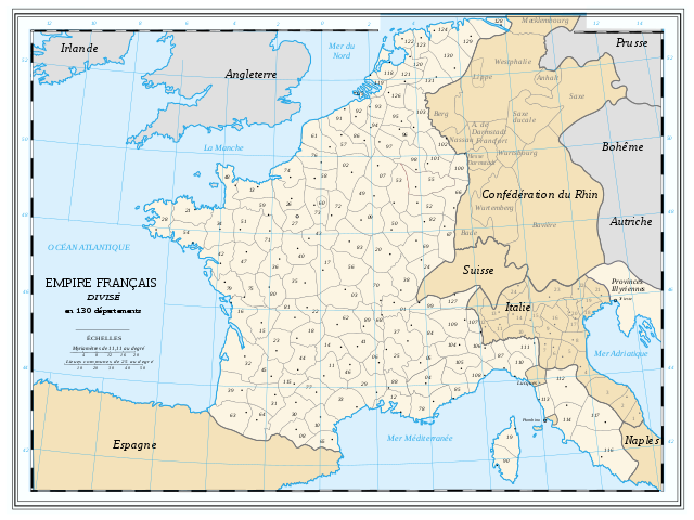
Français : Les départements du 1er Empire français (1811).
Attention: Cette carte est une carte historique. La qualité de sa précision ne permet pas une utilisation dans un contexte moderne. Les numéros de référence des départements français sont ceux en vigueur à l'époque. Ceux des provinces du royaume d'Italie sont arbitraires. Le département numéro 90 (Liamone) fut fusionné avec le numéro 19 (Golo) le 19 avril 1811 ; le département numéro 131 (Lippe) fut créé le 26 avril 1811 ; les départements numéros 90 (Liamone) et 131 n'ont donc jamais existé officiellement en même temps bien qu'ils soient tous deux représentés sur la carteEnglish: French Departments of the first Empire (1811)
Be careful: The map is an historical map. The precision is not sufficient for a modern use. The department numbers are the trues postal numbers. Provinces numbers of the italian kingdom are arbitraries. The department number 90 (Liamone) was merged with number 19 (Golo) on April 19th 1811 ; the department number 131 (Lippe) was created on April 26th 1811 ; therefore both departments 90 (Liamone) and 131 never existed officially at the same time although they are both drawn on the map |
| Date | |
| Source | Tiré d'une carte établie en 1811 par Messieurs Drioux et Leroy (voir la carte de l’Empire français divisé en 130 départements, par MM. Drioux et Leroy, également sur Commons : Dep-fr.jpg). |
| Author | Ewan ar Born |
This W3C-unspecified vector image was created with Inkscape .

|
This SVG file contains embedded text that can be translated into your language, using any capable SVG editor, text editor or the SVG Translate tool. For more information see: About translating SVG files. |
Licensing[edit]
| I, the copyright holder of this work, release this work into the public domain. This applies worldwide. In some countries this may not be legally possible; if so: I grant anyone the right to use this work for any purpose, without any conditions, unless such conditions are required by law. |
File history
Click on a date/time to view the file as it appeared at that time.
| Date/Time | Thumbnail | Dimensions | User | Comment | |
|---|---|---|---|---|---|
| current | 23:55, 12 September 2009 | | 1,120 × 840 (844 KB) | Carfois (talk | contribs) | Ajouts des quelques numéros de département manquants / Addition of all missing department numbers |
| 12:44, 8 July 2008 |  | 1,120 × 840 (849 KB) | Ewan ar Born (talk | contribs) | {{Information |Description={{fr|1=Les départements du 1{{er}} Empire français (1811). Attention: Cette carte est une carte historique. La qualité de sa précision ne permet pas une utilisation dans un contexte moderne. Les nombres de référence des d |
You cannot overwrite this file.
File usage on Commons
There are no pages that use this file.
File usage on other wikis
The following other wikis use this file:
- Usage on eo.wikipedia.org
- Usage on fr.wikipedia.org
- Usage on it.wikipedia.org
- Usage on ro.wikipedia.org