File:Deutschland Autobahnen.svg

File originale (file in formato SVG, dimensioni nominali 1 073 × 1 272 pixel, dimensione del file: 467 KB)
Didascalie
Didascalie
Dettagli[modifica]
| Descrizione |
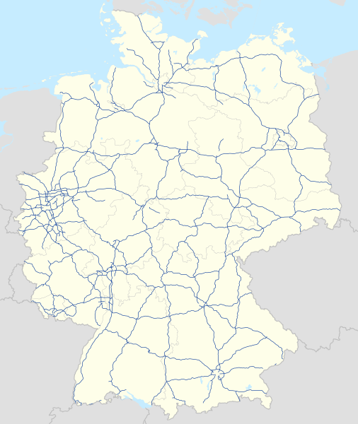
Deutsch: Karte der Autobahnen in Deutschland, Alternativkarte zu file:Germany location map.svg
|
||
| Data | |||
| Fonte | Opera propria | ||
| Autore | NordNordWest | ||
| Licenza (Riusare questo file) |
Questo file è disponibile in base alla licenza Creative Commons Attribuzione-Condividi allo stesso modo 3.0 Germania.
 Questo file è disponibile in base alla licenza Creative Commons Attribuzione-Condividi allo stesso modo 3.0 Unported
|
||
| Altre versioni |
Bundesrepublik Deutschland (vor 1990 nur West-Deutschland):
Deutsche Demokratische Republik (mit BRD im Ausschnitt):
Ostdeutschland (vor 1990 Deutsche Demokratische Republik):
Deutschland zwischen Mai 1945 und Oktober 1949:
Thematisch:
Deutsches Reich (1918–1945) (best used with this template (de)):
|
||
| SVG sviluppo | Questa mappa in grafica vettoriale è stata creata con un programma SVG ignoto.
|


_23_May_1949_-_6_Oct_1949.svg)


_location_map.svg)
_location_map_2013.svg)


Cronologia del file
Fare clic su un gruppo data/ora per vedere il file come si presentava nel momento indicato.
| Data/Ora | Miniatura | Dimensioni | Utente | Commento | |
|---|---|---|---|---|---|
| attuale | 13:19, 14 dic 2023 | | 1 073 × 1 272 (467 KB) | NordNordWest (discussione | contributi) | upd |
| 16:23, 18 lug 2023 |  | 1 073 × 1 272 (467 KB) | NordNordWest (discussione | contributi) | upd | |
| 17:59, 1 feb 2023 |  | 1 073 × 1 272 (466 KB) | NordNordWest (discussione | contributi) | upd | |
| 14:40, 18 nov 2019 |  | 1 073 × 1 272 (465 KB) | NordNordWest (discussione | contributi) | upd | |
| 17:36, 27 set 2019 |  | 1 073 × 1 272 (465 KB) | NordNordWest (discussione | contributi) | upd | |
| 18:08, 5 ago 2019 |  | 1 073 × 1 272 (465 KB) | NordNordWest (discussione | contributi) | upd | |
| 07:02, 14 gen 2019 |  | 1 073 × 1 272 (467 KB) | NJ Giggie (discussione | contributi) | upd: A33 Teilstück freigegeben | |
| 18:26, 23 dic 2018 |  | 1 073 × 1 272 (466 KB) | NordNordWest (discussione | contributi) | upd | |
| 11:22, 4 set 2018 |  | 1 073 × 1 272 (466 KB) | NJ Giggie (discussione | contributi) | corr: Autobahnenden der A61 gehen über die Kreuze Wanlo und Jackerath jeweils hinaus. Wiederherstellung des korrigierten Verlaufs der A448. | |
| 09:50, 2 set 2018 |  | 1 073 × 1 272 (465 KB) | NordNordWest (discussione | contributi) | upd |
Impossibile sovrascrivere questo file.
Utilizzo del file
Le seguenti 73 pagine usano questo file:
- User:Chumwa/OgreBot/Potential transport maps/2018 April 1-10
- User:Chumwa/OgreBot/Potential transport maps/2018 April 11-20
- User:Chumwa/OgreBot/Potential transport maps/2018 August 21-31
- User:Chumwa/OgreBot/Potential transport maps/2018 December 21-31
- User:Chumwa/OgreBot/Potential transport maps/2018 January 11-20
- User:Chumwa/OgreBot/Potential transport maps/2018 January 21-31
- User:Chumwa/OgreBot/Potential transport maps/2018 June 21-30
- User:Chumwa/OgreBot/Potential transport maps/2018 March 1-10
- User:Chumwa/OgreBot/Potential transport maps/2018 September 1-10
- User:Chumwa/OgreBot/Potential transport maps/2019 August 1-10
- User:Chumwa/OgreBot/Potential transport maps/2019 January 11-20
- User:Chumwa/OgreBot/Potential transport maps/2019 November 11-20
- User:Chumwa/OgreBot/Potential transport maps/2019 September 21-30
- User:Chumwa/OgreBot/Transport Maps/2018 April 1-10
- User:Chumwa/OgreBot/Transport Maps/2018 April 11-20
- User:Chumwa/OgreBot/Transport Maps/2018 August 21-31
- User:Chumwa/OgreBot/Transport Maps/2018 December 21-31
- User:Chumwa/OgreBot/Transport Maps/2018 January 11-20
- User:Chumwa/OgreBot/Transport Maps/2018 January 21-31
- User:Chumwa/OgreBot/Transport Maps/2018 June 21-30
- User:Chumwa/OgreBot/Transport Maps/2018 March 1-10
- User:Chumwa/OgreBot/Transport Maps/2018 September 1-10
- User:Chumwa/OgreBot/Transport Maps/2019 August 1-10
- User:Chumwa/OgreBot/Transport Maps/2019 January 11-20
- User:Chumwa/OgreBot/Transport Maps/2019 November 11-20
- User:Chumwa/OgreBot/Transport Maps/2019 September 21-30
- User:Chumwa/OgreBot/Transport Maps/2023 December 11-20
- User:Chumwa/OgreBot/Transport Maps/2023 February 1-9
- User:Chumwa/OgreBot/Transport Maps/2023 July 11-20
- User:Chumwa/OgreBot/Travel and communication maps/2018 April 1-10
- User:Chumwa/OgreBot/Travel and communication maps/2018 April 11-20
- User:Chumwa/OgreBot/Travel and communication maps/2018 August 21-31
- User:Chumwa/OgreBot/Travel and communication maps/2018 December 21-31
- User:Chumwa/OgreBot/Travel and communication maps/2018 January 11-20
- User:Chumwa/OgreBot/Travel and communication maps/2018 January 21-31
- User:Chumwa/OgreBot/Travel and communication maps/2018 June 21-30
- User:Chumwa/OgreBot/Travel and communication maps/2018 March 1-10
- User:Chumwa/OgreBot/Travel and communication maps/2018 September 1-10
- User:Chumwa/OgreBot/Travel and communication maps/2019 August 1-10
- User:Chumwa/OgreBot/Travel and communication maps/2019 January 11-20
- User:Chumwa/OgreBot/Travel and communication maps/2019 November 11-20
- User:Chumwa/OgreBot/Travel and communication maps/2019 September 21-30
- User:Chumwa/OgreBot/Travel and communication maps/2023 December 11-20
- User:Chumwa/OgreBot/Travel and communication maps/2023 February 1-9
- User:Chumwa/OgreBot/Travel and communication maps/2023 July 11-20
- File:Deutschland Autobahnen.svg
- File:East-West-Germany-October 1949-July 1952.svg
- File:East Germany location map.svg
- File:Germany, Federal Republic of location map 23 May 1949 - 6 Oct 1949.svg
- File:Germany, Federal Republic of location map April 1952 - August 1955.svg
- File:Germany, Federal Republic of location map December 1950 - April 1952.svg
- File:Germany, Federal Republic of location map January 1957 - October 1990.svg
- File:Germany, Federal Republic of location map October 1949 - November 1950.svg
- File:Germany, Federal Republic of location map September 1955 - December 1956.svg
- File:Germany, German Democratic Republic location map January 1957 - October 1990.svg
- File:Germany, German Democratic Republic location map July 1952 - January 1957.svg
- File:Germany, German Democratic Republic location map October 1949 - July 1952.svg
- File:Germany, German Democratic Republic location map w·o FRG July 1952 - October 1990.svg
- File:Germany, German Democratic Republic location map w·o FRG October 1949 - June 1952.svg
- File:Germany, location map (SBZ perspective) 23 May 1949 - 6 Oct 1949.svg
- File:Germany2 location map.svg
- File:Germany location map.svg
- File:Germany location map 23 April 1949 - 22 May 1949.svg
- File:Germany location map 8 Jun 1947 - 22 Apr 1949.svg
- File:Germany location map April 1992 - July 1992.svg
- File:Germany location map August 1992 - June 1993.svg
- File:Germany location map July 1993 - December 2009.svg
- File:Germany location map October 1990 - March 1992.svg
- File:Germany location map labeled 8 Jun 1947 - 22 Apr 1949.svg
- File:Lage Freiberg in Deutschland.png
- File:Relief Map of Germany.png
- File:Relief Map of Germany.svg
- Template:Germany location map/other versions
Utilizzo globale del file
Anche i seguenti wiki usano questo file:
- Usato nelle seguenti pagine di de.wikipedia.org:
- Usato nelle seguenti pagine di es.wikipedia.org:
- Usato nelle seguenti pagine di fi.wikipedia.org:
- Usato nelle seguenti pagine di gl.wikipedia.org:
- Usato nelle seguenti pagine di it.wikipedia.org:
- Usato nelle seguenti pagine di nl.wikipedia.org:
- Usato nelle seguenti pagine di ro.wikipedia.org:
- Usato nelle seguenti pagine di www.wikidata.org: