File:Dithmarschen.Deiche.png
Original file (910 × 1,000 pixels, file size: 495 KB, MIME type: image/png)
Captions
Captions
|
Summary
[edit]
| Description |
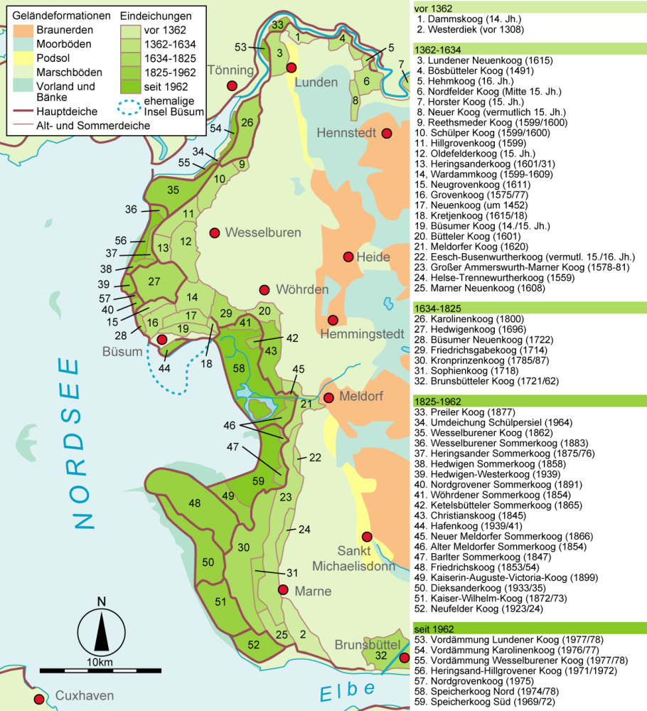
Geschichte des Deichbaus in Dithmarschen. Die Perioden sind wie folgt eingeteilt: Vor 1362 1362-1634 1634-1825 1825-1962 seit 1962 |
| Date | |
| Source | Hauptquellen: Topographische Karte; Geschichte Dithmarschens, Westholsteinischer Verlag Boyens, Heide 2000; Agrar- und Umweltatlas Schleswig-Holstein, Geschichte Schleswig-Holsteins: Sturmflut und Geschichte Schleswig-Hilsteins: Deichbau |
| Author | Begw mit tatkräftiger Unterstützung durch de:Benutzer:Jom und de:Benutzer:Southpark |
| Other versions |
 |
Licensing
[edit]

|
Permission is granted to copy, distribute and/or modify this document under the terms of the GNU Free Documentation License, Version 1.2 or any later version published by the Free Software Foundation; with no Invariant Sections, no Front-Cover Texts, and no Back-Cover Texts. A copy of the license is included in the section entitled GNU Free Documentation License. |
| This file is licensed under the Creative Commons Attribution-Share Alike 3.0 Unported license. | ||
| ||
| This licensing tag was added to this file as part of the GFDL licensing update. |
- You are free:
- to share – to copy, distribute and transmit the work
- to remix – to adapt the work
- Under the following conditions:
- attribution – You must give appropriate credit, provide a link to the license, and indicate if changes were made. You may do so in any reasonable manner, but not in any way that suggests the licensor endorses you or your use.
- share alike – If you remix, transform, or build upon the material, you must distribute your contributions under the same or compatible license as the original.
File history
Click on a date/time to view the file as it appeared at that time.
| Date/Time | Thumbnail | Dimensions | User | Comment | |
|---|---|---|---|---|---|
| current | 20:35, 10 June 2015 | | 910 × 1,000 (495 KB) | NordNordWest (talk | contribs) | Legende korrigiert, 1925 -> 1825 |
| 10:51, 10 February 2014 |  | 910 × 1,000 (411 KB) | Kopiersperre (talk | contribs) | optipng | |
| 02:40, 11 August 2007 |  | 910 × 1,000 (547 KB) | Begw (talk | contribs) | {{Information |Description=Geschichte des Deichbaus in Dithmarschen |Source=Hauptquellen: Topographische Karte; Geschichte Dithmarschens, Westholsteinischer Verlag Boyens, Heide 2000; [http://www.umweltdaten.landsh.de/atlas/script/index.php Agrar- und Umw |
You cannot overwrite this file.
File usage on Commons
The following 2 pages use this file:
File usage on other wikis
The following other wikis use this file:
- Usage on da.wikipedia.org
- Usage on de.wikipedia.org
- Dithmarschen
- Portal Diskussion:Geographie/Bild des Monats
- Benutzer:Jom/baustelle
- Wikipedia:Exzellente Bilder/Karten und Satellitenbilder
- Benutzer:Jom/Liste der Köge in Dithmarschen
- Wikipedia:Kandidaten für exzellente Bilder/Archiv2007/13
- Datei:Dithmarschen.Deiche.png
- Benutzer:Begw/Spickzettel
- Wikipedia:Exzellente Bilder/Kleine Bilder
- Usage on uk.wikipedia.org