File:French Peloponnesian expedition map-fr.svg
Jump to navigation
Jump to search

Size of this PNG preview of this SVG file: 800 × 539 pixels. Other resolutions: 320 × 216 pixels | 640 × 431 pixels | 1,024 × 690 pixels | 1,280 × 862 pixels | 2,560 × 1,725 pixels | 1,900 × 1,280 pixels.
Original file (SVG file, nominally 1,900 × 1,280 pixels, file size: 1.22 MB)
Captions
Captions
Add a one-line explanation of what this file represents
Summary[edit]
| Description |
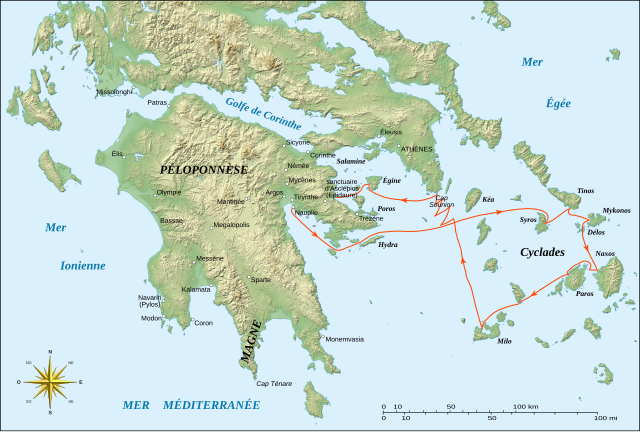
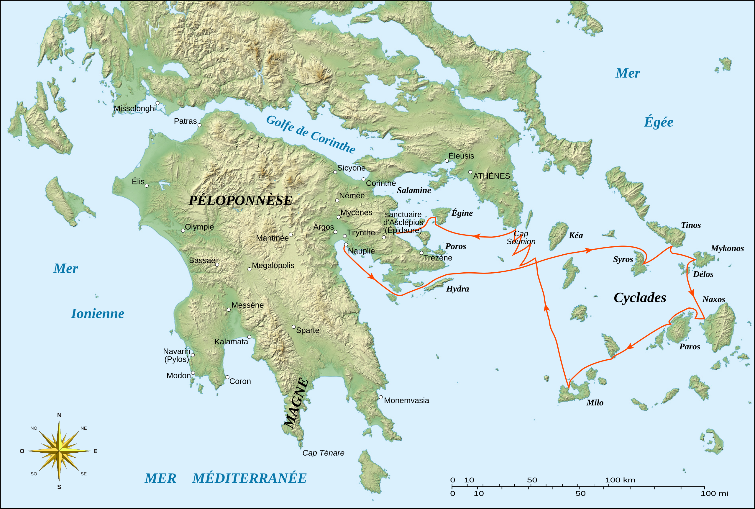
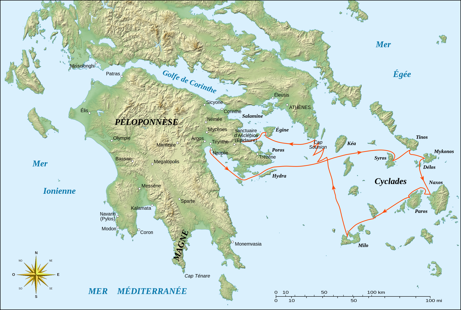
English: Map of Greece to illustrate the French expedition in Peloponnese between 1828 and 1833 during the Greek War of Independence, with part of the scientific travel to the Cyclades islands.
Note: This map shows part of the geography of Greece as it was during the 19th century, specifically for the lakes, like Lake Copais which doesn't exist anymore. Français : Carte de la Grèce destinée à illustrer l'expédition française de Morée entre 1828 et 1833 durant la guerre d'indépendance grecque, avec une partie du voyage scientifique dans les Cyclades. UTM projection, WGS84 datum |
||
| Date | |||
| Source |
Own work (former raster version : Image:French_Peloponnesian_expedition_map-fr.jpg);
|
||
| Author | Eric Gaba (Sting - fr:Sting) | ||
| Permission (Reusing this file) |
|
||
| Other versions |
|


|
This SVG file contains embedded text that can be translated into your language, using any capable SVG editor, text editor or the SVG Translate tool. For more information see: About translating SVG files. |
Licensing[edit]
I, the copyright holder of this work, hereby publish it under the following licenses:

|
Permission is granted to copy, distribute and/or modify this document under the terms of the GNU Free Documentation License, Version 1.2 or any later version published by the Free Software Foundation; with no Invariant Sections, no Front-Cover Texts, and no Back-Cover Texts. A copy of the license is included in the section entitled GNU Free Documentation License. |
This file is licensed under the Creative Commons Attribution-Share Alike 3.0 Unported, 2.5 Generic, 2.0 Generic and 1.0 Generic license.
- You are free:
- to share – to copy, distribute and transmit the work
- to remix – to adapt the work
- Under the following conditions:
- attribution – You must give appropriate credit, provide a link to the license, and indicate if changes were made. You may do so in any reasonable manner, but not in any way that suggests the licensor endorses you or your use.
- share alike – If you remix, transform, or build upon the material, you must distribute your contributions under the same or compatible license as the original.
You may select the license of your choice.
File history
Click on a date/time to view the file as it appeared at that time.
| Date/Time | Thumbnail | Dimensions | User | Comment | |
|---|---|---|---|---|---|
| current | 20:43, 31 January 2020 | | 1,900 × 1,280 (1.22 MB) | Εὐθυμένης (talk | contribs) | File uploaded using svgtranslate tool (https://tools.wmflabs.org/svgtranslate/). Added translation for el. |
| 04:26, 20 October 2007 |  | 1,900 × 1,280 (1.17 MB) | Sting (talk | contribs) | {{Information| |Description=Map of Greece to illustrate the French expedition in Peloponnese between 1828 and 1833 during the Greek War of Independence, with part of the scientific travel to |
You cannot overwrite this file.
File usage on Commons
The following 3 pages use this file:
File usage on other wikis
The following other wikis use this file:
- Usage on fr.wikipedia.org
- Usage on it.wikipedia.org
- Usage on ro.wikipedia.org