File:Hamburger Hochbahn - Plan der Linie U1.png
Vai alla navigazione
Vai alla ricerca

Dimensioni di questa anteprima: 676 × 600 pixel. Altre risoluzioni: 271 × 240 pixel | 541 × 480 pixel | 866 × 768 pixel | 1 154 × 1 024 pixel | 2 309 × 2 048 pixel | 2 895 × 2 568 pixel.
File originale (2 895 × 2 568 pixel, dimensione del file: 528 KB, tipo MIME: image/png)
Didascalie
Didascalie
Aggiungi una brevissima spiegazione di ciò che questo file rappresenta
| Descrizione |
|
| Data | see file history |
| Fonte |
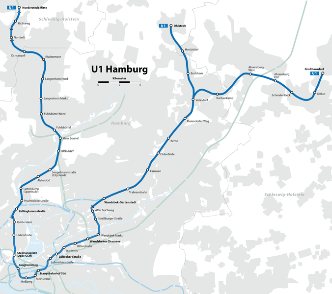
Self made, using the information from
and using the following graphic: Created with Adobe Illustrator 13.0 If you ask for, I will give you the .ai-file or I'll correct it or create other language versions. |
| Autore | Maximilian Dörrbecker (Chumwa) |
| Licenza (Riusare questo file) |
Io, detentore del copyright su quest'opera, dichiaro di pubblicarla con la seguente licenza: Questo file è disponibile in base alla licenza Creative Commons Attribuzione-Condividi allo stesso modo 2.5 Generico
Sie dürfen das Bild zu den folgenden Bedingungen nutzen:
|
| Altre versioni |
|

.png)


Cronologia del file
Fare clic su un gruppo data/ora per vedere il file come si presentava nel momento indicato.
| Data/Ora | Miniatura | Dimensioni | Utente | Commento | |
|---|---|---|---|---|---|
| attuale | 10:20, 12 mar 2022 | | 2 895 × 2 568 (528 KB) | NordNordWest (discussione | contributi) | update (U4 extension) |
| 13:03, 11 gen 2020 |  | 2 895 × 2 568 (528 KB) | NordNordWest (discussione | contributi) | update (Oldenfelde) | |
| 20:29, 21 giu 2017 |  | 2 895 × 2 568 (774 KB) | Chumwa (discussione | contributi) | update (U4 extension) | |
| 18:02, 31 mag 2009 |  | 2 895 × 2 568 (754 KB) | Chumwa (discussione | contributi) | {{Information |Description= *{{ de }} Karte der Linie U1 der Hamburger Hochbahn *{{ en }} Map of Hochbahn Hamburg route U1 |Source=Self made, using the information from * de:Hamburger Hochbahn * de:U-Bahn Hamburg (from [http://de.wikipedia.org/w |
Impossibile sovrascrivere questo file.
Utilizzo del file
Le seguenti 22 pagine usano questo file:
- User:Chumwa/Gallery
- User:Chumwa/OgreBot/Potential transport maps/2017 June 21-30
- User:Chumwa/OgreBot/Potential transport maps/2020 January 11-20
- User:Chumwa/OgreBot/Public transport information/2017 June 21-30
- User:Chumwa/OgreBot/Public transport information/2020 January 11-20
- User:Chumwa/OgreBot/Public transport information/2022 March 11-20
- User:Chumwa/OgreBot/Transport Maps/2017 June 21-30
- User:Chumwa/OgreBot/Transport Maps/2020 January 11-20
- User:Chumwa/OgreBot/Transport Maps/2022 March 11-20
- User:Chumwa/OgreBot/Travel and communication maps/2017 June 21-30
- User:Clic/Nahverkehr in Deutschland/2020 January 11-20
- User:Clic/Nahverkehr in Deutschland/2022 March 11-20
- File:Hamburger Hochbahn - Entwicklungsgeschichte.png
- File:Hamburger Hochbahn - Linienplan.png
- File:Hamburger Hochbahn - Linienplan (mit Tunnels).png
- File:Hamburger Hochbahn - Plan der Linie U1.png
- File:Hamburger Hochbahn - Plan der Linie U2.png
- File:Hamburger Hochbahn - Plan der Linie U2 bis 2009.png
- File:Hamburger Hochbahn - Plan der Linie U3.png
- File:Hamburger Hochbahn - Plan der Linie U3 bis 2009.png
- File:Hamburger Hochbahn - Plan der Linie U4.png
- Category:U-Bahnlinie U1 (Hamburg)
Utilizzo globale del file
Anche i seguenti wiki usano questo file:
- Usato nelle seguenti pagine di ca.wikipedia.org:
- Usato nelle seguenti pagine di de.wikipedia.org:
- Usato nelle seguenti pagine di de.wiktionary.org:
- Usato nelle seguenti pagine di en.wikipedia.org:
- Usato nelle seguenti pagine di fr.wikipedia.org:
- Ahrensburg West (métro de Hambourg)
- Kellinghusenstraße (métro de Hambourg)
- Gare de Norderstedt Mitte
- Wandsbek Markt (métro de Hambourg)
- Lübecker Straße (métro de Hambourg)
- Gare de Hambourg-Jungfernstieg
- Gare de Hambourg-Wandsbeker Chaussee
- Meßberg (métro de Hambourg)
- Alter Teichweg (métro de Hambourg)
- Klosterstern (métro de Hambourg)
- Lattenkamp (métro de Hambourg)
- Sengelmannstraße (métro de Hambourg)
- Hudtwalckerstraße (métro de Hambourg)
- Usato nelle seguenti pagine di it.wikipedia.org:
- Usato nelle seguenti pagine di nl.wikipedia.org:
- Usato nelle seguenti pagine di pl.wikipedia.org:
- Usato nelle seguenti pagine di sv.wikipedia.org:
- Usato nelle seguenti pagine di www.wikidata.org: