File:Hills and vineyards, Roquebrun.jpg
Jump to navigation
Jump to search

Size of this preview: 800 × 500 pixels. Other resolutions: 320 × 200 pixels | 640 × 400 pixels | 1,024 × 640 pixels | 1,280 × 800 pixels | 2,560 × 1,600 pixels | 7,360 × 4,600 pixels.
Original file (7,360 × 4,600 pixels, file size: 30.97 MB, MIME type: image/jpeg)
Captions
Captions
Add a one-line explanation of what this file represents
Summary[edit]
| Description |
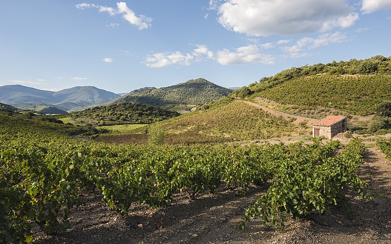
Français : Des collines et des vignes dans la vallée de l'Orb. Roquebrun, Hérault, France. Parc naturel régional du Haut-Languedoc. English: Hills and vineyards in the Orb River Valley.
Roquebrun, Hérault, France. Haut-Languedoc Regional Natural Park. Español: Colinas y viñedos en el valle del río Orb.
Roquebrun, Hérault, France. Parque natural regional de Haut-Languedoc. Bosanski: Brda i vinogradi u dolini rijeke Orb, Francuska.
Čeština: Kopce a vinohrady v údolí řeky Orb, Francie.
Esperanto: Montetoj kaj vinberujoj en la valo de la rivero Orb, Francio.
한국어: 프랑스 오브 강 하곡의 언덕과 포도밭.
Polski: Wzgórza i winnice w dolinie rzeki Orb we Francji.
Slovenčina: Kopce a vinohrady v údolí rieky Orb, Francúzsko. |
| Date | Taken on 2 October 2014, 16:50:47 |
| Source | Own work |
| Author | Christian Ferrer |
| Permission (Reusing this file) |
I, the copyright holder of this work, hereby publish it under the following license: This file is licensed under the Creative Commons Attribution-Share Alike 4.0 International license.
|
| Camera location | | View this and other nearby images on: OpenStreetMap |
|---|
|
This image was selected as picture of the day on Wikimedia Commons for 21 December 2014. It was captioned as follows: English: Hills and vineyards in the Orb River Valley, France. Other languages:
Bosanski: Brda i vinogradi u dolini rijeke Orb, Francuska. Čeština: Kopce a vinohrady v údolí řeky Orb, Francie. English: Hills and vineyards in the Orb River Valley, France. Esperanto: Montetoj kaj vinberujoj en la valo de la rivero Orb, Francio. Français : Des collines et des vignes dans la vallée de l'Orb, France. Polski: Wzgórza i winnice w dolinie rzeki Orb we Francji. Slovenčina: Kopce a vinohrady v údolí rieky Orb, Francúzsko. 한국어: 프랑스 오브 강 하곡의 언덕과 포도밭. |
File history
Click on a date/time to view the file as it appeared at that time.
| Date/Time | Thumbnail | Dimensions | User | Comment | |
|---|---|---|---|---|---|
| current | 20:54, 9 November 2014 | | 7,360 × 4,600 (30.97 MB) | Christian Ferrer (talk | contribs) | sharp |
| 20:35, 9 November 2014 |  | 7,360 × 4,600 (27.57 MB) | Christian Ferrer (talk | contribs) | cAs | |
| 16:19, 7 November 2014 |  | 7,360 × 4,600 (29.27 MB) | Christian Ferrer (talk | contribs) | ajustements | |
| 16:09, 3 November 2014 |  | 7,360 × 4,600 (29.77 MB) | Christian Ferrer (talk | contribs) | color, highlights | |
| 22:36, 1 November 2014 |  | 7,360 × 4,600 (28.45 MB) | Christian Ferrer (talk | contribs) | User created page with UploadWizard |
You cannot overwrite this file.
File usage on Commons
The following 33 pages use this file:
- Roquebrun
- User:Miya/POTY/2014
- User:Zyephyrus/2015
- User:Zziccardi/Favorites
- User talk:Christian Ferrer/Archive10
- Commons:Featured picture candidates/File:Hills and vineyards, Roquebrun.jpg
- Commons:Featured picture candidates/Log/November 2014
- Commons:Featured pictures/Places/Natural/France
- Commons:Featured pictures/chronological/2014-B
- Commons:Picture of the Year/2014/Candidates
- Commons:Picture of the Year/2014/R1/Gallery/2014-B
- Commons:Picture of the Year/2014/R1/Gallery/ALL
- Commons:Picture of the Year/2014/R1/Gallery/M11
- Commons:Picture of the Year/2014/R1/Gallery/Nature views
- Commons:Picture of the Year/2014/R1/Results/Candidates
- Commons:Picture of the Year/2014/R1/Results/Candidates/Nature views
- Commons:Picture of the Year/2014/R1/Results/Nature views
- Commons:Picture of the Year/2014/R1/v/Hills and vineyards, Roquebrun.jpg
- Commons:Quality images/Subject/Places/Natural structures/archive 2013 to 2014
- Commons:Quality images candidates/Archives November 05 2014
- Template:Potd/2014-12
- Template:Potd/2014-12-21
- Template:Potd/2014-12-21 (bs)
- Template:Potd/2014-12-21 (cs)
- Template:Potd/2014-12-21 (en)
- Template:Potd/2014-12-21 (eo)
- Template:Potd/2014-12-21 (fr)
- Template:Potd/2014-12-21 (hu)
- Template:Potd/2014-12-21 (it)
- Template:Potd/2014-12-21 (ko)
- Template:Potd/2014-12-21 (nl)
- Template:Potd/2014-12-21 (pl)
- Template:Potd/2014-12-21 (sk)
File usage on other wikis
The following other wikis use this file:
- Usage on be-tarask.wikipedia.org
- Usage on bn.wikipedia.org
- Usage on crh.wikipedia.org
- Usage on cv.wikipedia.org
- Usage on de.wikivoyage.org
- Usage on en.wikipedia.org
- Usage on eo.wikipedia.org
- Usage on fr.wikipedia.org
- Usage on ga.wikipedia.org
- Usage on hu.wikipedia.org
- Usage on it.wikipedia.org
- Usage on kab.wikipedia.org
- Usage on ka.wikipedia.org
- Usage on ko.wikipedia.org
- Usage on krc.wikipedia.org
- Usage on la.wikipedia.org
- Usage on lbe.wikipedia.org
- Usage on oc.wikipedia.org
- 1r d'octobre
- Octòbre
- 2 d'octobre
- 3 d'octobre
- 4 d'octobre
- 5 d'octobre
- 6 d'octobre
- 7 d'octobre
- 8 d'octobre
- 9 d'octobre
- 10 d'octobre
- 11 d'octobre
- 12 d'octobre
- 13 d'octobre
- 14 d'octobre
- 15 d'octobre
- 16 d'octobre
- 18 d'octobre
- 19 d'octobre
- 20 d'octobre
- 21 d'octobre
- 22 d'octobre
- 23 d'octobre
- 24 d'octobre
- 25 d'octobre
- 26 d'octobre
View more global usage of this file.