File:Ionian Islands.svg
Bước tới điều hướng
Bước tới tìm kiếm

Kích thước bản xem trước PNG này của tập tin SVG: 532×547 điểm ảnh. Độ phân giải khác: 233×240 điểm ảnh | 467×480 điểm ảnh | 747×768 điểm ảnh | 996×1.024 điểm ảnh | 1.992×2.048 điểm ảnh.
Tập tin gốc (tập tin SVG, 532×547 điểm ảnh trên danh nghĩa, kích thước: 281 kB)
Chú thích
Chú thích
Ghi một dòng giải thích những gì có trong tập tin này

|
This map has been uploaded by Electionworld from en.wikipedia.org to enable the |
Miêu tả
[sửa]
| Miêu tả |
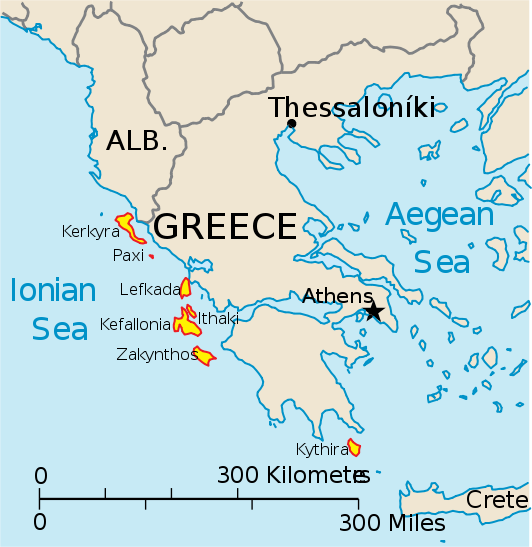
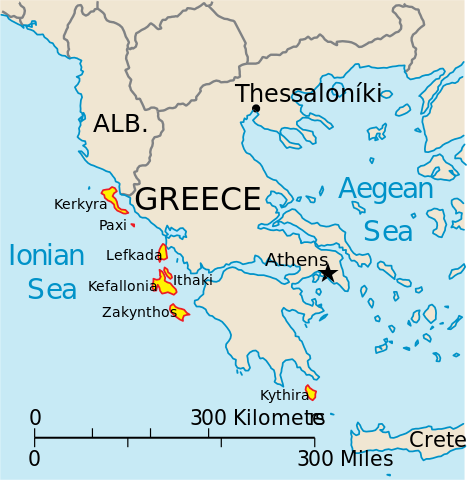
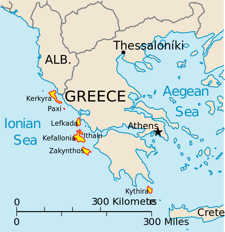
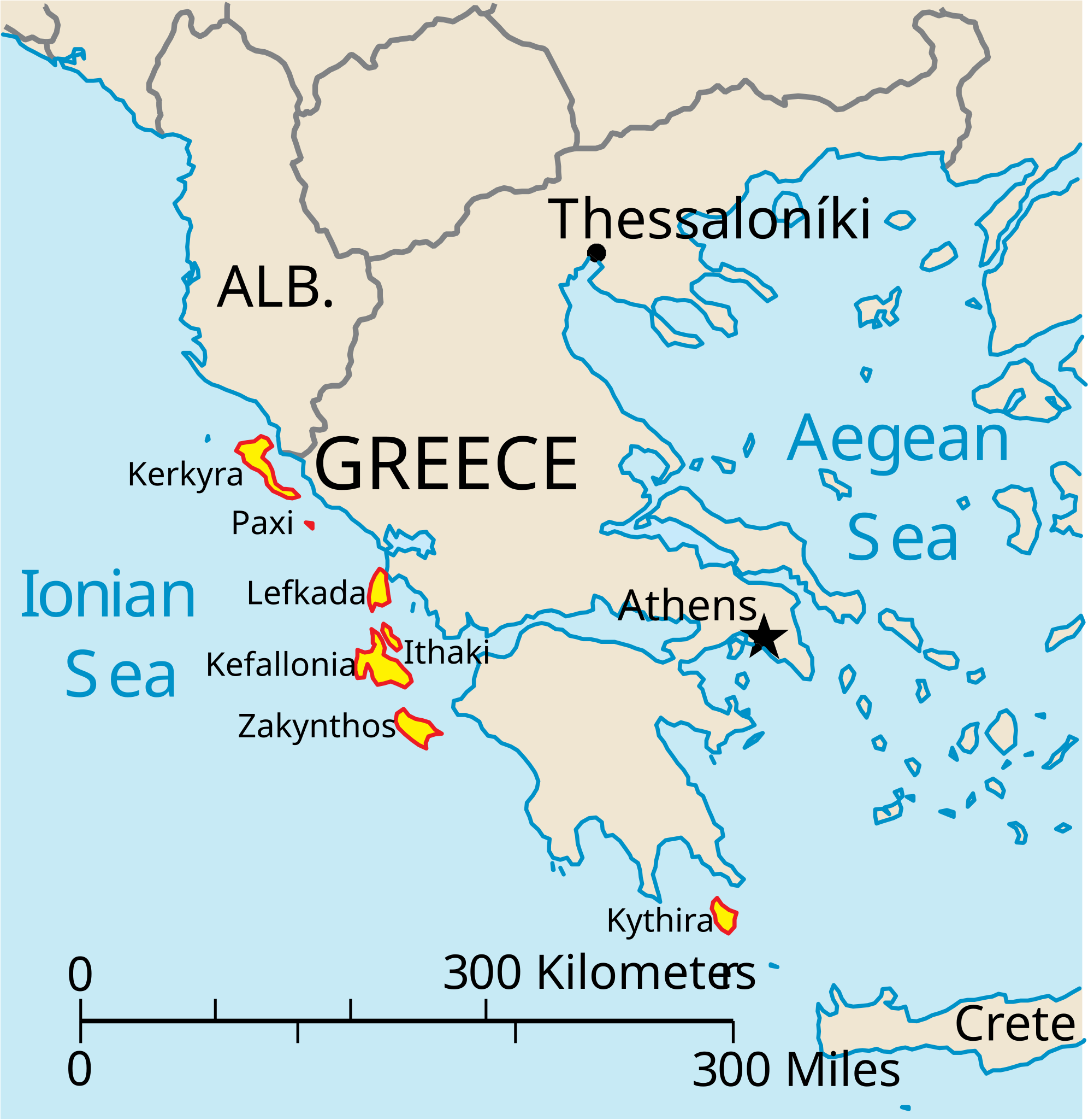
English: Map of the Ionian Islands off Greece. |
| Ngày | |
| Nguồn gốc | Tác phẩm được tạo bởi người tải lên, Original vector data taken from the 2006 CIA World Factbook map of Europe. All modifications were made by me, and are free for anyone to use for any purpose. |
| Tác giả | Electionworld |
| Phiên bản khác |
Version en français : |
Giấy phép
[sửa]
This image is in the public domain because it contains materials that originally came from the United States Central Intelligence Agency's World Factbook.
|
 |
Lịch sử tập tin
Nhấn vào ngày/giờ để xem nội dung tập tin tại thời điểm đó.
| Ngày/Giờ | Hình xem trước | Kích cỡ | Thành viên | Miêu tả | |
|---|---|---|---|---|---|
| hiện tại | 14:39, ngày 4 tháng 4 năm 2010 | | 532×547 (281 kB) | Kmusser (thảo luận | đóng góp) | rm Macedonia label, not important to the map and avoids POV issue |
| 20:17, ngày 20 tháng 12 năm 2006 |  | 532×547 (258 kB) | Electionworld (thảo luận | đóng góp) | {{ew|en|IMeowbot}} == Summary == Map of the Ionian Islands off Greece. Original vector data taken from the 2006 CIA World Factbook map of Europe. All modifications were made by me, and are free for anyone to use for any purpose. == Licensing == {{PD-US |
Bạn không được phép ghi đè tập tin này.
Trang sử dụng tập tin
4 trang sau sử dụng tập tin này:
Sử dụng tập tin toàn cục
Những wiki sau đang sử dụng tập tin này:
- Trang sử dụng tại ar.wikipedia.org
- Trang sử dụng tại ast.wikipedia.org
- Trang sử dụng tại be.wikipedia.org
- Trang sử dụng tại bg.wikipedia.org
- Trang sử dụng tại ceb.wikipedia.org
- Trang sử dụng tại ce.wikipedia.org
- Trang sử dụng tại cy.wikipedia.org
- Trang sử dụng tại da.wikipedia.org
- Trang sử dụng tại de.wikipedia.org
- Trang sử dụng tại en.wikipedia.org
- Trang sử dụng tại et.wikipedia.org
- Trang sử dụng tại fa.wikipedia.org
- Trang sử dụng tại fi.wikipedia.org
- Trang sử dụng tại fr.wikipedia.org
- Trang sử dụng tại he.wikipedia.org
- Trang sử dụng tại hr.wikipedia.org
- Trang sử dụng tại hu.wikipedia.org
- Trang sử dụng tại hyw.wikipedia.org
- Trang sử dụng tại id.wikipedia.org
- Trang sử dụng tại it.wikipedia.org
Xem thêm các trang toàn cục sử dụng tập tin này.