File:Josephinische Landaufnahme pg021.jpg
Jump to navigation
Jump to search

Size of this preview: 800 × 530 pixels. Other resolutions: 320 × 212 pixels | 640 × 424 pixels | 1,024 × 679 pixels | 1,280 × 848 pixels | 2,560 × 1,697 pixels | 8,468 × 5,612 pixels.
Original file (8,468 × 5,612 pixels, file size: 25.06 MB, MIME type: image/jpeg)
Captions
Captions
Add a one-line explanation of what this file represents
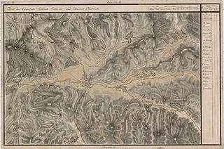
| Name shown on the map Nume din hartă |
Administrative unit Unitate administrativă |
Romanian name Numele românesc |
Hungarian name Numele unguresc |
German name Numele german |
Country today Ţara de astăzi |
|---|---|---|---|---|---|
| Magura | Kővár kerület Districtul Chioarului (vezi Ţara Chioarului) |
Măgureni | Nagyhegy | Romania | |
| Bretfalva vel Breben | Kővár kerület | Brebeni | Brébfalva | Romania | |
| Köpataka vel Kufoja | Belső-Szolnok megye ro:Comitatul Solnocul de Mijloc |
Cufoaia | Kohópatak | Romania | |
| Borkut | Belső-Szolnok megye | Borcut | Borkút | Romania | |
| Sztoikafalva | Belső-Szolnok megye | Stoiceni | Sztojkafalva | Romania | |
| Lapos Debrek | Belső-Szolnok megye | Dobricu Lăpuşului | Láposdebrek | Romania | |
| Libaton | Belső-Szolnok megye | Libotin | Libaton | Romania | |
| Kis Debretzen | Belső-Szolnok megye | Dumbrava | Kisdebrecen | Romania | |
| Matskamező | Belső-Szolnok megye | Răzoare | Macskamező | Romania | |
| Danpataka | Belső-Szolnok megye | Vălenii Lăpuşului | Dánpataka | Romania | |
| Disznopataka vel Pojana Porkuluj | Belső-Szolnok megye | Fântânele | Lápospataka | Romania | |
| Also Szőts | Belső-Szolnok megye | Suciu de Jos | Alsószőcs | Romania | |
| Rohi | Belső-Szolnok megye | Rohia | Rohi | Romania |
Summary
[edit]
| Description |
English: Grand Duchy of Transylvania, 1769-1773. Josephinische Landaufnahme pg.021 Română: Harta Iosefină a Transilvaniei, 1769-1773. Josephinische Landaufnahme pg.021 |
||||
| Date | between 1769 and 1773 | ||||
| Source | Österreichisches Staatsarchiv, Kriegsarchiv, B IX 715: Original-Aufnahmskarte des Grossfürtenthums Siebenbürgen. Geometrisch aufgenommen und bearbeitet in den Jahren 1769 bis 1773 unter der Direction des Obristen von Fabris, theils durch Officiere des grossen Feld-Generalstabes, theils auch von verschiedenen aus dem in Siebenbürgen bequartierten Regimentern zu diesem Geschäfte beigezogenen Individuen | ||||
| Author | Historische Militärkarte der österreichisch-ungarischen Monarchie | ||||
| Permission (Reusing this file) |
|
||||
Clickable Map of the Grand Duchy of Transylvania
[edit]
File history
Click on a date/time to view the file as it appeared at that time.
| Date/Time | Thumbnail | Dimensions | User | Comment | |
|---|---|---|---|---|---|
| current | 22:14, 3 December 2009 | | 8,468 × 5,612 (25.06 MB) | Asybaris01 (talk | contribs) | very good rez |
| 06:53, 21 October 2009 |  | 5,504 × 3,648 (17.12 MB) | Asybaris01 (talk | contribs) | {{Information |Description={{ro|1=Josephinische Landaufnahme pg21}} |Source=Josephinische Landaufnahme pg21 |Author=Asybaris01 |Date=10/21/2009 |Permission= |other_versions= }} |
You cannot overwrite this file.
File usage on Commons
There are no pages that use this file.
File usage on other wikis
The following other wikis use this file:
- Usage on hu.wikipedia.org
- Usage on ro.wikipedia.org