File:Josephinische Landaufnahme pg160.jpg
Jump to navigation
Jump to search

Size of this preview: 800 × 532 pixels. Other resolutions: 320 × 213 pixels | 640 × 425 pixels | 1,024 × 680 pixels | 1,280 × 851 pixels | 2,560 × 1,701 pixels | 8,421 × 5,596 pixels.
Original file (8,421 × 5,596 pixels, file size: 25.23 MB, MIME type: image/jpeg)
Captions
Captions
Add a one-line explanation of what this file represents
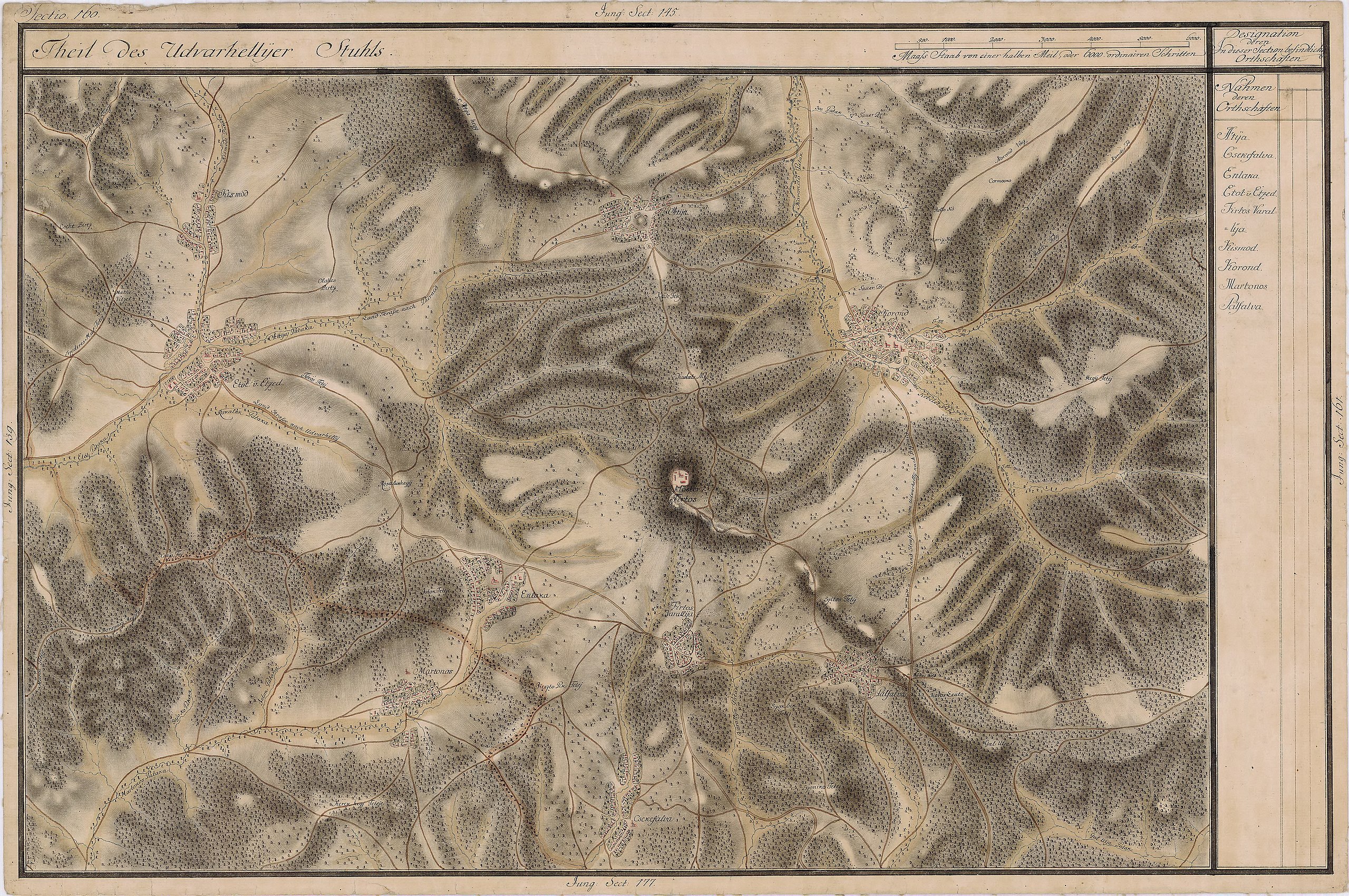
| Name shown on the map Nume din hartă |
Administrative unit Unitate administrativă |
Romanian name Numele românesc |
Hungarian name Numele unguresc |
German name Numele german |
Country today Ţara de astăzi |
|---|---|---|---|---|---|
| Kismód | Udvarhelyszék Scaunul Odorhei |
Cuşmed | Küsmöd | Romania | |
| Etöt v Etzed | Udvarhely szék | Atid | Etéd | Romania | |
| Atyha | Udvarhely szék | Atia | Atyha | Romania | |
| Korond | Udvarhely szék | Corund | Korond | Romania | |
| Palfalva | Udvarhely szék | Păuleni | Székelypálfalva | Romania | |
| Firtos Varallya | Udvarhely szék | Firtuşu | Firtosváralja | Romania | |
| Csehefalva | Udvarhely szék | Ceheţel | Csehétfalva | Romania | |
| Enlaka | Udvarhely szék | Inlăceni | Énlaka | Romania | |
| Martonos | Udvarhely szék | Firtănuş | Firtosmartonos | Romania |
Summary[edit]
| Description |
English: Grand Duchy of Transylvania, 1769-1773. Josephinische Landaufnahme pg.160 Română: Harta Iosefină a Transilvaniei, 1769-1773. Josephinische Landaufnahme pg.160 |
||||
| Date | between 1769 and 1773 | ||||
| Source | Österreichisches Staatsarchiv, Kriegsarchiv, B IX 715: Original-Aufnahmskarte des Grossfürtenthums Siebenbürgen. Geometrisch aufgenommen und bearbeitet in den Jahren 1769 bis 1773 unter der Direction des Obristen von Fabris, theils durch Officiere des grossen Feld-Generalstabes, theils auch von verschiedenen aus dem in Siebenbürgen bequartierten Regimentern zu diesem Geschäfte beigezogenen Individuen | ||||
| Author | Historische Militärkarte der österreichisch-ungarischen Monarchie | ||||
| Permission (Reusing this file) |
|
||||
Clickable Map of the Grand Duchy of Transylvania[edit]
File history
Click on a date/time to view the file as it appeared at that time.
| Date/Time | Thumbnail | Dimensions | User | Comment | |
|---|---|---|---|---|---|
| current | 07:13, 8 December 2009 | | 8,421 × 5,596 (25.23 MB) | Asybaris01 (talk | contribs) | good rezolution |
| 07:43, 4 November 2009 |  | 5,474 × 3,637 (17.28 MB) | Asybaris01 (talk | contribs) | {{Information |Description={{ro|1=Josephinische Landaufnahme pg160}} |Source=Josephinische Landaufnahme pg160 |Author=Asybaris01 |Date=2009/11/04 |Permission= |other_versions= }} |
You cannot overwrite this file.
File usage on Commons
There are no pages that use this file.
File usage on other wikis
The following other wikis use this file:
- Usage on arz.wikipedia.org
- Usage on en.wikipedia.org
- Usage on hu.wikipedia.org
- Usage on ro.wikipedia.org
- Usage on tt.wikipedia.org
- Usage on www.wikidata.org