File:Josephinische Landaufnahme pg242.jpg
Jump to navigation
Jump to search

Size of this preview: 800 × 529 pixels. Other resolutions: 320 × 212 pixels | 640 × 423 pixels | 1,024 × 677 pixels | 1,280 × 847 pixels | 2,560 × 1,693 pixels | 8,403 × 5,558 pixels.
Original file (8,403 × 5,558 pixels, file size: 24.81 MB, MIME type: image/jpeg)
Captions
Captions
Add a one-line explanation of what this file represents
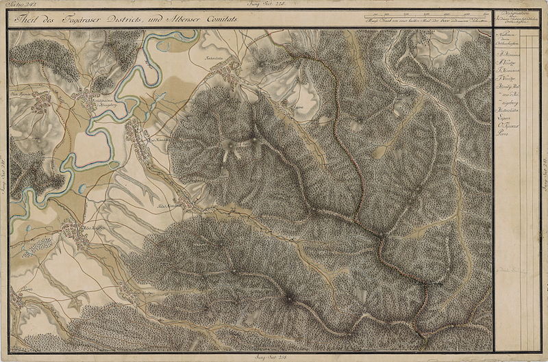
| Name shown on the map Nume din hartă |
Administrative unit Unitate administrativă |
Romanian name Numele românesc |
Hungarian name Numele unguresc |
German name Numele german |
Country today Ţara de astăzi |
|---|---|---|---|---|---|
| Kutsula | Fogaras kerület Komitat Fogarasch Districtul Făgăraş |
Cuciulata | Kucsuláta | Romania | |
| Királyhalma v Kõnigsberg | Fehér megye Unterweißenburger Komitat Comitatul Alba de Jos |
Crihalma | Királyhalma | Königsberg | Romania |
| Olah Tyukos | Kõhalom szék Repser Stuhl Scaunul Rupea |
Ticuşu Nou | Felsõtyúkos | Konradsdorf [in Altland, Königsboden] | Romania |
| Alsó Komána | Fogaras kerület | Comana de Jos | Alsókomána | Komondjen | Romania |
| Alsó Venitze | Fogaras kerület | Veneţia de Jos | Alsóvenice | Unter-Wenitze, Unter-Venedig | Romania |
| Felsó Komána | Fogaras kerület | Comana de Sus | Felsõkomána | Romania | |
| Felsó Venitze | Fogaras kerület | Veneţia de Sus | Felsõvenice | Ober-Wenitze, Ober-Venedig | Romania |
| Lupsa | Fogaras kerület | Lupşa | Lupsa | Lupscha, Wolfsdorf | Romania |
| Parró | Fogaras kerület | Părău | Páró | Berau | Romania |
Summary
[edit]
| Description |
English: Grand Duchy of Transylvania, 1769-1773. Josephinische Landaufnahme pg.242 Română: Harta Iosefină a Transilvaniei, 1769-1773. Josephinische Landaufnahme pg.242 |
||||
| Date | between 1769 and 1773 | ||||
| Source | Österreichisches Staatsarchiv, Kriegsarchiv, B IX 715: Original-Aufnahmskarte des Grossfürtenthums Siebenbürgen. Geometrisch aufgenommen und bearbeitet in den Jahren 1769 bis 1773 unter der Direction des Obristen von Fabris, theils durch Officiere des grossen Feld-Generalstabes, theils auch von verschiedenen aus dem in Siebenbürgen bequartierten Regimentern zu diesem Geschäfte beigezogenen Individuen | ||||
| Author | Historische Militärkarte der österreichisch-ungarischen Monarchie | ||||
| Permission (Reusing this file) |
|
||||
Clickable Map of the Grand Duchy of Transylvania
[edit]
File history
Click on a date/time to view the file as it appeared at that time.
| Date/Time | Thumbnail | Dimensions | User | Comment | |
|---|---|---|---|---|---|
| current | 18:31, 28 December 2009 | | 8,403 × 5,558 (24.81 MB) | Asybaris01 (talk | contribs) | new rez |
| 14:28, 7 October 2009 |  | 5,462 × 3,613 (16.87 MB) | Asybaris01 (talk | contribs) | {{Information |Description={{ro|1=Josephinische Landaufnahme pg242}} |Source=Josephinische Landaufnahme pg242 |Author=Asybaris01 |Date=10/07/2009 |Permission= |other_versions= }} |
You cannot overwrite this file.
File usage on Commons
The following 3 pages use this file:
File usage on other wikis
The following other wikis use this file:
- Usage on arz.wikipedia.org
- Usage on en.wikipedia.org
- Usage on es.wikipedia.org
- Usage on fr.wikipedia.org
- Usage on hu.wikipedia.org
- Usage on ja.wikipedia.org
- Usage on ro.wikipedia.org
- Usage on tt.wikipedia.org
- Usage on www.wikidata.org
View more global usage of this file.