File:Juist2.jpg
Bước tới điều hướng
Bước tới tìm kiếm
Kích thước hình xem trước: 800×280 điểm ảnh. Độ phân giải khác: 320×112 điểm ảnh | 640×224 điểm ảnh | 1.405×492 điểm ảnh.
Tập tin gốc (1.405×492 điểm ảnh, kích thước tập tin: 356 kB, kiểu MIME: image/jpeg)
Chú thích
Chú thích
Ghi một dòng giải thích những gì có trong tập tin này
| Miêu tả |
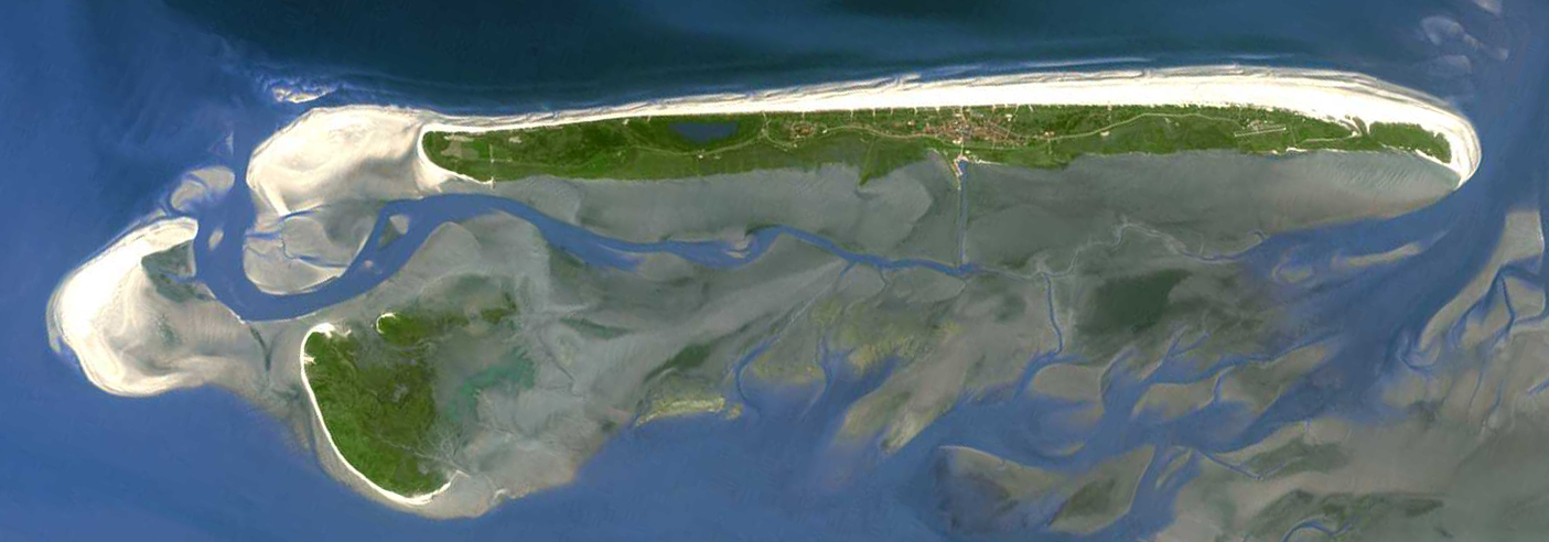
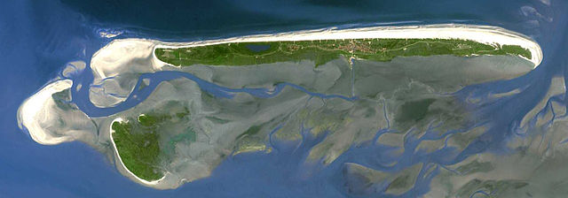
Deutsch: Insel Juist. Aufnahme von Landsat 7 (NASA) aus ca. 700 Kilometern Höhe. |
|||||
| Ngày | trước 2005 | |||||
| Nguồn gốc |
English: Transferred from de.wikipedia.org [1]: 13:53, 13. Jun 2005 . . Hoipoi . . 1405 x 492 (364780 Byte) – taken from NASA Landsat project (cf. Frisian Islands gallery at npoc.nl and borkum.jpg, so possibly it's a Terra/ASTER image) |
|||||
| Tác giả | NASA | |||||
| Giấy phép (Dùng lại tập tin) |
|

![[1]](https://de.wikipedia.org/wiki/Datei:Juist2.jpg)
| Annotations | This image is annotated: View the annotations at Commons |
Lịch sử tập tin
Nhấn vào ngày/giờ để xem nội dung tập tin tại thời điểm đó.
| Ngày/Giờ | Hình xem trước | Kích cỡ | Thành viên | Miêu tả | |
|---|---|---|---|---|---|
| hiện tại | 05:11, ngày 9 tháng 3 năm 2006 | 1.405×492 (356 kB) | Überraschungsbilder (thảo luận | đóng góp) | *Insel Juist *Aufnahme von Landsat 7 (NASA) aus ca. 700 Kilometern Höhe. *Quelle: [http://landsat.usgs.gov/ NASA Landsat project] *first upload on de.wikipedia [http://de.wikipedia.org/wiki/Bild:Juist2.jpg] ''13:53, 13. Jun 2005 . . [[:de:Benutzer:Hoipo |
Bạn không được phép ghi đè tập tin này.
Trang sử dụng tập tin
Trang sau sử dụng tập tin này:
Sử dụng tập tin toàn cục
Những wiki sau đang sử dụng tập tin này:
- Trang sử dụng tại ar.wikipedia.org
- Trang sử dụng tại cs.wikipedia.org
- Trang sử dụng tại da.wikipedia.org
- Trang sử dụng tại de.wikipedia.org
- Ostfriesische Inseln
- Norderney
- Borkum
- Kachelotplate
- Wangerooge
- Spiekeroog
- Baltrum
- Langeoog
- Memmert
- Minsener Oog
- Mellum
- Lütje Hörn
- Bant (Insel)
- Vorlage:Navigationsleiste Ostfriesische Inseln
- Juist
- Liste der Städte und Gemeinden in Ostfriesland
- Liste der Gemeinden im Landkreis Aurich
- Brauerplate
- Wikipedia:Kartenwerkstatt/Archiv/2011-07
- Trang sử dụng tại en.wikipedia.org
- Trang sử dụng tại eo.wikipedia.org
- Trang sử dụng tại es.wikipedia.org
- Trang sử dụng tại fr.wikipedia.org
- Trang sử dụng tại fy.wikipedia.org
- Trang sử dụng tại it.wikipedia.org
- Trang sử dụng tại ka.wikipedia.org
- Trang sử dụng tại mk.wikipedia.org
- Trang sử dụng tại nds.wikipedia.org
- Trang sử dụng tại nl.wikipedia.org
- Trang sử dụng tại nn.wikipedia.org
- Trang sử dụng tại stq.wikipedia.org
- Trang sử dụng tại sv.wikipedia.org
- Trang sử dụng tại uk.wikipedia.org
- Trang sử dụng tại vi.wikipedia.org
- Trang sử dụng tại xmf.wikipedia.org