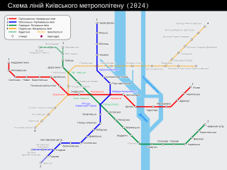
File:Kyiv metro route map uk.svg
Vai alla navigazione
Vai alla ricerca

Dimensioni di questa anteprima PNG per questo file SVG: 800 × 598 pixel. Altre risoluzioni: 320 × 239 pixel | 640 × 478 pixel | 1 024 × 766 pixel | 1 280 × 957 pixel | 2 560 × 1 914 pixel | 1 030 × 770 pixel.
File originale (file in formato SVG, dimensioni nominali 1 030 × 770 pixel, dimensione del file: 30 KB)
Didascalie
Didascalie
Aggiungi una brevissima spiegazione di ciò che questo file rappresenta
| Descrizione |
|
||
| Data | |||
| Fonte | Opera propria (Testo originale: self-made by Sameboat ) | ||
| Autore | Sameboat; some corrections made by Anatoliy Honcharov & AMY | ||
| Licenza (Riusare questo file) |
|
||
| Altre versioni |
|
||
| SVG sviluppo | Questa mappa in grafica vettoriale è stata creata con Inkscape. |
Cronologia del file
Fare clic su un gruppo data/ora per vedere il file come si presentava nel momento indicato.
| Data/Ora | Miniatura | Dimensioni | Utente | Commento | |
|---|---|---|---|---|---|
| attuale | 11:24, 5 giu 2019 | | 1 030 × 770 (30 KB) | Minorax (discussione | contributi) | validate // Editing SVG source code using User:Rillke/SVGedit.js; upload handled by User:Rillke/MwJSBot.js |
| 11:23, 5 giu 2019 |  | 1 030 × 770 (30 KB) | Gzhegozh (discussione | contributi) | Солом'янська площа: виправлено | |
| 11:20, 5 giu 2019 |  | 1 030 × 770 (30 KB) | Gzhegozh (discussione | contributi) | minor fixes: 2nd metro line name updated; typos, distances between stations and their names fixed | |
| 17:32, 5 nov 2018 |  | 1 030 × 770 (20 KB) | Sebastian Wallroth (discussione | contributi) | code cleanup | |
| 06:01, 4 mag 2018 |  | 1 030 × 770 (24 KB) | AMY 81-412 (discussione | contributi) | 2018 Почайна, вул. Луценка Сховав Лівобережну лінію Уточнення в районі Виноградара, Троєщини Усе згідно зі схемою http://metro.sashman.kiev.ua/scheme/ ( http://archive.li/Bxb6U ) | |
| 10:38, 6 nov 2013 |  | 1 030 × 770 (22 KB) | AMY 81-412 (discussione | contributi) | fixed 2013 | |
| 10:32, 6 nov 2013 |  | 1 030 × 770 (22 KB) | AMY 81-412 (discussione | contributi) | +Teremky | |
| 14:40, 24 ott 2012 |  | 1 030 × 770 (22 KB) | AMY 81-412 (discussione | contributi) | + Ipodrom | |
| 07:15, 27 dic 2011 |  | 1 030 × 770 (22 KB) | AMY 81-412 (discussione | contributi) | update + Vystavkovyi Tsentr | |
| 13:38, 7 set 2011 |  | 1 030 × 770 (22 KB) | AMY 81-412 (discussione | contributi) | update |
Impossibile sovrascrivere questo file.
Utilizzo del file
Le seguenti 14 pagine usano questo file:
- User:Chumwa/OgreBot/Potential transport maps/2018 May 1-10
- User:Chumwa/OgreBot/Potential transport maps/2018 November 1-10
- User:Chumwa/OgreBot/Potential transport maps/2019 June 1-10
- User:Chumwa/OgreBot/Public transport information/2018 May 1-10
- User:Chumwa/OgreBot/Public transport information/2018 November 1-10
- User:Chumwa/OgreBot/Public transport information/2019 June 1-10
- User:Chumwa/OgreBot/Transport Maps/2018 May 1-10
- User:Chumwa/OgreBot/Transport Maps/2018 November 1-10
- User:Chumwa/OgreBot/Transport Maps/2019 June 1-10
- User:Chumwa/OgreBot/Travel and communication maps/2018 May 1-10
- User:Chumwa/OgreBot/Travel and communication maps/2018 November 1-10
- User:Chumwa/OgreBot/Travel and communication maps/2019 June 1-10
- File:Kiev metro route map uk.svg (reindirizzamento file)
- File:Схема Київського метро станом на 01.08.2018.jpg (reindirizzamento file)
Utilizzo globale del file
Anche i seguenti wiki usano questo file:
- Usato nelle seguenti pagine di hu.wikipedia.org:
- Usato nelle seguenti pagine di hy.wikipedia.org:
- Usato nelle seguenti pagine di it.wikipedia.org:
- Usato nelle seguenti pagine di uk.wikipedia.org:
- Usato nelle seguenti pagine di vec.wikipedia.org: