File:Kyiv regions.svg
Jump to navigation
Jump to search

Size of this PNG preview of this SVG file: 330 × 414 pixels. Other resolutions: 191 × 240 pixels | 383 × 480 pixels | 612 × 768 pixels | 816 × 1,024 pixels | 1,632 × 2,048 pixels.
Original file (SVG file, nominally 330 × 414 pixels, file size: 449 KB)
Captions
Captions
Add a one-line explanation of what this file represents
| Description |
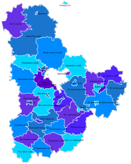
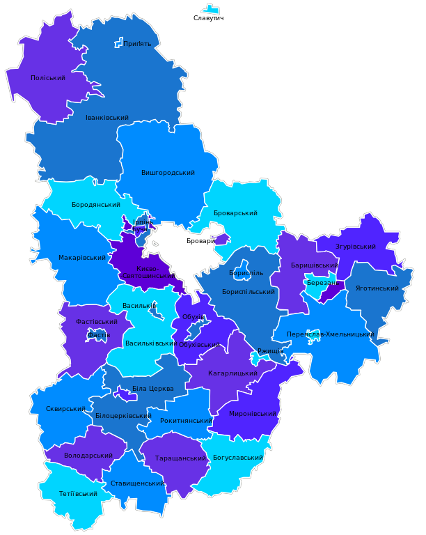
Українська: Kyiv_regions.svg: Карта-схема районів Київської області |
| Date | |
| Source | Own work |
| Author | Artemco |
| Permission (Reusing this file) |
This file is licensed under the Creative Commons Attribution-Share Alike 3.0 Unported license.
|
Original upload log[edit]
The original description page was here. All following user names refer to uk.wikipedia.
- 2012-06-04 16:52 Texnik 761×952× (601010 bytes) {{Зображення|Назва=Kyiv_regions.svg|Опис=Карта-схема районів Київської області|Автор=Катерина Ткачова ([[Користувач:Kaha]])|Джерело=власна робота|...
- 2009-01-20 10:46 VictorAnyakin 761×952× (690014 bytes) {{Зображення|Назва=Kyiv_regions.svg|Опис=Карта-схема районів Київської області|Автор=Катерина Ткачова ([[Користувач:Kaha]])|Джерело=власна робота|Ч�
File history
Click on a date/time to view the file as it appeared at that time.
| Date/Time | Thumbnail | Dimensions | User | Comment | |
|---|---|---|---|---|---|
| current | 19:48, 17 August 2015 | | 330 × 414 (449 KB) | Artemco (talk | contribs) | уточнены границы, добавлены города областного подчинения |
| 16:46, 26 January 2013 |  | 761 × 952 (584 KB) | Ahonc (talk | contribs) | fix Києво-Святошинський | |
| 11:32, 25 January 2013 |  | 761 × 952 (587 KB) | BaseBot (talk | contribs) | automatted transfer from ukwikip using BaseSat's program |
You cannot overwrite this file.
File usage on Commons
The following 22 pages use this file:
- Category:Architecture in Kyiv Oblast
- Category:Births in Kyiv Oblast
- Category:Bodies of water in Kyiv Oblast
- Category:Culture of Kyiv Oblast
- Category:Deaths in Kyiv Oblast
- Category:Geography of Kyiv Oblast
- Category:History of Kyiv Oblast
- Category:Kyiv Oblast
- Category:Kyiv Oblast by year
- Category:Lakes in Kyiv Oblast
- Category:Libraries in Kyiv Oblast
- Category:Maps of Kyiv Oblast
- Category:People of Kyiv Oblast
- Category:Populated places in Kyiv Oblast
- Category:Raions of Kyiv Oblast
- Category:Rivers of Kyiv Oblast
- Category:Roads in Kyiv Oblast
- Category:Rural settlements in Kyiv Oblast
- Category:Sports in Kyiv Oblast
- Category:Stadiums in Kyiv Oblast
- Category:Views of Kyiv Oblast
- Category:Villages in Kyiv Oblast
File usage on other wikis
The following other wikis use this file:
- Usage on ba.wikipedia.org
- Usage on be.wikipedia.org
- Usage on bg.wikipedia.org
- Usage on da.wikipedia.org
- Usage on en.wikipedia.org
- Usage on ja.wikipedia.org
- Usage on kk.wikipedia.org
- Usage on pl.wikivoyage.org
- Usage on pt.wikipedia.org
- Usage on ro.wikipedia.org
- Usage on ru.wikipedia.org
- Usage on tt.wikipedia.org
- Usage on uk.wikipedia.org
- Обговорення:Згурівка
- Обговорення:Олененко Юрій Олександрович
- Обговорення:Васильків
- Обговорення:Богданівка (Броварський район)
- Обговорення:Білогородка (Бучанський район)
- Обговорення:Гавронщина
- Обговорення:Ірпінь
- Обговорення:Лютіж (Вишгородський район)
- Обговорення:Ніжиловичі
- Шаблон:Kyiv Oblast-week-new
- Шаблон:Kyiv Oblast-week-improve
- Обговорення:Рудня-Грезлянська
- Обговорення:Ірпінський історико-краєзнавчий музей
- Обговорення:Автошлях Р 01
- Обговорення:Кравченко Андрій Григорович
- Обговорення:Потіївка (колійний пост)
- Обговорення:Церква Святителя Миколая (Ірпінь)
- Обговорення:Перун (кінотеатр)
- Обговорення:Покровська церква (Нові Петрівці)
- Обговорення:Коваленко Григорій Олексійович
- Обговорення:Кваша Дмитро Михайлович
- Обговорення:Новик Микола Петрович
- Обговорення:Таран Людмила Василівна
- Обговорення:Котлярський Борис Моїсейович
- Обговорення:Історія Макарова
- Обговорення:Синявка (притока Росави)
- Обговорення:Коцур Віктор Петрович
- Обговорення:Макарів
- Обговорення:Герб Макарова
- Обговорення:Комісаренко Василь Павлович
- Обговорення:Макарівські вісті
- Обговорення:Буряківка (Іванківський район)
- Обговорення:Стечанка
- Обговорення:Варовичі (Поліський район)
- Обговорення:Пам'ятники Фастова
- Обговорення:Кожанка (селище)
- Обговорення:Покровська церква (Кожанка)
- Обговорення:Древецький Анатолій Анатолійович
View more global usage of this file.