File:LA2-Bergslagen-vatten.png
Jump to navigation
Jump to search

Size of this preview: 527 × 599 pixels. Other resolutions: 211 × 240 pixels | 422 × 480 pixels | 938 × 1,066 pixels.
Original file (938 × 1,066 pixels, file size: 211 KB, MIME type: image/png)
Captions
Captions
Add a one-line explanation of what this file represents

|
This map image could be re-created using vector graphics as an SVG file. This has several advantages; see Commons:Media for cleanup for more information. If an SVG form of this image is available, please upload it and afterwards replace this template with
{{vector version available|new image name}}.
It is recommended to name the SVG file “LA2-Bergslagen-vatten.svg”—then the template Vector version available (or Vva) does not need the new image name parameter. |
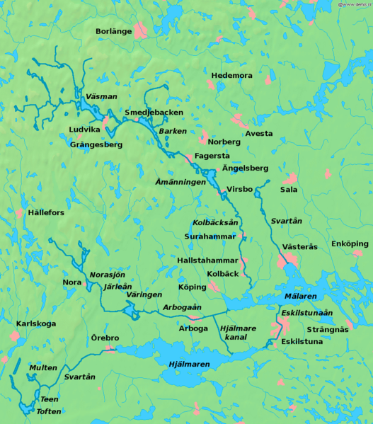
| Description | Map of lakes and rivers in south central Sweden, the Bergslagen region. Bounding box West 14.4°, South 59°, East 17.2°, North 60.6°. Center at 59°48′00″N 15°48′00″E / 59.80000°N 15.80000°E. | ||||
| Date | |||||
| Source | Background map from the Demis map server, rivers enhanced and names added by user:LA2. | ||||
| Author | Background map from the Demis map server, rivers enhanced and names added by user:LA2. | ||||
| Permission (Reusing this file) |
|
File history
Click on a date/time to view the file as it appeared at that time.
| Date/Time | Thumbnail | Dimensions | User | Comment | |
|---|---|---|---|---|---|
| current | 21:31, 2 May 2008 | | 938 × 1,066 (211 KB) | LA2 (talk | contribs) | {{Information |Description=Map of lakes and rivers in south central Sweden, the Bergslagen region. Bounding box West 14.4°, South 59°, East 17.2°, North 60.6°. Center at {{coor d|59.80000|N|15.80000|E|scale:960000}}. |Source=Background map from th |
You cannot overwrite this file.
File usage on Commons
The following page uses this file:
File usage on other wikis
The following other wikis use this file:
- Usage on be.wikipedia.org
- Usage on cs.wikipedia.org
- Usage on da.wikipedia.org
- Usage on de.wikipedia.org
- Usage on en.wikipedia.org
- Usage on en.wikivoyage.org
- Usage on es.wikipedia.org
- Usage on fi.wikipedia.org
- Usage on fr.wikipedia.org
- Usage on he.wikipedia.org
- Usage on it.wikipedia.org
- Usage on nl.wikipedia.org
- Usage on nn.wikipedia.org
- Usage on no.wikipedia.org
- Usage on pl.wikipedia.org
- Usage on pt.wikipedia.org
- Usage on ru.wikipedia.org
- Usage on sh.wikipedia.org
- Usage on sv.wikipedia.org
View more global usage of this file.