File:Lewis&ClarkBridgeSP.jpg
Tập tin gốc (4.593×1.200 điểm ảnh, kích thước tập tin: 2,26 MB, kiểu MIME: image/jpeg)
Chú thích
Chú thích
Miêu tả
[sửa]| Miêu tả |
Deutsch: Die Lewis and Clark Bridge trägt Washington State Route 433 über den Lewis and Clark Bridge bei zwischen den Städten Longview, Washington und Rainier, Oregon. Shot aus der US Route 30 in Oregon nach Nordosten übernommen. Dies ist ein Stich von 4 Fotografien.
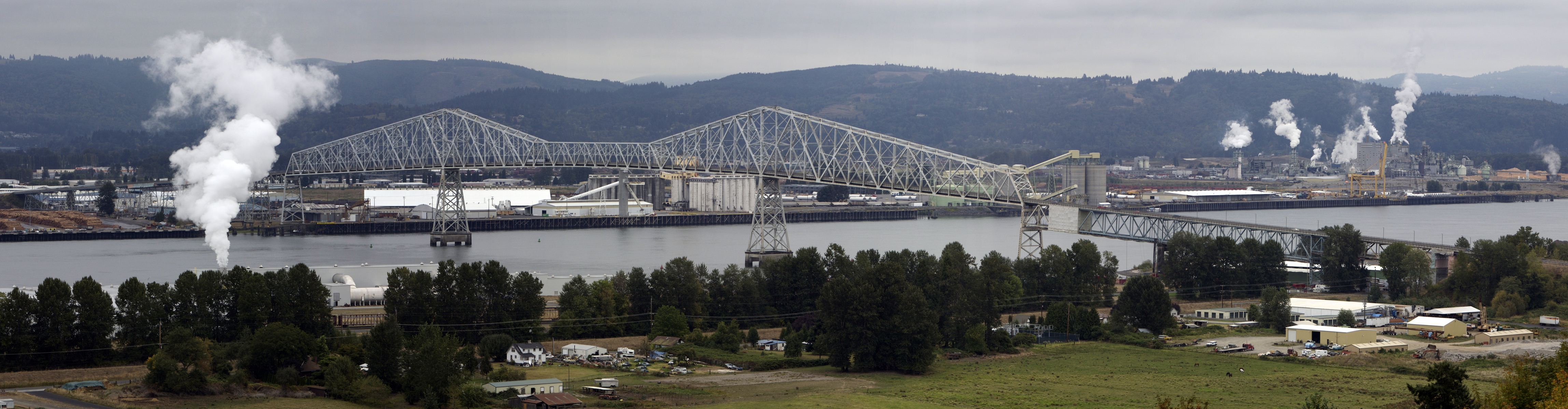
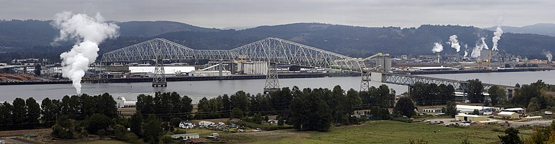
English: The Lewis and Clark Bridge carries Washington State Route 433 across the Columbia River at between the cities of Longview, Washington and Rainier, Oregon. Shot taken from U.S. Route 30 in Oregon looking northeast. This is a stitch of 4 exposures.
Français : Le pont Lewis et Clark permet à la Washington State Route 433 de traverser le fleuve Columbia entre les villes de Longview, Washington et Rainier, Oregon. Photo prise à partir de la US Route 30 dans l'Oregon en direction du nord-est. Cette photo est réalisée par assemblage de 4 clichés. |
||
| Ngày | |||
| Nguồn gốc | Tác phẩm được tạo bởi người tải lên | ||
| Tác giả | Cacophony | ||
| Giấy phép (Dùng lại tập tin) |
Tôi, người giữ bản quyền tác phẩm này, từ đây phát hành nó theo các giấy phép sau:
Tác phẩm này được phát hành theo giấy phép Creative Commons Ghi công–Chia sẻ tương tự, các phiên bản 3.0 Chưa chuyển đổi, 2.5 Chung, 2.0 Chung, và 1.0 Chung.
Bạn có thể chọn giấy phép mà bạn muốn. |

| Vị trí đối tượng | | Xem hình này và các hình ảnh lân cận trên: OpenStreetMap |
|---|
|

|
This image has been assessed under the valued image criteria and is considered the most valued image on Commons within the scope: Lewis and Clark Bridge. You can see its nomination here. |
Lịch sử tập tin
Nhấn vào ngày/giờ để xem nội dung tập tin tại thời điểm đó.
| Ngày/Giờ | Hình xem trước | Kích cỡ | Thành viên | Miêu tả | |
|---|---|---|---|---|---|
| hiện tại | 19:05, ngày 13 tháng 9 năm 2007 | 4.593×1.200 (2,26 MB) | Cacophony (thảo luận | đóng góp) | {{Information |Description=The Lewis and Clark Bridge across the Columbia River at Longview, Washington. Seen from the west along U.S. Highway 30. This is a stich of 4 exposures. |Source=self-made |Date=9/12/07 |Author= Cacophony }} |
Bạn không được phép ghi đè tập tin này.
Trang sử dụng tập tin
33 trang sau sử dụng tập tin này:
- User:Samsara/POTY 2011 overview
- User:Ö/Best/2011
- User talk:Admrboltz/Archive 1
- User talk:Cacophony
- Commons:Featured picture candidates/File:Lewis&ClarkBridgeSP.jpg
- Commons:Featured picture candidates/Log/February 2011
- Commons:Featured pictures/Places/Architecture/Bridges
- Commons:Featured pictures/Places/Panoramas
- Commons:Featured pictures/chronological/2011-A
- Commons:Files used on the AARoads Wiki/33
- Commons:Picture of the Year/2011/Galleries/2011-A
- Commons:Picture of the Year/2011/Galleries/A
- Commons:Picture of the Year/2011/Galleries/A/table
- Commons:Picture of the Year/2011/Galleries/ALL
- Commons:Picture of the Year/2011/Galleries/FEB
- Commons:Picture of the Year/2011/Galleries/Index/2
- Commons:Picture of the Year/2011/Galleries/Index/ALL
- Commons:Picture of the Year/2011/Galleries/Index/Panoramic views
- Commons:Picture of the Year/2011/Galleries/Panoramic views
- Commons:Picture of the Year/2011/Galleries/Panoramic views/Large
- Commons:Picture of the Year/2011/Galleries/Panoramic views/Small
- Commons:Picture of the Year/2011/Galleries/table
- Commons:Picture of the Year/2011/R1/Lewis&ClarkBridgeSP.jpg
- Commons:Picture of the Year/2011/Results/R1/ALL/table
- Commons:Picture of the Year/2011/Results/R1/Panoramic views
- Commons:Picture of the Year/2011/Results/R1/Panoramic views/table
- Commons:Quality images/Subject/Places/Mixed/Panorama/Archive 2008 to 2015
- Commons:Quality images candidates/Archives December 2010
- Commons:Valued image candidates/Lewis&ClarkBridgeSP.jpg
- Commons:Valued images by topic/Places/Buildings/Bridges
- Commons talk:Picture of the Year/2011/Results/R1/ALL/table
- Category:Lewis and Clark Bridge
- Category:Washington State Route 433
Sử dụng tập tin toàn cục
Những wiki sau đang sử dụng tập tin này:
- Trang sử dụng tại bn.wikipedia.org
- Trang sử dụng tại de.wikipedia.org
- Trang sử dụng tại en.wikipedia.org
- Lewis and Clark Bridge (Columbia River)
- Wikipedia:WikiProject Bridges and Tunnels
- List of crossings of the Columbia River
- List of longest cantilever bridge spans
- Washington State Route 433
- National Register of Historic Places listings in Columbia County, Oregon
- Wikipedia:Featured picture candidates/February-2011
- Wikipedia:Featured picture candidates/Lewis and Clark Bridge Panorama
- File talk:Lewis&ClarkBridgeSP.jpg
- User:Another Believer/Travel/United States
- Trang sử dụng tại es.wikipedia.org
- Trang sử dụng tại fr.wikipedia.org
- Trang sử dụng tại mg.wikipedia.org
- Trang sử dụng tại nl.wikipedia.org
- Trang sử dụng tại pl.wikipedia.org
- Trang sử dụng tại vi.wikipedia.org
- Trang sử dụng tại www.wikidata.org