File:Map Crusader states 1102-fr.svg

File originale (file in formato SVG, dimensioni nominali 591 × 690 pixel, dimensione del file: 118 KB)
Didascalie
Didascalie
Dettagli[modifica]
| Descrizione |
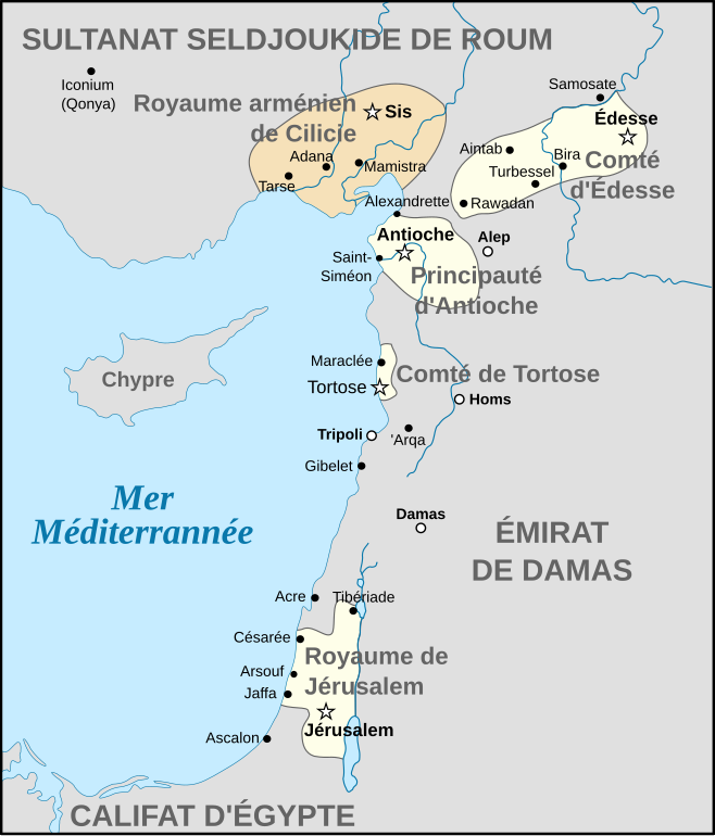
Français : Carte politique du Proche-Orient en 1102, juste après la Première Croisade. |
| Data | |
| Fonte | Opera propria |
| Autore | Odejea |
| Altre versioni |
Other related versions: []
See also[modifica]Opere derivate da questo file: Map Crusader states 1102-es.svg |


|
Questo file SVG contiene del testo che può essere facilmente tradotto nella tua lingua, utilizzando un editor che supporta SVG (ad esempio un editor XML o di testo). Per maggiori informazioni vedi: Tradurre un file SVG. |
This file is translated using SVG For most Wikipedia projects, you can embed the file normally (without a To translate the text into your language, you can use the SVG Translate tool. Alternatively, you can download the file to your computer, add your translations using whatever software you're familiar with, and re-upload it with the same name. You will find help in Graphics Lab if you're not sure how to do this. |
Licenza[modifica]

|
È permesso copiare, distribuire e/o modificare questo documento in base ai termini della GNU Free Documentation License, Versione 1.2 o successive pubblicata dalla Free Software Foundation; senza alcuna sezione non modificabile, senza testo di copertina e senza testo di quarta di copertina. Una copia della licenza è inclusa nella sezione intitolata Testo della GNU Free Documentation License. |
- Tu sei libero:
- di condividere – di copiare, distribuire e trasmettere quest'opera
- di modificare – di adattare l'opera
- Alle seguenti condizioni:
- attribuzione – Devi fornire i crediti appropriati, un collegamento alla licenza e indicare se sono state apportate modifiche. Puoi farlo in qualsiasi modo ragionevole, ma non in alcun modo che suggerisca che il licenziante approvi te o il tuo uso.
- condividi allo stesso modo – Se remixi, trasformi o sviluppi il materiale, devi distribuire i tuoi contributi in base alla stessa licenza o compatibile all'originale.
Cronologia del file
Fare clic su un gruppo data/ora per vedere il file come si presentava nel momento indicato.
| Data/Ora | Miniatura | Dimensioni | Utente | Commento | |
|---|---|---|---|---|---|
| attuale | 10:24, 10 feb 2024 | | 591 × 690 (118 KB) | Leptictidium (discussione | contributi) | File uploaded using svgtranslate tool (https://svgtranslate.toolforge.org/). Added translation for ca. |
| 13:29, 8 feb 2024 |  | 591 × 690 (118 KB) | Manlleus (discussione | contributi) | added catalan language | |
| 21:41, 23 mag 2021 |  | 591 × 690 (82 KB) | Akeosnhaoe (discussione | contributi) | moved "Comté de Tortose" to where it was supposed to be | |
| 15:20, 28 ago 2015 |  | 591 × 690 (82 KB) | Bibi Saint-Pol (discussione | contributi) | ||
| 15:19, 28 ago 2015 |  | 591 × 690 (82 KB) | Bibi Saint-Pol (discussione | contributi) | use standard colors + texts as SVG element | |
| 23:20, 1 giu 2008 |  | 591 × 690 (621 KB) | Odejea (discussione | contributi) | bleu | |
| 21:14, 28 mag 2008 |  | 591 × 690 (621 KB) | Odejea (discussione | contributi) | {{Information |Description= |Source= |Author= |Date= |Permission= |other_versions= }} {{ImageUpload|full}} | |
| 21:11, 28 mag 2008 |  | 591 × 690 (580 KB) | Odejea (discussione | contributi) | {{Information |Description= |Source= |Author= |Date= |Permission= |other_versions= }} {{ImageUpload|full}} | |
| 21:06, 28 mag 2008 |  | 591 × 690 (516 KB) | Odejea (discussione | contributi) | {{Information |Description= |Source= |Author= |Date= |Permission= |other_versions= }} {{ImageUpload|full}} | |
| 21:03, 28 mag 2008 |  | 591 × 690 (407 KB) | Odejea (discussione | contributi) | {{Information |Description= |Source= |Author= |Date= |Permission= |other_versions= }} {{ImageUpload|full}} |
Impossibile sovrascrivere questo file.
Utilizzo del file
Le seguenti 14 pagine usano questo file:
- User:Geagea/Israel/2015 August 28
- User:Magog the Ogre/Multilingual legend/2021 May 21-31
- User:Magog the Ogre/Multilingual legend/2024 February 10-14
- User:Magog the Ogre/Multilingual legend/2024 February 5-9
- File:Levant 1102-fr.svg (reindirizzamento file)
- File:Map Crusader states 1102-en.svg
- File:Map Crusader states 1102-es.svg
- File:Map Crusader states 1102-fr.svg
- File:Map Crusader states 1102-hu.svg
- File:Map Crusader states 1102-it.svg
- File:Map Crusader states 1102-pt.svg
- File:Map Crusader states 1102-ru.svg
- Template:Other versions/Map Crusader states 1102
Utilizzo globale del file
Anche i seguenti wiki usano questo file:
- Usato nelle seguenti pagine di ca.wikipedia.org:
- Usato nelle seguenti pagine di fr.wikipedia.org:
- Usato nelle seguenti pagine di hr.wikipedia.org:
- Usato nelle seguenti pagine di it.wikipedia.org:
- Usato nelle seguenti pagine di no.wikipedia.org:
- Usato nelle seguenti pagine di oc.wikipedia.org:
- Usato nelle seguenti pagine di ro.wikipedia.org:
- Usato nelle seguenti pagine di uk.wikipedia.org:
Metadati
- Maps showing 12th-century history
- Maps of the history of the Middle East
- Maps of the crusades
- Maps of the Kingdom of Jerusalem
- Maps of the County of Tripoli
- Maps of the Principality of Antioch
- Maps of Cilicia
- Maps of the County of Edessa
- Maps of the history of Cyprus
- Maps of the history of the Levant
- French-language SVG maps showing history
- Catalan-language SVG maps showing history