File:Map France 1477-fr.svg

File originale (file in formato SVG, dimensioni nominali 900 × 970 pixel, dimensione del file: 1,16 MB)
Didascalie
Didascalie
Legends
[modifica]Français : Légende
[modifica]English: Legend
[modifica]|
Red line: Boundary of the Kingdom of France
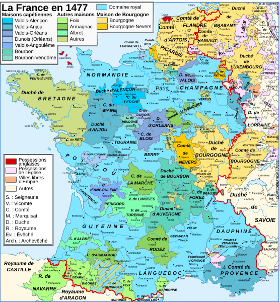
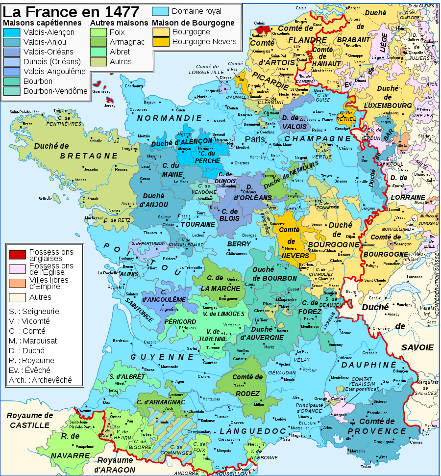
Capetian houses (Valois, Bourbon) : Valois-Alençon (René of Alençon) :
— Duchy of Alençon (1220) — County of Perche (1227) Valois-Anjou (René I the Good) :
— Duchy of Anjou (1204) — County of Provence (1498) — Duchy of Bar (1766) — County of Maine (1204) — County of Guise (1688) — County of Gien (1199) — Viscounty of Châtellerault (1482) Valois-Orléans (Louis XII of France) :
— Duchy of Orléans (987) — Duchy of Valois (1214) Orléans-Dunois (François d'Orléans-Longueville, son of Jean de Dunois) :
— County of Dunois (1707) — County of Longueville (13th century) — Lordship of Parthenay (1419) Valois-Angoulême (Charles d'Orléans) :
— County of Angoulême (1308) Bourbon (John II, Duke of Bourbon) :
— Duchy of Bourbon (1531) — Duchy of Auvergne (v. 1200) — County of Forez (1531) — County of Clermont-en-Beauvaisis (1218) — Lordship of Beaujeu (1531) |
Other houses :
House of Burgundy : House of Burgundy (Charles the Rash) :
— Duchy of Burgundy (1016) — County of Charolais (1751) — Sundgau (1648) — Picardy (12-13th centuries) — County of Artois (1185) — County of Hainaut (1659, 1678) — County of Flanders (1678) — Duchy of Brabant (-) — Duchy of Guelders (-) House of Bourgogne-Nevers (John II of Burgundy-Nevers) :
— County of Nevers (?) — County of Rethel (?) — County of Eu (?)
House of Foix (Francis Phoebus) :
— County of Foix (1589) — County of Bigorre (1322) — Viscounty of Béarn (1589) — Kingdom of Navarre (1589) — Co-Princes of Andorra (-) John of Foix-Étampes, brother of Francis Phoebus : — Viscount of Narbonne (1507) House of Armagnac (Charles I of Armagnac) :
— County of Armagnac (1589) — County of Rodez (1589) — County of Marche (1531) — Duchy of Nemours (1274) House of Albret (Alain d'Albret) :
— Lordship of Albret (1589) — Viscounty of Limoges (1589) — County of Périgord (1589)
Various houses :
House of Brittany (Francis II, Duke of Brittany) : — Duchy of Brittany (1532) — County of Vertus (1284?) House of Montpensier (Louis I, Count of Montpensier, count of Montpensier et dauphin of Auvergne) : — County of Sancerre (1234) House of Chalon (John of Chalon-d'Arlay) : — Principality of Orange (1673) House of Husson-Tonnerre (Charles de Husson) : — County of Tonnerre (?) House of Lorraine (René II, Duke of Lorraine) : — County of Aumale (1194) ? |
|
Lands outside of the kingdom :
— County of Roussillon (1659) — Duchy of Savoy (Bresse, Bugey, Gex : 1601, Savoy : 1860) — Duchy of Lorraine (1766) — Principality of Montbéliard (1793) — County of Blâmont (1766) — Principality of Salm (1793) Ecclesiastical States :
— Comtat Venaissin, Avignon (Papal States) (1791) — Metz, Verdun and Toul (1552-1648) — Cambrai (1678) English possessions
(1589) : year of the first union to royal lands |
Legenda em português
[modifica]|
Linha Vermelha:Fronteiras do Reino da França
Valois-Alençon (René of Alençon)
— Duque de Alençon (1220) — Condes de Perche (1227) Valois-Anjou (O bom rei de Nápoles) :
— Duque de Anjou (1204) — Condes de Provença (1498) — Duque de Bar (1766) — Condes de Maine (1204) — Condes de Guise (1688) — Condes de Gien (1199) — Viscondes de Châtellerault (1482) Valois-Orléans (Luís XII de França) :
— Duque d'Orleães (987) — Duchy of Valois (1214) Orléans-Dunois (François d'Orléans-Longueville, son of Jean de Dunois) :
— County of Dunois (1707) — County of Longueville (13th century) — Lordship of Parthenay (1419) Valois-Angoulême (Charles d'Orléans) :
— County of Angoulême (1308) Bourbon (John II, Duke of Bourbon) :
— Duchy of Bourbon (1531) — Duchy of Auvergne (v. 1200) — County of Forez (1531) — County of Clermont-en-Beauvaisis (1218) — Lordship of Beaujeu (1531) |
Other houses :
House of Burgundy : House of Burgundy (Charles the Rash) :
— Duchy of Burgundy (1016) — County of Charolais (1751) — Sundgau (1648) — Picardy (12-13th centuries) — County of Artois (1185) — County of Hainaut (1659, 1678) — County of Flanders (1678) — Duchy of Brabant (-) — Duchy of Guelders (-) House of Bourgogne-Nevers (John II of Burgundy-Nevers) :
— County of Nevers (?) — County of Rethel (?) — County of Eu (?)
House of Foix (Francis Phoebus) :
— County of Foix (1589) — County of Bigorre (1322) — Viscounty of Béarn (1589) — Kingdom of Navarre (1589) — Co-Princes of Andorra (-) John of Foix-Étampes, brother of Francis Phoebus : — Viscount of Narbonne (1507) House of Armagnac (Charles I of Armagnac) :
— County of Armagnac (1589) — County of Rodez (1589) — County of Marche (1531) — Duchy of Nemours (1274) House of Albret (Alain d'Albret) :
— Lordship of Albret (1589) — Viscounty of Limoges (1589) — County of Périgord (1589)
Various houses :
House of Brittany (Francis II, Duke of Brittany) : — Duchy of Brittany (1532) — County of Vertus (1284?) House of Montpensier (Louis I, Count of Montpensier, count of Montpensier et dauphin of Auvergne) : — County of Sancerre (1234) House of Chalon (John of Chalon-d'Arlay) : — Principality of Orange (1673) House of Husson-Tonnerre (Charles de Husson) : — County of Tonnerre (?) House of Lorraine (René II, Duke of Lorraine) : — County of Aumale (1194) ? |
|
Lands outside of the kingdom :
— County of Roussillon (1659) — Duchy of Savoy (Bresse, Bugey, Gex : 1601, Savoy : 1860) — Duchy of Lorraine (1766) — Principality of Montbéliard (1793) — County of Blâmont (1766) — Principality of Salm (1793) Ecclesiastical States :
— Comtat Venaissin, Avignon (Papal States) (1791) — Metz, Verdun and Toul (1552-1648) — Cambrai (1678) English possessions
(1589) : year of the first union to royal lands |
Dettagli
[modifica]| Descrizione |
English: Map of France in 1477.
Français : Carte de la France en 1477. |
||||||||
| Data | |||||||||
| Fonte |
English: Opera propria. Image renamed from Image:Map France History XVe.svg. Data:
Français : Création personnelle. Image renommée depuis Image:Map France History XVe.svg. Données :
|
||||||||
| Autore | Zigeuner | ||||||||
| Licenza (Riusare questo file) |
Io, detentore del copyright su quest'opera, dichiaro di pubblicarla con le seguenti licenze:
Questo file è disponibile in base alla licenza Creative Commons Attribuzione-Condividi allo stesso modo 2.5 Generico
Puoi scegliere la licenza che preferisci. |
||||||||
| Altre versioni |
Opere derivate da questo file: Map France 1477-de.svg
[]
|


|
Questo file SVG contiene del testo che può essere facilmente tradotto nella tua lingua, utilizzando un editor che supporta SVG (ad esempio un editor XML o di testo). Per maggiori informazioni vedi: Tradurre un file SVG. |
Cronologia del file
Fare clic su un gruppo data/ora per vedere il file come si presentava nel momento indicato.
| Data/Ora | Miniatura | Dimensioni | Utente | Commento | |
|---|---|---|---|---|---|
| attuale | 16:29, 14 mar 2015 | | 900 × 970 (1,16 MB) | Pic-Sou (discussione | contributi) | +un accent |
| 16:41, 19 ott 2010 |  | 900 × 970 (1,22 MB) | Sxilderik (discussione | contributi) | corrigé certains accents ou autres diacritiques, absents ( ALENCON, ORLEANS) ou fautifs (TRÊVES)... | |
| 11:10, 20 apr 2007 |  | 900 × 970 (1,22 MB) | Bibi Saint-Pol (discussione | contributi) | {{Created with Inkscape}} == Description == {{Information |Description= {{en|Map of the France in 1477.}} {{fr|Carte de la France en 1477.}} |Source= {{fr| *France in the late 15th century, tirée du ''Muir's Historical A |
Impossibile sovrascrivere questo file.
Utilizzo del file
Le seguenti 16 pagine usano questo file:
- Atlas of France
- Sancerre
- User:Chumwa/OgreBot/Charente-Maritime/2015 March 11-20
- File:Carte Lorraine 15eme.png
- File:Map France 1030-fr.svg
- File:Map France 1180-fr.svg
- File:Map France 1477-br.svg
- File:Map France 1477-de.svg
- File:Map France 1477-en.svg
- File:Map France 1477-es.svg
- File:Map France 1477-fr.svg
- File:Map France 1477-ru.svg
- File:Map France 1477-uk.svg
- File:Pays de Retz.jpg
- Template:Other versions/Map France 1477
- Category:Duchy of Bar
Utilizzo globale del file
Anche i seguenti wiki usano questo file:
- Usato nelle seguenti pagine di af.wikipedia.org:
- Usato nelle seguenti pagine di avk.wikipedia.org:
- Usato nelle seguenti pagine di bg.wikipedia.org:
- Usato nelle seguenti pagine di br.wikipedia.org:
- Usato nelle seguenti pagine di cs.wikipedia.org:
- Usato nelle seguenti pagine di da.wikipedia.org:
- Usato nelle seguenti pagine di de.wikipedia.org:
- Usato nelle seguenti pagine di el.wikipedia.org:
- Usato nelle seguenti pagine di en.wikipedia.org:
- Usato nelle seguenti pagine di eo.wikipedia.org:
- Usato nelle seguenti pagine di es.wikipedia.org:
- Usato nelle seguenti pagine di fa.wikipedia.org:
- Usato nelle seguenti pagine di fr.wikipedia.org:
- Domaine royal français
- Duché de Bourgogne
- Histoire de la Drôme
- Discussion:Cartographie/Archive01
- Fontenilles
- Bigorre (région naturelle)
- Liste des comtes et vicomtes de Châteaudun
- Utilisateur:Zigeuner~frwiki
- Histoire de l'Occitanie
- Utilisateur:Zigeuner/Contributions/Cartes
- Utilisateur:Zigeuner/Contributions
- Discussion:Bellet (AOC)
- Formation territoriale de la France
- Histoire de France
- Utilisateur:Mith/Cartes
- Discussion:Cartographie
- Wikipédia:Atelier graphique/Cartes/Archives/Demandes mises en sommeil/France
Visualizza l'utilizzo globale di questo file.