File:Map of Minnesota NA.jpg
Original file (1,453 × 1,890 pixels, file size: 432 KB, MIME type: image/jpeg)
Captions
Captions
Summary[edit]
| Description |
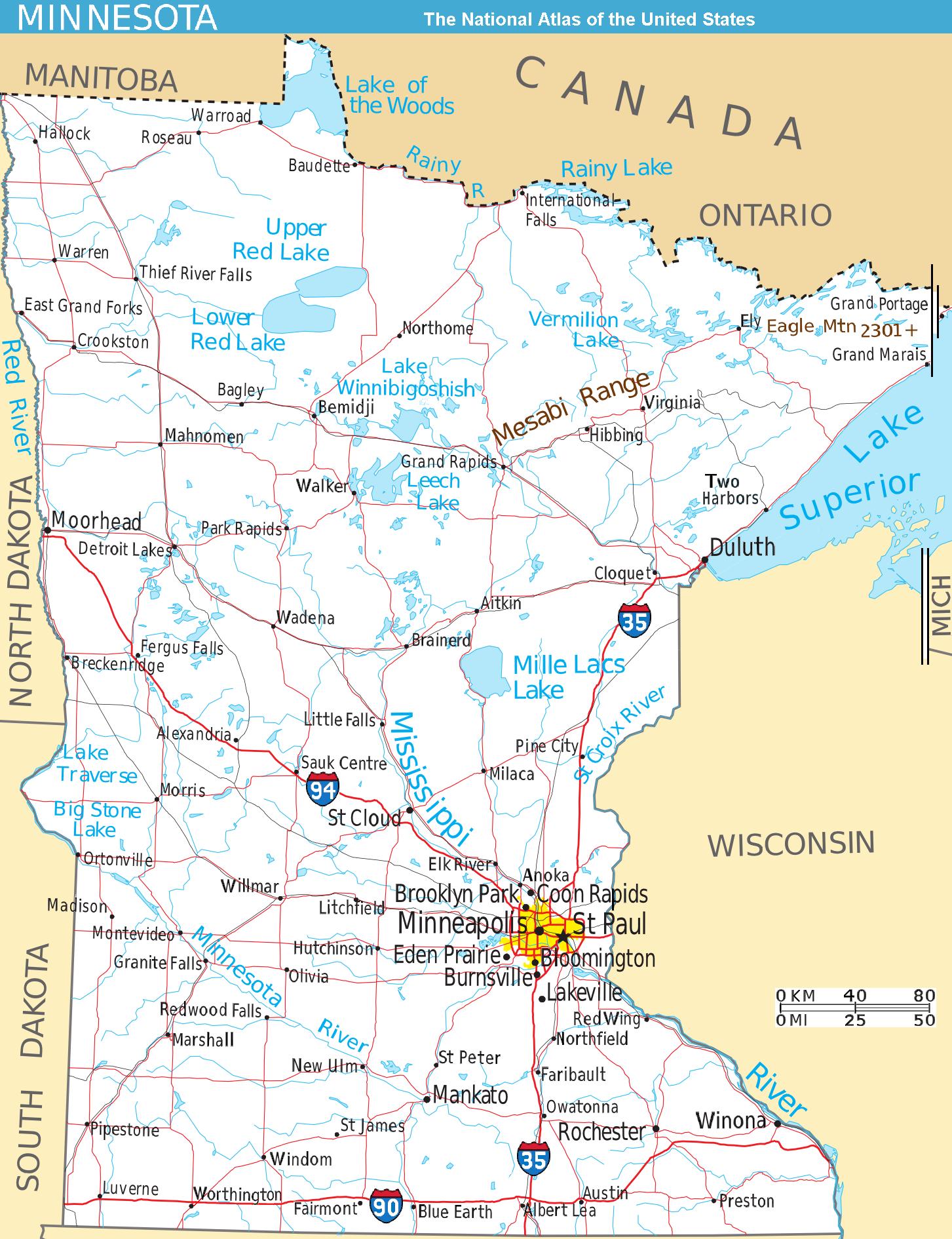
Scalable map of the U.S. state of Minnesota, showing terrain features: hills, lakes, rivers, roads and major towns, in quick photographic format (JPEG) to highlight terrain features. The Mesabi Range, Mount Eagle, and nearby states are labeled; the Interstate icons are enlarged 40%; and major cities are bolded 20%-40% for readability when scaled to 310px display width. The distance scale is shown in miles/kilometers, and labels appear 4x times larger than original in the US National Atlas, at similar display width. Format: Quick JPEG format for photographic quality, extracted/reduced from National-Atlas file of PNG format, 130x times more massive. Names have been enlarged for readability when map is resized smaller. Map is huge and could be reduced more: the original PNG file might crash browsers with many open windows. |
| Date | |
| Source | National Atlas (cropped to extract terrain only, no legend, with several names enlarged/added) |
| Author | User:Wikid77 (from National Atlas of the United States) |
| Other versions |
The map has some related variations:
|


Licensing[edit]
This map was obtained from an edition of the National Atlas of the United States. Like almost all works of the U.S. federal government, works from the National Atlas are in the public domain in the United States.
Online access: NationalAtlas.gov | 1970 print edition: Library of Congress, Perry-Castañeda Library
|
File history
Click on a date/time to view the file as it appeared at that time.
| Date/Time | Thumbnail | Dimensions | User | Comment | |
|---|---|---|---|---|---|
| current | 15:01, 15 August 2007 | | 1,453 × 1,890 (432 KB) | Wikid77 (talk | contribs) | narrowed map 7px @left; +Scale km/mi; aligned "Red River" & "Minnesota River"; bolded 25 towns %40; aligned "NORTH.. SOUTH DAKOTA"; wider "LACS" |
| 16:33, 13 August 2007 |  | 1,460 × 1,890 (428 KB) | Wikid77 (talk | contribs) | narrowed map +1%=9%; aligned 2 "Red Lake" | |
| 15:38, 13 August 2007 |  | 1,475 × 1,890 (429 KB) | Wikid77 (talk | contribs) | narrowed map 8% (125px) to magnify labels 8%; clarified "Vermilion Lake" | |
| 13:37, 13 August 2007 |  | 1,600 × 1,890 (433 KB) | Wikid77 (talk | contribs) | narrowed map 2% to magnify labels; enlarged Interstate icons & "Duluth" 40%; aligned "Red"/"Mille Lacs" and other rivers/lakes; enlarged town names 30%; shortened map 3% to magnify; cut "I-65" icon | |
| 00:16, 13 August 2007 |  | 1,630 × 1,975 (434 KB) | Wikid77 (talk | contribs) | aligned "Mesabi Range" also "Duluth"; clarified many town names | |
| 18:02, 12 August 2007 |  | 1,630 × 1,975 (433 KB) | Wikid77 (talk | contribs) | {{Information| | Description=Scalable map of the U.S. state of Minnesota, showing terrain features: hills, lakes, rivers, roads and major towns, in quick photographic format (JPEG) to highlight terrain features. The [[:en:Mesabi Mountain |
You cannot overwrite this file.
File usage on Commons
There are no pages that use this file.
File usage on other wikis
The following other wikis use this file:
- Usage on de.wikipedia.org
- Usage on en.wikipedia.org
- Usage on es.wikipedia.org
- Usage on fr.wikipedia.org
- Usage on he.wikivoyage.org
- Usage on ja.wikipedia.org
- Usage on lt.wikipedia.org
- Usage on sv.wikipedia.org