File:Middle east graphic 2003.jpg

Tập tin gốc (2.973×2.685 điểm ảnh, kích thước tập tin: 3,91 MB, kiểu MIME: image/jpeg)
Chú thích
Chú thích
 | This image was uploaded in the JPEG format even though it consists of non-photographic data. This information could be stored more efficiently or accurately in the PNG or SVG format. If possible, please upload a PNG or SVG version of this image without compression artifacts, derived from a non-JPEG source (or with existing artifacts removed). After doing so, please tag the JPEG version with {{Superseded|NewImage.ext}} and remove this tag. This tag should not be applied to photographs or scans. If this image is a diagram or other image suitable for vectorisation, please tag this image with {{Convert to SVG}} instead of {{BadJPEG}}. If not suitable for vectorisation, use {{Convert to PNG}}. For more information, see {{BadJPEG}}. |
Miêu tả[sửa]
Courtesy of the University of Texas Libraries, The University of Texas at Austin http://www.lib.utexas.edu/maps/middle_east.html
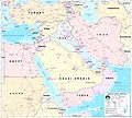
High-resolution political / railway / roadmap of the Middle East from 2003.
Further background at http://erg.usgs.gov/nimamaps/.
The map contains several major errors, for example, Haifa, Israel is located where Acre should be, and Tel Aviv is approximately where Netanya should be.
Giấy phép[sửa]
| Public domainPublic domainfalsefalse |
This image is a work of the United States National Geospatial-Intelligence Agency or one of its predecessor agencies. As a work of the U.S. federal government, the image is in the public domain.
English ∙ српски / srpski ∙ 日本語 ∙ +/− |
 |
Lịch sử tập tin
Nhấn vào ngày/giờ để xem nội dung tập tin tại thời điểm đó.
| Ngày/Giờ | Hình xem trước | Kích cỡ | Thành viên | Miêu tả | |
|---|---|---|---|---|---|
| hiện tại | 22:30, ngày 8 tháng 2 năm 2012 |  | 2.973×2.685 (3,91 MB) | M0tty (thảo luận | đóng góp) | Remove compression artefacts by a bilateral filtering. |
| 21:43, ngày 14 tháng 7 năm 2006 |  | 2.973×2.685 (1.013 kB) | Unquietwiki (thảo luận | đóng góp) | ''Courtesy of the University of Texas Libraries, The University of Texas at Austin'' [http://www.lib.utexas.edu/maps/middle_east.html http://www.lib.utexas.edu/maps/middle_east.html] High-resolution political / railway / roadmap of the Middle East. |
Bạn không được phép ghi đè tập tin này.
Trang sử dụng tập tin
5 trang sau sử dụng tập tin này:
Sử dụng tập tin toàn cục
Những wiki sau đang sử dụng tập tin này:
- Trang sử dụng tại ar.wikipedia.org
- ويكيبيديا:قوالب/بذور
- ويكيبيديا:قوالب/بذور/جدول بذرة 1
- قالب:بذرة جغرافيا الشرق الأوسط
- بادية الشام
- محافظة العاصمة (البحرين)
- خليج عدن
- دزفول
- زاغروس
- مسجد سليمان
- زاينده
- مسرح أحداث الشرق الأوسط خلال الحرب العالمية الثانية
- الحويزة (مدينة)
- قائمة جزر الخليج العربي
- شرق المتوسط
- قائمة نزاعات الشرق الأوسط الحديثة
- مستخدم:Adnanzoom/مساعدات
- عبد الله بن سعيد
- قرار مجلس الأمن التابع للأمم المتحدة رقم 1381
- مستخدم:ASammour/بذرة-بوابة
- شرف الدين بن الحسن
- فخر الدين بن عدي
- صخر بن صخر بن مسافر
- قالب:بذرة أعلام الشرق الأوسط
- أبجر التاسع
- Trang sử dụng tại arz.wikipedia.org
- Trang sử dụng tại ba.wikipedia.org
- Trang sử dụng tại be.wikipedia.org
- Trang sử dụng tại bn.wikipedia.org
- Trang sử dụng tại ca.wikipedia.org
- Trang sử dụng tại ce.wikipedia.org
- Trang sử dụng tại ckb.wikipedia.org
- Trang sử dụng tại el.wikipedia.org
- Trang sử dụng tại en.wikipedia.org
Xem thêm các trang toàn cục sử dụng tập tin này.
Đặc tính hình
Tập tin này chứa thông tin bổ sung, có thể được thêm từ máy ảnh kỹ thuật số hoặc máy quét được sử dụng để tạo hoặc số hóa tệp.
Nếu tập tin đã được sửa đổi so với trạng thái ban đầu, một số chi tiết có thể không phản ánh đầy đủ tập tin đã sửa đổi.
| Hướng | Thường |
|---|---|
| Phân giải theo chiều ngang | 300 điểm/inch |
| Phân giải theo chiều cao | 300 điểm/inch |
| Phần mềm sử dụng | GIMP 2.7.3 |
| Ngày giờ sửa tập tin | 23:27, ngày 8 tháng 2 năm 2012 |
| Phiên bản Exif | 2.1 |
| Phiên bản Flashpix được hỗ trợ | 1 |
| Không gian màu | Chưa hiệu chỉnh |
| Chiều ngang hình | 2.973 điểm ảnh |
| Chiều cao hình | 2.685 điểm ảnh |
