File:Muni Metro with CS.svg

File originale (file in formato SVG, dimensioni nominali 1 600 × 1 380 pixel, dimensione del file: 64 KB)
Didascalie
Didascalie
Dettagli[modifica]
| Descrizione |
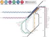
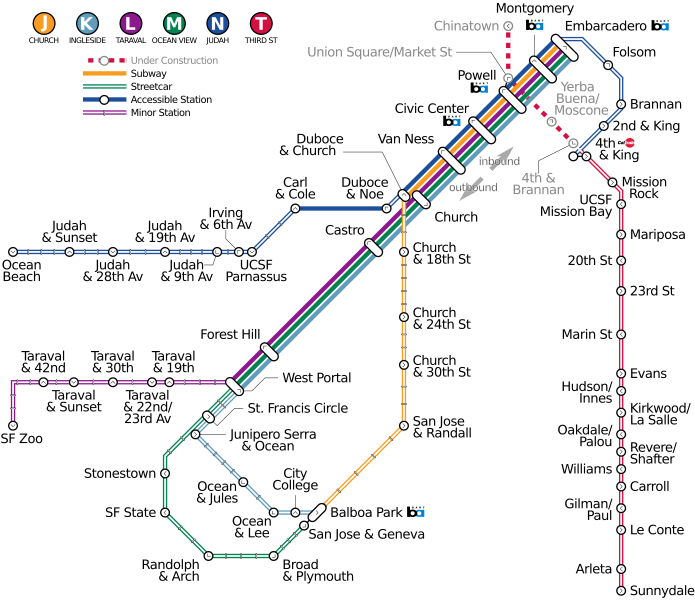
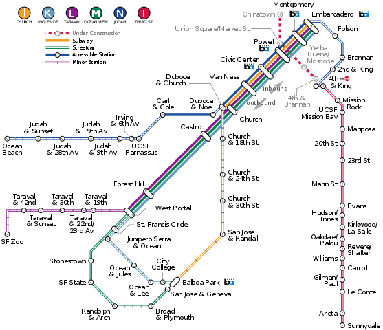
English: Map of Muni Metro subway/light rail/streetcar system in San Francisco, showing Central Subway tunnel (under construction as of 2016) and revised routing for T-Third. |
|||||
| Data | ||||||
| Fonte |
Opera propria, derived from sources listed below:
|
|||||
| Autore | Mliu92 | |||||
| Licenza (Riusare questo file) |
Caltrain and BART logos reused as public domain images:
|
|||||
| Altre versioni |
Questo file deriva da:
|


.svg)
.svg)
Licenza[modifica]
- Tu sei libero:
- di condividere – di copiare, distribuire e trasmettere quest'opera
- di modificare – di adattare l'opera
- Alle seguenti condizioni:
- attribuzione – Devi fornire i crediti appropriati, un collegamento alla licenza e indicare se sono state apportate modifiche. Puoi farlo in qualsiasi modo ragionevole, ma non in alcun modo che suggerisca che il licenziante approvi te o il tuo uso.
- condividi allo stesso modo – Se remixi, trasformi o sviluppi il materiale, devi distribuire i tuoi contributi in base alla stessa licenza o compatibile all'originale.
Cronologia del file
Fare clic su un gruppo data/ora per vedere il file come si presentava nel momento indicato.
| Data/Ora | Miniatura | Dimensioni | Utente | Commento | |
|---|---|---|---|---|---|
| attuale | 23:29, 27 mag 2018 | | 1 600 × 1 380 (64 KB) | Mliu92 (discussione | contributi) | Added Taraval/19th on L; relocated West Portal label with leader. |
| 14:35, 25 mag 2018 |  | 1 600 × 1 380 (64 KB) | Mliu92 (discussione | contributi) | Updates to L Taraval (removed minor closed stations, added T&30th, T&42nd; M Ocean View (removed minor station); N Judah (added Irving&6th, relocated inbound terminal 4+K to cross T Third). Detail improvements to leaders to accommodate changes. | |
| 04:24, 19 mag 2018 |  | 1 600 × 1 380 (63 KB) | Mliu92 (discussione | contributi) | Added leaders to selected stations. I didn't think that leaders were important before, but have had a change of heart because they make the spacing of labels better. | |
| 16:58, 22 mar 2016 |  | 1 600 × 1 380 (62 KB) | Mliu92 (discussione | contributi) | Rearranged labels, clarified 4th/King station (there are two separate MUNI platforms at 4+K, one for T Third and one for N Judah). | |
| 14:09, 22 mar 2016 |  | 1 600 × 1 380 (62 KB) | Mliu92 (discussione | contributi) | Redrawn using geographic coordinates for MUNI stops. Added Judah & 28th (accessible stop). Simplified routing to increments of 45-degrees (T Third is not perfectly N-S for much of its southern half). | |
| 16:07, 21 mar 2016 |  | 1 610 × 1 060 (60 KB) | Mliu92 (discussione | contributi) | Detail improvement to J Church routing | |
| 15:05, 21 mar 2016 |  | 1 610 × 1 060 (60 KB) | Mliu92 (discussione | contributi) | Rerouted N Judah inbound from Embarcadero to better match geographical route. Rerouted T Third/Central Subway to better match geography. Removed K Ingleside inbound from Embarcadero; since the present (2016) alignment has T Third trains becoming K Ingl... | |
| 13:53, 21 mar 2016 |  | 1 820 × 1 060 (60 KB) | Mliu92 (discussione | contributi) | Rerouted J Church as it shares Duboce & Church station with N Judah. Noted surface portion of N Judah along Duboce. Detail improvements to outbound routing of M Ocean View and K Ingleside. Consolidated legend with line chart. | |
| 23:40, 20 mar 2016 |  | 1 820 × 1 060 (60 KB) | Mliu92 (discussione | contributi) | Revised placement of Chinatown station + noted T-Third from 4th/King to 4th/Brannan (under construction) is streetcar (surface) service. | |
| 17:14, 20 mar 2016 |  | 1 820 × 1 060 (60 KB) | Mliu92 (discussione | contributi) | User created page with UploadWizard |
Impossibile sovrascrivere questo file.
Utilizzo del file
Le seguenti 17 pagine usano questo file:
- User:Chumwa/OgreBot/Potential transport maps/2016 March 21-31
- User:Chumwa/OgreBot/Potential transport maps/2018 May 11-20
- User:Chumwa/OgreBot/Potential transport maps/2018 May 21-31
- User:Chumwa/OgreBot/Public transport information/2016 March 21-31
- User:Chumwa/OgreBot/Public transport information/2018 May 11-20
- User:Chumwa/OgreBot/Public transport information/2018 May 21-31
- User:Chumwa/OgreBot/Transport Maps/2016 March 21-31
- User:Chumwa/OgreBot/Transport Maps/2018 May 11-20
- User:Chumwa/OgreBot/Transport Maps/2018 May 21-31
- User:Chumwa/OgreBot/Travel and communication maps/2016 March 21-31
- User:Chumwa/OgreBot/Travel and communication maps/2018 May 11-20
- User:Chumwa/OgreBot/Travel and communication maps/2018 May 21-31
- User:Magog the Ogre/PD ineligible/2016 March 20-23
- User:Magog the Ogre/PD ineligible/2018 May 16-19
- User:Magog the Ogre/PD ineligible/2018 May 24-27
- File:Muni Metro.png
- File:Muni Metro (vector).svg
Utilizzo globale del file
Anche i seguenti wiki usano questo file:
- Usato nelle seguenti pagine di en.wikivoyage.org:
- Usato nelle seguenti pagine di fa.wikipedia.org:
- Usato nelle seguenti pagine di it.wikipedia.org: