File:Ph CALABARZON.png
Jump to navigation
Jump to search
No higher resolution available.
Ph_CALABARZON.png (465 × 449 pixels, file size: 42 KB, MIME type: image/png)
Captions
Captions
Add a one-line explanation of what this file represents
Summary[edit]
| Description |
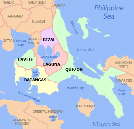
English: Political map of the CALABARZON Region, Philippines. Showing Batangas, Cavite, Laguna, Quezon and Rizal. Used the map template :Image:BlankMap-Philippines.png by User:TheCoffee. |
||||||||
| Date | 3 May 2007 (original upload date) | ||||||||
| Source | Transferred from en.wikipedia to Commons. | ||||||||
| Author | Scorpion prinz at English Wikipedia | ||||||||
| Permission (Reusing this file) |
Scorpion prinz at English Wikipedia, the copyright holder of this work, hereby publishes it under the following licenses:
This file is licensed under the Creative Commons Attribution 2.5 Generic license. Attribution: Scorpion prinz at English Wikipedia
You may select the license of your choice. |


|
File:Map of Calabarzon (local government units).svg is a vector version of this file. It should be used in place of this PNG file when not inferior.
File:Ph CALABARZON.png → File:Map of Calabarzon (local government units).svg
For more information, see Help:SVG. |
.svg) |
Original upload log[edit]
The original description page was here. All following user names refer to en.wikipedia.
- 2007-05-03 06:38 Scorpion prinz 465×449× (42619 bytes) new image
File history
Click on a date/time to view the file as it appeared at that time.
| Date/Time | Thumbnail | Dimensions | User | Comment | |
|---|---|---|---|---|---|
| current | 19:12, 28 November 2021 | | 465 × 449 (42 KB) | Magog the Ogre (talk | contribs) | Reverted to version as of 04:47, 26 November 2021 (UTC) |
| 03:42, 28 November 2021 | No thumbnail | 2,000 × 1,900 (397 KB) | Sanchezph (talk | contribs) | Reverted to version as of 03:43, 26 November 2021 (UTC) | |
| 04:47, 26 November 2021 |  | 465 × 449 (42 KB) | Hariboneagle927 (talk | contribs) | Reverted to version as of 08:54, 30 March 2021 (UTC) | |
| 03:43, 26 November 2021 | No thumbnail | 2,000 × 1,900 (397 KB) | Nissan2020 (talk | contribs) | Reverted to version as of 11:13, 28 March 2021 (UTC) | |
| 08:54, 30 March 2021 |  | 465 × 449 (42 KB) | HueMan1 (talk | contribs) | Reverted to version as of 07:59, 14 May 2020 (UTC) | |
| 11:13, 28 March 2021 | No thumbnail | 2,000 × 1,900 (397 KB) | Teamayuiyui (talk | contribs) | Update from 2021 | |
| 07:59, 14 May 2020 |  | 465 × 449 (42 KB) | HueMan1 (talk | contribs) | Reverted to version as of 00:19, 17 November 2009 (UTC) | |
| 21:42, 11 May 2020 | No thumbnail | 465 × 449 (99 KB) | Yuiyui2014 (talk | contribs) | 5 Provinces | |
| 00:19, 17 November 2009 |  | 465 × 449 (42 KB) | Robert Weemeyer (talk | contribs) | {{Information |Description={{en|Political map of the CALABARZON Region, en:Philippines. Showing en:Batangas, en:Cavite, Laguna, en:Quezon and en:Rizal. Used the map template [[:en: |
You cannot overwrite this file.
File usage on Commons
The following 4 pages use this file:
.svg)
File usage on other wikis
The following other wikis use this file:
- Usage on bcl.wikipedia.org
- Usage on cbk-zam.wikipedia.org
- Usage on ceb.wikipedia.org
- Usage on en.wikipedia.org
- Usage on es.wikipedia.org
- Usage on fr.wikipedia.org
- Usage on fy.wikipedia.org
- Usage on hi.wikipedia.org
- Usage on id.wikipedia.org
- Usage on ka.wikipedia.org
- ლაგუნის პროვინცია
- ლუსენა (ფილიპინები)
- კალაბარსონი
- ბატანგასი
- თარგი:კალაბარსონი
- კესონის პროვინცია
- დასმარინიასი
- კალამბა (ლაგუნა)
- როდრიგესი (რისალი)
- რისალი
- ტაგაიტაი
- ბატანგასის პროვინცია
- კავიტე
- ალფონსო (კავიტე)
- ამადეო (კავიტე)
- კარმონა (კავიტე)
- ხენერალ-ემილიო-აგინალდო (კავიტე)
- ხენერალ-მარიანო-ალვარესი (კავიტე)
- კავიტი (კავიტე)
- მაგალიანესი (კავიტე)
- მარაგონდონი
- მენდესი (კავიტე)
- ნაიკი (კავიტე)
- ნოველეტა
- როსარიო (კავიტე)
- სილანგი (კავიტე)
- ტანსა
- ტერნატე (კავიტე)
- ალამინოსი (ლაგუნა)
- ბაი (ლაგუნა)
- კალაუანი
- კავინტი
- ფამი
- კალაიაანი (ლაგუნა)
- ლილივი
- ლუისიანა (ლაგუნა)
- ლუმბანი
- მაბიტაკი
View more global usage of this file.