File:Plan de Paris 1422 1589 BNF07710749.png

File originale (2 016 × 1 676 pixel, dimensione del file: 5,25 MB, tipo MIME: image/png)
Didascalie
Didascalie
| Autore |
|
||||||||||||||||||||||||||||||||||||||||||
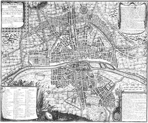
| Descrizione |
English: Plan of Paris in 1589, the sixth of eight chronological maps of Paris from Traité de la police
Français : Type : image fixe, monographie
Titre(s) : Sixième plan de la ville de Paris, et son accroissement, depuis le commencement du Regne de Charles VII l'an 1422, jusqu'a la fin du règne d'Henry III l'an 1589 [Image fixe numérisée] : Tiré des lettres patentes qui ont ordonné les ouvrages, des contrats passez avec les entrepeneurs, des registres de la chambre des Comptes, de l'Histoire et des Mémoires du temps Publication : Paris : [s.n.], 1705 Description matérielle : 1 carte ; 44,5 x 54,5 cm Collection : Collection d'Anville ; 00806 Note(s) : Cote : Ge DD 2987 (806) BNF Richelieu Cartes et Plans Reprod. Sc 87/658 . - Légende et description . - Présent dans le Traité de la police de Nicolas de Lamare, p. 78 Sujet(s) : Seine (Francecours d'eau), Paris (France), Paris (France) -- Quartiers anciens Notice BnF n° : FRBNF38638312 |
||||||||||||||||||||||||||||||||||||||||||
| Data | 1705 (représente Paris en 1589) | ||||||||||||||||||||||||||||||||||||||||||
| Fonte/Fotografo | Gallica | ||||||||||||||||||||||||||||||||||||||||||
| Altre versioni | Gallica 30/07/2013 | ||||||||||||||||||||||||||||||||||||||||||

| Previous public domain rationale, no longer applicable | ||
|---|---|---|
|
Cronologia del file
Fare clic su un gruppo data/ora per vedere il file come si presentava nel momento indicato.
| Data/Ora | Miniatura | Dimensioni | Utente | Commento | |
|---|---|---|---|---|---|
| attuale | 14:14, 2 ott 2005 | | 2 016 × 1 676 (5,25 MB) | David.Monniaux (discussione | contributi) | Auteur: Anville, Jean-Baptiste Bourguignon d' (1697-17) Type : image fixe, monographie Titre(s) : Sixième plan de la ville de Paris, et son accroissement, depuis le commencement du Regne de Charles VII l'an 1422, jusqu'a la fin du règne d'Henry III l |
Impossibile sovrascrivere questo file.
Utilizzo del file
Le seguenti 2 pagine usano questo file:
Utilizzo globale del file
Anche i seguenti wiki usano questo file:
- Usato nelle seguenti pagine di ar.wikipedia.org:
- Usato nelle seguenti pagine di de.wikipedia.org:
- Usato nelle seguenti pagine di en.wikipedia.org:
- Usato nelle seguenti pagine di fr.wikipedia.org:
- Usato nelle seguenti pagine di hu.wikipedia.org:
- Usato nelle seguenti pagine di ja.wikipedia.org:
- Usato nelle seguenti pagine di ko.wikipedia.org:
- Usato nelle seguenti pagine di nl.wikipedia.org:
- Usato nelle seguenti pagine di pl.wikipedia.org:
- Usato nelle seguenti pagine di pnb.wikipedia.org:
- Usato nelle seguenti pagine di ur.wikipedia.org: