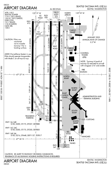
File:Seattle-Tacoma International Airport diagram(2).svg
Từ Wikimedia Commons, kho lưu trữ phương tiện nội dung mở
Bước tới điều hướng
Bước tới tìm kiếm

Kích thước bản xem trước PNG này của tập tin SVG: 379×576 điểm ảnh. Độ phân giải khác: 158×240 điểm ảnh | 316×480 điểm ảnh | 505×768 điểm ảnh | 674×1.024 điểm ảnh | 1.347×2.048 điểm ảnh.
Tập tin gốc (tập tin SVG, 379×576 điểm ảnh trên danh nghĩa, kích thước: 746 kB)
Thông tin tập tin
Dữ liệu có cấu trúc
Chú thích
Chú thích
Ghi một dòng giải thích những gì có trong tập tin này

|
This aeronautical chart image is possibly out of date, and thus is not to be used for navigational purposes. |
Miêu tả[sửa]
| Miêu tảSeattle-Tacoma International Airport diagram(2).svg |
English: FAA diagram for SEA |
| Nguồn gốc | http://www.avn.faa.gov/digital_tpp_search.asp |
| Tác giả | Federal Aviation Administration |
Giấy phép[sửa]
| Public domainPublic domainfalsefalse |
This image or file is a work of a Federal Aviation Administration employee, taken or made as part of that person's official duties. As a work of the U.S. federal government, the image is in the public domain in the United States.
English | italiano | македонски | മലയാളം | Nederlands | русский | sicilianu | українська | 中文 | +/− |
 |
Lịch sử tập tin
Nhấn vào ngày/giờ để xem nội dung tập tin tại thời điểm đó.
| Ngày/Giờ | Hình xem trước | Kích cỡ | Thành viên | Miêu tả | |
|---|---|---|---|---|---|
| hiện tại | 23:42, ngày 13 tháng 11 năm 2008 |  | 379×576 (746 kB) | Phongn (thảo luận | đóng góp) | {{Information |Description={{en|1=FAA diagram for SEA}} |Source=http://www.avn.faa.gov/digital_tpp_search.asp |Author=Federal Aviation Administration |Date= |Permission= |other_versions= }} <!--{{ImageUpload|full}}--> |
Bạn không được phép ghi đè tập tin này.
Trang sử dụng tập tin
Trang sau sử dụng tập tin này:
- File:00582AD.svg (tập tin đổi hướng)
Sử dụng tập tin toàn cục
Những wiki sau đang sử dụng tập tin này:
- Trang sử dụng tại af.wikipedia.org
- Trang sử dụng tại bn.wikipedia.org
- Trang sử dụng tại de.wikipedia.org
- Trang sử dụng tại en.wikipedia.org
- Trang sử dụng tại es.wikipedia.org
- Trang sử dụng tại et.wikipedia.org
- Trang sử dụng tại fa.wikipedia.org
- Trang sử dụng tại fr.wikipedia.org
- Trang sử dụng tại he.wikipedia.org
- Trang sử dụng tại id.wikipedia.org
- Trang sử dụng tại ja.wikipedia.org
- Trang sử dụng tại ru.wikipedia.org
- Trang sử dụng tại simple.wikipedia.org
- Trang sử dụng tại ta.wikipedia.org
- Trang sử dụng tại ur.wikipedia.org
- Trang sử dụng tại vi.wikipedia.org
- Trang sử dụng tại zh.wikipedia.org
Đặc tính hình
Tập tin này chứa thông tin bổ sung, có thể được thêm từ máy ảnh kỹ thuật số hoặc máy quét được sử dụng để tạo hoặc số hóa tệp.
Nếu tập tin đã được sửa đổi so với trạng thái ban đầu, một số chi tiết có thể không phản ánh đầy đủ tập tin đã sửa đổi.
| Chiều ngang | 378.948px |
|---|---|
| Chiều cao | 576px |
Dữ liệu có cấu trúc
Khoản mục được tả trong tập tin này
mô tả
Thể loại ẩn: