File:Sorbisches Siedlungsgebiet-hsb.png
Jump to navigation
Jump to search
Size of this preview: 430 × 599 pixels. Other resolutions: 172 × 240 pixels | 344 × 480 pixels | 551 × 768 pixels | 734 × 1,024 pixels | 1,398 × 1,949 pixels.
Original file (1,398 × 1,949 pixels, file size: 372 KB, MIME type: image/png)
Captions
Captions
Add a one-line explanation of what this file represents
Summary[edit]
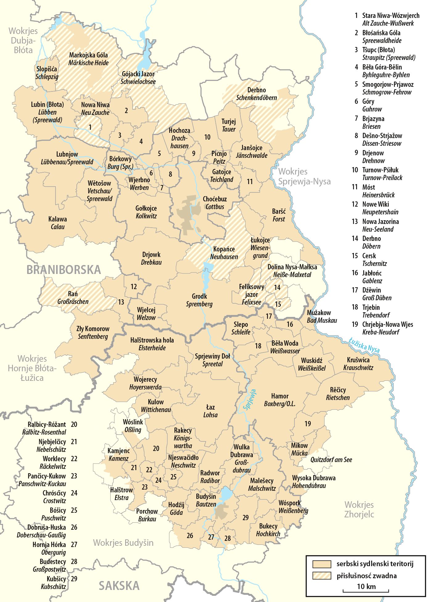
| Description |
Deutsch: Karte des sorbischen Siedlungsgebiets, obersorbische Version
English: Map of the Sorbian area, Upper Sorbian version
Hornjoserbsce: Karta Serbskeho sydlenskeho ruma, hornjoserbska wersija |
|
| Date | ||
| Source | Own work | |
| Author | NordNordWest | |
| Permission (Reusing this file) |
This file is licensed under the Creative Commons Attribution-Share Alike 3.0 Germany license.
 This file is licensed under the Creative Commons Attribution-Share Alike 3.0 Germany license.
|
|
| Other versions |
|


|
This map has been made or improved in the German Kartenwerkstatt (Map Lab). You can propose maps to improve as well.
|
File history
Click on a date/time to view the file as it appeared at that time.
| Date/Time | Thumbnail | Dimensions | User | Comment | |
|---|---|---|---|---|---|
| current | 10:28, 29 March 2018 | | 1,398 × 1,949 (372 KB) | NordNordWest (talk | contribs) | upd |
| 19:39, 12 July 2017 |  | 1,398 × 1,949 (580 KB) | NordNordWest (talk | contribs) | update | |
| 13:13, 7 January 2017 |  | 1,139 × 1,590 (777 KB) | NordNordWest (talk | contribs) | upd | |
| 12:41, 21 April 2016 |  | 1,139 × 1,455 (803 KB) | NordNordWest (talk | contribs) | upd | |
| 09:50, 21 January 2016 |  | 1,139 × 1,455 (703 KB) | NordNordWest (talk | contribs) | upd | |
| 19:47, 12 August 2010 |  | 1,139 × 1,455 (244 KB) | NordNordWest (talk | contribs) | c | |
| 19:38, 12 August 2010 |  | 1,139 × 1,455 (244 KB) | NordNordWest (talk | contribs) | c | |
| 18:36, 12 August 2010 |  | 1,139 × 1,455 (244 KB) | NordNordWest (talk | contribs) | == {{int:filedesc}} == {{Information |Description= {{de|Karte des sorbischen Siedlungsgebiets, obersorbische Version}} {{en|Map of the Sorbian area, Upper Sorbian version}} |Source={{Own}} |Date=2010-08-12 |
You cannot overwrite this file.
File usage on Commons
The following 7 pages use this file:
- User:J budissin/Uploads/BiH/2016 April 21-30
- User:J budissin/Uploads/BiH/2016 January 21-31
- User:J budissin/Uploads/BiH/2017 January 1-10
- User:J budissin/Uploads/BiH/2017 July 11-20
- User:J budissin/Uploads/BiH/2018 March 21-31
- File:Sorbisches Siedlungsgebiet-dsb.png
- File:Sorbisches Siedlungsgebiet.png
File usage on other wikis
The following other wikis use this file:
- Usage on be.wikipedia.org
- Usage on cs.wikipedia.org
- Usage on de.wikipedia.org
- Usage on el.wikipedia.org
- Usage on hsb.wikipedia.org
- Usage on lt.wikipedia.org
- Usage on ru.wikipedia.org
- Usage on sk.wikipedia.org
- Usage on sr.wikipedia.org
- Usage on uk.wikipedia.org