File:System of gdr border fortification.jpg
Bước tới điều hướng
Bước tới tìm kiếm

Kích thước hình xem trước: 800×588 điểm ảnh. Độ phân giải khác: 320×235 điểm ảnh | 640×470 điểm ảnh | 1.024×752 điểm ảnh | 1.280×940 điểm ảnh | 2.560×1.881 điểm ảnh | 2.853×2.096 điểm ảnh.
Tập tin gốc (2.853×2.096 điểm ảnh, kích thước tập tin: 2 MB, kiểu MIME: image/jpeg)
Chú thích
Chú thích
Ghi một dòng giải thích những gì có trong tập tin này
Miêu tả
[sửa]
| Miêu tả |
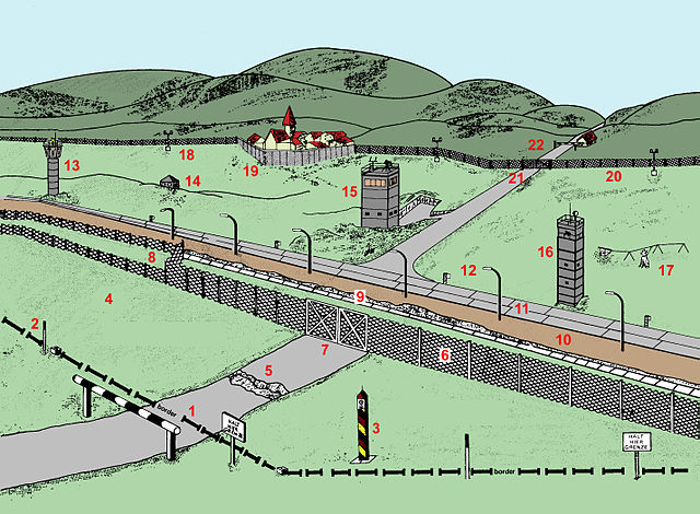
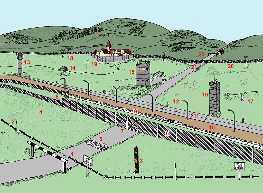
English: Diagram of the inner German border fortification system circa 1984.
The border (1) shown in the diagram cuts across a road which formerly linked east and west. Proceeding from west to east, the zonal border is marked on the western side by signposts (2) saying "HALT HIER GRENZE" ("STOP HERE BORDER"). Just behind the border, there is a border marker pole (3) with diagonal black, red and yellow stripes. The border is otherwise unmarked until the fortifications begin well into East German territory, leaving a strip of unfortified borderland (4). A short distance after the zonal border, i.e. on the Eastern side, the road is dug up (5), so there is an anti-vehicle ditch across its whole width. Then follows a metal-mesh fence (6), with a double gate (7) where the road is. To the left of the road, the metal-mesh fence forks to form a double fence (8); the area between the two fences is mined. Near the road, instead of a second metal-mesh fence, there is a concrete-faced anti-vehicle ditch (9). Next follows a flood-lit control strip (10); behind that, a guard patrol road running parallel to the border (11). After that comes a strip of open green territory containing various types of guard towers (13, 15, 16), a dog run (17) and an observation bunker (14); this is delimited by a signal fence which has floodlights spaced at regular intervals (18). The signal fence curves around a village (19) that is close to the border, excluding it from the border strip. Where it crosses the road, the signal fence has a gate (21), and further up the road, i.e. deeper in East German territory, the road is blocked by a horizontal barrier, beside which there is a little house (22).
Aragonés: Diagrama d'o sistema de fortificación d'a muga interalemana arredol de 1984. A muga (1) amostrada en o diagrama talla una carretera que d'antis mas uniba este y ueste. Arribando dende l'ueste enta l'este, a muga ye marcada por a parti occidental por sinyals (2) que dicen "HALT HIER GRENZE" ("STOP MUGA AQUÍ"). Chusto dezaga d'a muga, bi ha un sinyal de muga (3) con franchas diagonals negras, royas y amariellas. Antiparti d'isto, a muga no ye marcada dica as fortificacions que se troban ya en territorio de l'Alemanya Oriental, deixando una francha de territorio mugant sin fortificar (4). Una curta distancia dimpués d'a zona de muga, ye decir en o canto oriental, a carretera ye tallada (5) por una canal anti-vehiclos que la cruza perpendicularment. Dimpués bi ha una cleta metalica (6), con doble puerta (7) a on bi ha carretera. A la ezquierda d'a carretera, a cleta metalica se bifurca ta formar una doble cleta (8); l'aria entre as dos cletas ye minada. Chunto a la carretera, en cuentas d'una segunda cleta de metal, bi ha una fuesa anti-vehiclos de formigón (9). A continación una francha de control iluminada por focos (10) y dezaga d'ista, una carretera paralela a la muga ta os guardias de control (11). Dimpués viene una francha de territorio verde ubierto con diferents menas de torres de control (13, 15, 16), recorrida por cans guardians de forma regular (17) y un bunker d'observación (14); que ye amugau por una cleta con focos instalaus a intervalos regulars (18). Ista zaguera cleta fa una curva arredol d'un lugar (19) que ye amán d'a muga, excluyindo-lo d'a francha d'a muga. Quan trescruza a carretera, a cleta tien una puerta (21) ta permitir o paso d'ista enta o territorio d'Alemanya Oriental, a on a carretera ye bloqueyada por una barrera horizontal, chunto a la que se troba una chicota casa (22). |
| Ngày | vào khoảng 1984 |
| Nguồn gốc |
Stacy, William E. US Army Border Operations in Germany. US Army Military History Office. |
| Tác giả | Adapted by Vanished user 03 at en.wikipedia |
Giấy phép
[sửa]
Hình ảnh này là tác phẩm của binh sĩ hoặc nhân viên của Lục quân Hoa Kỳ, được chụp hoặc tạo ra khi đang làm nhiệm vụ. Là một tác phẩm của chính quyền liên bang Hoa Kỳ, hình ảnh hoặc tập tin này thuộc về phạm vi công cộng.
|
 |
Nhật trình tải lên đầu tiên
[sửa]
Trang miêu tả gốc từng tồn tại ở đây. Tất cả các tên người dùng sau là tên người dùng tại en.wikipedia.
- 2009-08-01 17:44 Vanished user 03 2853×2096× (2095279 bytes) {{Information |Description = Diagram of the [[inner German border]] fortification system ''circa'' 1984. |Source = Stacy, William E. ''US Army Border Operations in Germany.'' US Army Military History Office. |Date =
Lịch sử tập tin
Nhấn vào ngày/giờ để xem nội dung tập tin tại thời điểm đó.
| Ngày/Giờ | Hình xem trước | Kích cỡ | Thành viên | Miêu tả | |
|---|---|---|---|---|---|
| hiện tại | 10:14, ngày 23 tháng 2 năm 2011 | | 2.853×2.096 (2 MB) | File Upload Bot (Magnus Manske) (thảo luận | đóng góp) | {{BotMoveToCommons|en.wikipedia|year={{subst:CURRENTYEAR}}|month={{subst:CURRENTMONTHNAME}}|day={{subst:CURRENTDAY}}}} {{Information |Description={{en|Diagram of the en:inner German border fortification system ''circa'' 1984.<br /><br /> The border |
Bạn không được phép ghi đè tập tin này.
Trang sử dụng tập tin
Trang sau sử dụng tập tin này:
Sử dụng tập tin toàn cục
Những wiki sau đang sử dụng tập tin này:
- Trang sử dụng tại ar.wikipedia.org
- Trang sử dụng tại bg.wikipedia.org
- Trang sử dụng tại ca.wikipedia.org
- Trang sử dụng tại el.wikipedia.org
- Trang sử dụng tại en.wikipedia.org
- Trang sử dụng tại es.wikipedia.org
- Trang sử dụng tại et.wikipedia.org
- Trang sử dụng tại fr.wikipedia.org
- Trang sử dụng tại he.wikipedia.org
- Trang sử dụng tại hu.wikipedia.org
- Trang sử dụng tại it.wikipedia.org
- Trang sử dụng tại ja.wikipedia.org
- Trang sử dụng tại ka.wikipedia.org
- Trang sử dụng tại ru.wikipedia.org
- Trang sử dụng tại ru.wikinews.org
- Trang sử dụng tại uk.wikipedia.org
- Trang sử dụng tại vi.wikipedia.org
- Trang sử dụng tại zh.wikipedia.org