File:Territorios de la Segunda República Española-variante.svg
Jump to navigation
Jump to search

Size of this PNG preview of this SVG file: 396 × 600 pixels. Other resolutions: 158 × 240 pixels | 317 × 480 pixels | 507 × 768 pixels | 676 × 1,024 pixels | 1,352 × 2,048 pixels | 4,950 × 7,500 pixels.
Original file (SVG file, nominally 4,950 × 7,500 pixels, file size: 1.73 MB)
Captions
Captions
Add a one-line explanation of what this file represents
Summary[edit]
| Description |
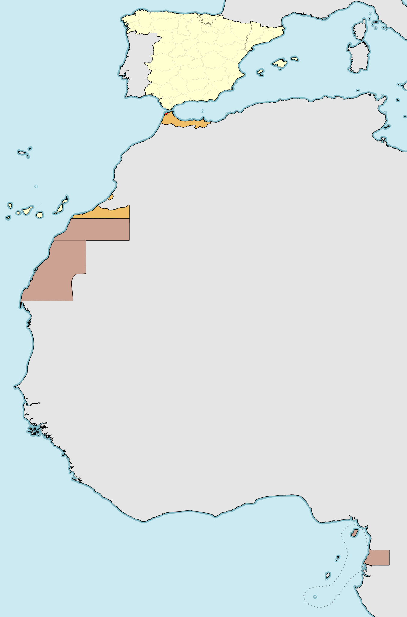
Deutsch: Die Zweite Spanische Republik mit Überseebesitzungen in Afrika:
Spanisches Kernland Protektorat Spanisch-Marokko Spanisch-Sahara und Spanisch-Guinea Internationale Zone von Tanger English: Map of the territories and colonies under the Second Spanish Republic government (1931-1936/39).
Spain, mainland and islands International Zone of Tangiers. Español: Mapa de los territorios bajo soberanía de la Segunda República Española (1931-1936/39).
España (territorio peninsular, Baleares, Canarias, Ceuta, Melilla y plazas de soberanía), con las regiones autónomas de Cataluña y País Vasco señalado y administración provincial (Diputaciones provinciales o forales) Protectorado español de Marruecos (norte de Marruecos, Ifni y Cabo Juby) Colonia de Sahara Español (Territorios de Saguia el-Hamra y Río de Oro), Colonia de Guinea Española (Territorios Españoles del Golfo de Guinea: Guinea continental o Río Muni, islas de Fernando Poo, Elobey, Annobón y Corisco (antigua Colonia de Elobey, Annobón y Corisco) Zona Internacional de Tánger |
| Date | (UTC) |
| Source |
This file was derived from: Territorios de la Segunda República Española.svg:  |
| Author |
|
| This is a retouched picture, which means that it has been digitally altered from its original version. Modifications: different color scheme. The original can be viewed here: Territorios de la Segunda República Española.svg:
|
Licensing[edit]
I, the copyright holder of this work, hereby publish it under the following licenses:
This file is licensed under the Creative Commons Attribution-Share Alike 3.0 Unported, 2.5 Generic, 2.0 Generic and 1.0 Generic license.
- You are free:
- to share – to copy, distribute and transmit the work
- to remix – to adapt the work
- Under the following conditions:
- attribution – You must give appropriate credit, provide a link to the license, and indicate if changes were made. You may do so in any reasonable manner, but not in any way that suggests the licensor endorses you or your use.
- share alike – If you remix, transform, or build upon the material, you must distribute your contributions under the same or compatible license as the original.

|
Permission is granted to copy, distribute and/or modify this document under the terms of the GNU Free Documentation License, Version 1.2 or any later version published by the Free Software Foundation; with no Invariant Sections, no Front-Cover Texts, and no Back-Cover Texts. A copy of the license is included in the section entitled GNU Free Documentation License. |
You may select the license of your choice.
Original upload log[edit]
This image is a derivative work of the following images:
- File:Territorios_de_la_Segunda_República_Española.svg licensed with Cc-by-sa-3.0,2.5,2.0,1.0, GFDL
- 2010-11-15T16:47:54Z Ras67 4950x7500 (1012236 Bytes) this is the right one
- 2010-11-15T16:44:39Z Ras67 2000x3030 (1012599 Bytes) repaired
- 2010-11-15T00:43:56Z Larry Yuma 4950x7500 (1793136 Bytes) -frameborder
- 2009-06-15T15:29:28Z HansenBCN 4950x7500 (1791372 Bytes) ajuste grosores
- 2009-06-15T15:20:21Z HansenBCN 4950x7500 (1789838 Bytes) coloración; añadidas las fronteras administrativas provinciales
- 2009-06-15T12:32:50Z HansenBCN 512x776 (915395 Bytes) correccion de bordes y transparencia
- 2009-06-15T12:30:37Z HansenBCN 512x776 (915328 Bytes) {{Information |Description={{en|1=Map of the territories under goverment of the Second Spanish Republic (1931-1936/39)}} {{es|1=Mapa de los territorios bajo soberanía de la Segunda República Española (1931-1936/39) Rojo:
Uploaded with derivativeFX
}}
File history
Click on a date/time to view the file as it appeared at that time.
| Date/Time | Thumbnail | Dimensions | User | Comment | |
|---|---|---|---|---|---|
| current | 12:22, 26 April 2013 | | 4,950 × 7,500 (1.73 MB) | Furfur (talk | contribs) | == {{int:filedesc}} == {{Information |Description={{de|1=Die Zweite Spanische Republik mit Überseebesitzungen in Afrika:{{legend|#FFFFCC|Spanisches Kernland}}{{legend|#EFBE67|Protektorat Spanisch-Marokko}}{{legend|#CCA293|Spanisch-Sahara und Spanisch-... |
You cannot overwrite this file.
File usage on Commons
The following page uses this file:
File usage on other wikis
The following other wikis use this file:
- Usage on azb.wikipedia.org
- Usage on de.wikipedia.org
- Usage on fr.wikipedia.org
- Usage on ht.wikipedia.org
- Usage on uk.wikipedia.org
Metadata
Categories:
- SVG maps of Spanish Morocco
- Locator maps of Spanish Morocco
- SVG maps of Spanish Sahara
- Locator maps of Spanish Sahara
- SVG locator maps of Spain
- Spain in the 1930s
- 1930s maps of Spain
- Africa in the 1930s
- Maps of Spanish Guinea
- Maps of 20th-century Spain
- Equatorial Guinea in the 20th century
- Maps of the Second Spanish Republic
- Language-neutral maps
- SVG maps of Western Sahara