File:Txu-oclc-6654394-nk-52-4th-ed.jpg
Bước tới điều hướng
Bước tới tìm kiếm

Kích thước hình xem trước: 490×599 điểm ảnh. Độ phân giải khác: 196×240 điểm ảnh | 392×480 điểm ảnh | 628×768 điểm ảnh | 837×1.024 điểm ảnh | 1.674×2.048 điểm ảnh | 4.087×5.000 điểm ảnh.
Tập tin gốc (4.087×5.000 điểm ảnh, kích thước tập tin: 6,55 MB, kiểu MIME: image/jpeg)
Chú thích
Chú thích
Ghi một dòng giải thích những gì có trong tập tin này
Miêu tả
[sửa]
| Miêu tả |
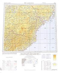
English: Map from the International Map of the World 1:1,000,000 (from map: "DELINEATION OF INTERNATIONAL BOUNDARIES MUST NOT BE CONSIDERED AUTHORITATIVE") |
| Ngày |
Compiled: 1967 Printed: October 1967 Scanned: 2007-04-03 06:33:57 |
| Nguồn gốc | Courtesy of the University of Texas Libraries, The University of Texas at Austin. ([1]) |
| Tác giả | Army Map Serivce (LU), Corps of Engineers, 1967 |
![[1]](http://legacy.lib.utexas.edu/maps/imw/txu-oclc-6654394-nk-52-4th-ed.jpg)
Giấy phép
[sửa]
This image or file is a work of a U.S. Army Corps of Engineers soldier or employee, taken or made as part of that person's official duties. As a work of the U.S. federal government, the image is in the public domain.
|
Lịch sử tập tin
Nhấn vào ngày/giờ để xem nội dung tập tin tại thời điểm đó.
| Ngày/Giờ | Hình xem trước | Kích cỡ | Thành viên | Miêu tả | |
|---|---|---|---|---|---|
| hiện tại | 06:07, ngày 7 tháng 12 năm 2019 | | 4.087×5.000 (6,55 MB) | Geographyinitiative (thảo luận | đóng góp) | User created page with UploadWizard |
Bạn không được phép ghi đè tập tin này.
Trang sử dụng tập tin
Không có trang nào sử dụng tập tin này.
Sử dụng tập tin toàn cục
Những wiki sau đang sử dụng tập tin này:
- Trang sử dụng tại ar.wikipedia.org
- Trang sử dụng tại en.wikipedia.org
- Trang sử dụng tại en.wiktionary.org
- Trang sử dụng tại es.wikipedia.org
- Trang sử dụng tại he.wikipedia.org
- Trang sử dụng tại it.wikipedia.org
- Trang sử dụng tại pa.wikipedia.org
- Trang sử dụng tại pnb.wikipedia.org
- Trang sử dụng tại th.wikipedia.org
- Trang sử dụng tại uz.wikipedia.org
- Trang sử dụng tại vi.wikipedia.org