File:USGS-PlanetMars-TopographicalMap.png
Bước tới điều hướng
Bước tới tìm kiếm

Kích thước hình xem trước: 800×367 điểm ảnh. Độ phân giải khác: 320×147 điểm ảnh | 640×294 điểm ảnh | 1.024×470 điểm ảnh | 1.280×587 điểm ảnh | 2.560×1.174 điểm ảnh | 10.292×4.720 điểm ảnh.
Tập tin gốc (10.292×4.720 điểm ảnh, kích thước tập tin: 6,72 MB, kiểu MIME: image/png)
Chú thích
Chú thích
Ghi một dòng giải thích những gì có trong tập tin này
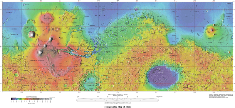
Topographical map of Mars, encompassing latitudes 57°N to 57°S, produced by the USGS
Miêu tả
[sửa]| Miêu tả |
English: USGS - Planet Mars - Topographical Map - 1-24-2005 - Geologic Investigations Series I-2782 These maps are based on data from the Mars Orbiter Laser Altimeter (MOLA; Smith and others, 2001), an instrument on NASA’s Mars Global Surveyor (MGS) spacecraft (Albee and others, 2001). The image used for the base of this map represents more than 600 million measurements gathered between 1999 and 2001, adjusted for consistency (Neumann and others, 2001, 2003) and converted to planetary radii. These have been converted to elevations above the areoid as determined from a martian gravity field solution GMM-2B (Lemoine and others, 2001), truncated to degree and order 50, and oriented according to current standards (see below). The average accuracy of each point is originally ~100 meters in horizontal position and ~1 meter in radius (Neumann and others, 2001). However, the total elevation uncertainty is at least ±3 m due to the global error in the areoid (±1.8 meters according to Lemoine and others [2001]) and regional uncertainties in its shape (G.A. Neumann, written commun., 2002). The measurements were converted into a digital elevation model (DEM; G.A. Neumann, written commun., 2002; Neumann and others, 2001; Smith and others 2001) using Generic Mapping Tools software (Wessel and Smith, 1998), with a resolution of 0.015625 degree per pixel or 64 pixels per degree. In projection, the pixels are 926.17 meters in size at the equator. Data are very sparse near the two poles (above 87° north and below 87° south latitude) because these areas were sampled by only a few off-nadir altimetry tracks. Gaps between tracks of 1–2 km are common, and some gaps of up to 12 km occur near the equator. DEM points located in these gaps in MOLA data were filled by interpolation. |
| Ngày | |
| Nguồn gốc | https://pubs.usgs.gov/imap/i2782/; https://pubs.usgs.gov/imap/i2782/i2782_sh1.pdf |
| Tác giả | U.S. Geological Survey |
| Phiên bản khác |
|


Giấy phép
[sửa]
Hình này thuộc phạm vi công cộng tại Hoa Kỳ vì toàn bộ nội dung của nó được lấy từ Cục Khảo sát Địa chất Hoa Kỳ (USGS), một cơ quan thuộc Bộ Nội vụ Hoa Kỳ. Xem chính sách chính thức về bản quyền của USGS để biết thêm thông tin.
|
| This file is in the public domain in the United States because it was solely created by NASA. NASA copyright policy states that "NASA material is not protected by copyright unless noted". (See Template:PD-USGov, NASA copyright policy page or JPL Image Use Policy.) | ||
 |
Warnings:
|
Lịch sử tập tin
Nhấn vào ngày/giờ để xem nội dung tập tin tại thời điểm đó.
| Ngày/Giờ | Hình xem trước | Kích cỡ | Thành viên | Miêu tả | |
|---|---|---|---|---|---|
| hiện tại | 18:11, ngày 4 tháng 10 năm 2021 | | 10.292×4.720 (6,72 MB) | Cherurbino (thảo luận | đóng góp) | same 256 clr, larger size + legend |
| 00:19, ngày 16 tháng 5 năm 2019 |  | 7.245×3.204 (11,38 MB) | Huntster (thảo luận | đóng góp) | Crop from original, manually trim out right side text, push title text up a bit. | |
| 02:14, ngày 15 tháng 5 năm 2019 |  | 3.472×1.544 (7,43 MB) | Drbogdan (thảo luận | đóng góp) | User created page with UploadWizard |
Bạn không được phép ghi đè tập tin này.
Trang sử dụng tập tin
3 trang sau sử dụng tập tin này:
Sử dụng tập tin toàn cục
Những wiki sau đang sử dụng tập tin này:
- Trang sử dụng tại el.wikipedia.org
- Trang sử dụng tại en.wikipedia.org
- Trang sử dụng tại hr.wikipedia.org
- Trang sử dụng tại ru.wikipedia.org
- Trang sử dụng tại vi.wikipedia.org