There is no time about this area, could match the Tibetan Empire (618–842) but a big part of what is described as Amdo was then in Tuyuhun, and after retaliation of its people by Tibetan Empire, integrated in Tang dynasty Empire.
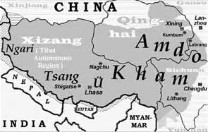
Tibet itself has been divided in 4 regions. Ü and Tsang around Lhassa, Ngari at the west and kham nearest at west. See a more accurate map, at least during Qing dynasty in 1820 .
@Antemister and Popolon: This map is not a historical map, and does not pretend to be one, the whole discussion above time is anachronistic as the map is still valid today. the map simply describes the traditional divisions of Tibet by ethnocultural and linguistic characteristics. It is still the way Tibetans define/distinguish themselves, and the terminology used both commonly and in academic circles.
@Antemister: This map is derivated from that other map by Professor Adreas Gruschke, a map appearing in several of his publications. There are more similar maps on commons, with description of their sources. The alleged 1820 Qing Dynasty map above does not appear to be based on historic maps, and seems to be own work of a Chinese Wikipedian.
Tibetischer Kulturraum Karte.pngTibetischer Kulturraum Karte 2.pngMap of Tibet Ü-Tsang Amdo and Kham.jpg
I will also remove the "disputed" tag as it has not been stated what is disputed in the factual accuracy of the file or its description. --Tiger Chair (talk) 16:06, 26 August 2017 (UTC)[reply]
That's clear, but is there any source that includes boundaries for these "cultural provinces". It is OK to just write it approximately into a map, but not trying to draw such colored, fading areas.--Antemister (talk) 16:31, 27 August 2017 (UTC)[reply]
Yes, there are sources, but these sources do emphasise on the fact that the boundaries cannot be precisely defined, have been changing with time, and can also slightly differ depending on which criteria is used (geographic, linguistic, etc.). Border areas between the different regions do also often feature mixed characteristics. For all these reasons it is impossible (and would be wrong) to attempt defining clear and intangible borders between Kham, Amdo and Ü-Tsang in a general article about these regions (some definitions would for exemple include Ngari into Ü-Tsang, others not), as well as for the sino-Tibetan border which has also been evolving along time. Nevertheless, the concepts of Kham, Amdo and Ü-Tsang remain very important from a linguistic, ethnographic, historic and geographic perspective, as they do provide a very useful approximate division of Tibet across many periods of history until today. These three maps (123) are therefore totally fine for use in Wikipedia articles, the last one with the fading colours would perfectly illustrate the kind of blending you may find in some borders areas. For more information, see "Introduction to Frontier Tibet: Trade and Boundaries of Authority in Kham" (link). You will also find an attempt at defining approximate boundaries in the book Tibetan Philip Denwood (page 27 Geographical Distribution). I hope this can help. Cheers, --Tiger Chair (talk) 17:19, 27 August 2017 (UTC)[reply]
The maps of the three Tibetan provinces, strangely enough correspond to the territorial claims of the Tibetan government in exile. Far from being maps designed by a geographer, a historian or a linguist, they are politically-motivated maps usually found in Tibetan nationalist literature.
How can any of the maps featured in this page be of historical value when the territories involved, their borders and their control have fluctuated so much over the centuries?
Also, these maps say nothing about the various languages and their variants spoken over such a huge expanse, let alone the ethnic groups living within the three provinces.
The above comment by Elnon is rather awkward. Maps used in the exiled community often look quite different (see for example this one from the Tibet Office), as they usually exclude Tibetan areas in other countries than China, they exclude Chinese claims in India, they often do not show current administrative divisions of China, and they do often include Xinning as well as additional Northern/Eastern Amdo areas and Southern Kham areas in their claims. To the opposite, the map "Tibetischer Kulturraum Karte 2.png" is showing and naming all Tibetan autonomous administrative entities as per current administration divisions of the People Republic of China (Tibet Autonomous Region, Tibetan Autonomous Prefectures, Tibetan Autonomous Counties), as well as Tibetan areas in other countries, so it does reflect the Chinese POV rather than the exiled Tibetan POV, which is in my opinion not a very big deal (from a neutrality POV) for such a general map as the differences between Chinese and Tibetan claims are rather small in terms of territorial extent, so we hardly notice it without having in-depth knowledge and without observing the map in details.
The third map a just a derivated work from Gruschke map, and also shows the PRC administrative divisions.
These maps are very useful in showing the different cultural and ethnolinguistical areas of Tibet. We find many more similar maps in scholar publications, such as in "Introduction to “Frontier Tibet: Trade and Boundaries of Authority in Kham”" published in the East Asian History and Culture Review, juin 2016 (see Map 1. Obviously these maps should be used properly with the appropriate description, but this is not an issue to discuss in Commons but in the different wikipedias. I haven't observed so far any misuse of those maps. Similarly, administrative maps would be totally useless in articles about Kham, Amdo, Ü, Tsang, Ü-Tsang, Changtang, as those areas span over different administrative divisions.
I am totally surprised by the comment "these maps should be used sparingly if not at all". What map should be used to show the location of Kham, Amdo and Ü-Tsang if not those maps?--Tiger Chair (talk) 18:13, 28 August 2017 (UTC)[reply]
When on December 7, 2006 a contributor under the pseudonym of Gruschke (purportedly Swiss Tibetologist Andreas Gruschke) uploaded to Commons the black & white map, claiming it to be his own work "(Karte: A Gruschke, Freiburg)", it was accompanied with the caption “Lage der osttibetischen Regionen Amdo und Kham" (Location of the eastern Tibetan regions Amdo and Kham) but no source was indicated, which made it seem like original work.
On August 27th, 2017, Tiger Chair uploaded the file "Tibet provinces.png" - a refurbished version of edited the "map of Tibet Ü-Tsang Amdo and Kham" - citing as its source "The Jonangpa in East Tibet, the foundations of the development, the decline and the survival of a long-forgotten Tibetan-Buddhist school". This certainly is an improvement over the previous version but one cannot help notice that no indication is available as to where and when this study was published. Why is that? --Elnon (talk) 14:37, 30 August 2017 (UTC)[reply]
As general information regarding the above comment by Elnon:
I have not cited "The Jonangpa in East Tibet, the foundations of the development, the decline and the survival of a long-forgotten Tibetan-Buddhist school" as the source for file (as Elnon is pretending), it seems Elnon found the English translation somewhere else on the web.
In short, I have really no clue what Elnon is talking about, his whole discourse sounds pretty incoherent. Concerning my edit on the description, I have simply replaced information that had been inserted by a bot with some more precise information by:
indicating that the file was uploaded by Gruschke himself (see his profile).
indicating in which article the map can be found ("found in... Jonangpa...")
To my knowledge, Gruschke's Jonangpa article has been published in different languages and versions (some with illustrations including this map, some without illustration), initially in "Tibetan Studies: Proceedings of the Ninth Seminar of the International Association for Tibetan Studies, Leiden 2000 (PIATS 2000, published in 2002)" (see here or here for full reference). I have not indicated the Jonangpa article as the primary source for this map, because it can be found in earlier publications by the same author, most notably in the four volumes of Cultural Monuments of Outer Tibet published between 2001 and 2005. As I don't have currently access to these books in order to confirm and give the exact reference with page number, I chose to only mention the name of another article by Gruschke that I had personally verified (see here) but a reference linking this map to the book "Cultural Monuments..." can be found here if someone is doubting about my affirmations. So I believe there is hardly a way to be more correct in the edits I made. Elnon has not provided any justification for his claims that these maps correspond to "politically-motivated maps usually found in Tibetan nationalist literature".
This is a very serious statement proffered by an anonymous contributor targeting the work of a China-based foreign university professor who has graciously donated to Wikimedia some of his otherwise copyrighted work. This kind of baseless forum-style insinuations do have no place in Commons, and could easily jeopardize the career of this scholar, knowing the very sensitive nature of the Tibetan issue in China and the very restrictive policies applying towards academic researchers.--Tiger Chair (talk) 19:35, 30 August 2017 (UTC)[reply]
An historical map, should be defined in time for fronter border, or shouldn't have name at all. With this kind of map, we have more chance to encounter errors and inaccurate things than historical facts. This is really unencyclopedic material. Since several years this kind of unaccurate maps are used by some people to push the idea of a possible unchanging country, and the idea of an unique culture. This kind of thing never existed anywhere on earth. Which country on earth has or had been only one united culture at anytime ??? The second map already show some mixed and unrelated cultures, like goloks, mongolians and hui regions in current Qinghai. As an example, Ladakh people, that following this map is Tibetan culture, has 46% of muslims, "Within Ladakh itself, people fo divers regions, religions and classes claim to represent the authentic Ladakh", the author add too, "even though no Ladkhi that I have ever met classifies himself or herself as Tibetan, poltically nor ideologically." [1], (removed from french article by Tiger Chair, has this doesn't follow it's own point of view). The author of this book continue his complain about lot of scholar that want to push Ladakhi as pure source of Tibetan culture despite of their fundamental mixing of parts of the tibetan culture among the local cultures. Some scholar, as Crook claims than Ladakhi is far from hinduist and muslim culture, despite, the fact that about half of the population practise islam, and their biased point of view about muslim population [2]. The author speaks about the European fantasme of an united Tibet, as described by Peter Bishop in The Myth of Shangrila, 1989.p.22 Tenzin Jenba, speaks also, has a Tibetan ethnicity, Amdo/Khampa dialect speaker, about how it's hard to him to understand Gyarong language and culture, a matriarchal culture [3] among a mostly patriarchal Tibet. Culture like Moso (or en:Mosuo), in Sichuan, are also matriarchal one, and has a distinctive religion and system of social life. Same people that want to assimilate lot of culture has a only one, say that they are Tibetan in culture and so one, even if their language is en:Lolo-Burmese (another branch of the en:Sino-Tibetan languages). The en:Kingdom of Derge most of so called Kham, in current Sichuan, was a en:Tusi system [4] probably since mongolian en:Yuan Dynasty. Another author wrote the non-sens point of view of the ""tibetanization of Henan's Mongols" [5]Popolon (talk) 00:16, 31 August 2017 (UTC)[reply]
@Tiger Chair: On August 27, 2017, you did add some information to the "Map of Tibet Ü-Tsang Amdo and Kham.jpg file": the title of an article by Andreas Gruschke in which the map was to be found. As the article's title was in German, I had it translated into English by Googletranslate for every English-speaking Wikipedian to understand what it was about. Surprisingly, the name of the journal in which the article was published was missing. Then, after I brought this to your attention, you provided the missing information (along with your motives for withholding it in the first place). This is all very well but the original map, as found in Die Jonangpa in Osttibet, has something that is missing from the uploaded map, its key, namely its title Ethnic Tibet (whatever that means) and various explanations : international [boundaries], provincial boundaries, areas with a considerable Tibetan population. In other words, a truncated map of Ethnic Tibet is being passed off to the readers of Wikipedia as a map of the traditional Tibetan provinces. In my opinion, the best thing that can happen to this truncated map is to be left alone. --Elnon (talk) 10:30, 1 September 2017 (UTC)[reply]
@Elnon: please read carefully this discussion thread, you will notice that most of the points you raise in your last intervention have already been answered.
First, I already highlighted several times that "Gruschke's map shows the current administrative divisions of the PRC at provincial level" and that this is also the case for the other two maps: "is showing and naming all Tibetan autonomous administrative entities as per current administration divisions of the People Republic of China", "also shows the PRC administrative divisions".
Secondly, I explained that the map was not originally published in the Jonangpa article, but in Gruschke earlier published "Cultural Monuments of Outer Tibet" (I even gave a link showing it).
Thirdly, after asserting that maps like Prof. Gruschke's one are "politically-motivated maps usually found in Tibetan nationalist literature", you are now accusing him to upload a "truncated map of Ethnic Tibet is being passed off to the readers of Wikipedia as a map of the traditional Tibetan provinces" for having uploaded the file Map of Tibet Ü-Tsang Amdo and Kham.jpg without additional description. Obviously it is not a truncated map with the aim to deceive the reader (the description sounds quite obvious), it is just a different version of the same map (none of 123 are absolutely identical). You are more than welcome to add a more detailed description to the map (indicating the overlay with present-day borders etc) if you wish, this would be more productive.
You again write that these maps should better "be left alone", but you have never provided an explanation on what is wrong with those maps and what better maps should be used instead to show the location of Kham, Amdo and Ü-Tsang. It seems you simply reject the idea of having any map showing these cultural, linguistic, historic, traditional, ethnographic (whatever term your prefer) regions.--Tiger Chair (talk) 12:37, 1 September 2017 (UTC)[reply]
Uff, what a long discussion here, but althougha lot of sources a are cited, there does not seem to be map that includes even rough boundaries of these region. Anyway, is one of you able to draw maps?--Antemister (talk) 21:34, 4 September 2017 (UTC)[reply]
I don't really see the need for drawing an additional map with approximate borders, this has already been made by User:Kmusser, and the result is the present map, which is pretty good. On the issue of drawing more precise borders, I had given in my first intervention a link to an article by Stéphane Gross, principal investigator for the CNRS (the French National Centre for Scientific Reasearch) Kham project, which explains the impossibility to draw exact border. A more synthetic summary of the mapping issue can be found here at the CNRS project website, see this extract: "Even though some geographers, like Gruschke in The Cultural Monuments of Tibet’s Outer Provinces (2004, map 5) or Ryavec in A Historical Atlas of Tibet (2015, map 4), have suggested approximate borders of Kham cultural area (see map below), the definition of its clear demarcation with other cultural area of Tibet and with China still remains an open question and no consensus exists.". As I wrote on the French wikipedia, I currently have no access to Gruschke books to check if there is a more precise map than the one he uploaded in Commons, and I have no access either to A Historical Atlas of Tibet by Ryavec. However, you can see from this map overlaying both Gruschke and Ryavec delimitation attempts that there are quite significant differences, e.g. a large area of Qinghai up to almost Golmud is considered as Kham by Ryavec, but this area is included under Amdo in Gruschke's book. For this reason I don't think that we can do better than the present map if we would draw another one. If you are looking for non-academic material, Swiss map publisher Gecko Maps has published different maps of Tibet and East Tibet that include a map of historic Tibet with the "historical provinces" of Tibet, with clear delimitation between Amdo, Kham and Ü-Tsang-Ngari, see for example here or on the publisher website here or here (scroll down to the section "Historic Tibet"). I hope this helps, --Tiger Chair (talk) 23:09, 4 September 2017 (UTC)[reply]


