Tratado de Tordesillas
Jump to navigation
Jump to search
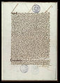
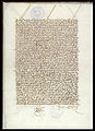
English: Original pages from the Treaty of Tordesillas.
Español: Páginas originales del Tratado de Tordesillas.
Français : Pages originales du Traité de Tordesillas.
Português: Página originais do Tratado de Tordesilhas.
-

-
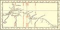 Early demarcation lines (1495-1545) for the Treaty of Tordesillas (1494).
 -
 Demarkationslinien nach Spanisch-Portugiesischen Vereinbarungen im 15. und 16. Jhd.
 -
 Español: Demarcaciones territoriales entre Portugal y el imperio español, resultando de la bula Papal Inter Caetera (1493) y de los tratados de Tordesillas (1494), y de Zaragoza (1529).
 -

-
 Tordesillas. Casa palacio del Tratado. Fotografía realizada el 20 abril de 2003 por el autor.User:Pelayo2
 -
 Monument to the treaty in Tordesillas
 -
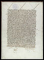
 1r
1r -
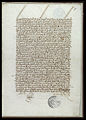
 1v
1v -
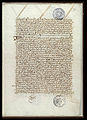
 2r
2r -
 2v
2v -
 3r
3r -
 3v
3v -
 4r
4r -
 4v
4v -
 5r
5r -
 5v
5v -
 6r
6r -
 6v
6v -
 7r
7r -
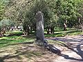 Uno de los mojones utilizados para delimitar.
 -
 An anachronous map of the Portuguese Empire (1415-1999). Red - actual possessions; Pink - explorations, areas of influence and trade and claims of sovereignty; Blue - main sea explorations, routes and areas of inluence.
 -
 Dark Green: Colonized area in its maximum extension ca 1650. Light green: Theoretical extension at the moment of its creation in 1542. Dark Brown: The Viceroyalty in 1816. Light Brown: De jure extension in 1816.


