File:Belgii novi, angliae novae, et partis Virginiae - novissima delineatio. NYPL433965.tiff
Jump to navigation
Jump to search

Size of this JPG preview of this TIF file: 700 × 600 pixels. Other resolutions: 280 × 240 pixels | 560 × 480 pixels | 897 × 768 pixels | 1,195 × 1,024 pixels | 2,391 × 2,048 pixels | 4,975 × 4,262 pixels.
Original file (4,975 × 4,262 pixels, file size: 60.67 MB, MIME type: image/tiff)
Captions
Captions
Add a one-line explanation of what this file represents
Summary[edit]
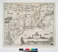
| Description | Belgii novi, angliae novae, et partis Virginiae : novissima delineatio. | |||||||||||||||||||||||||||||||||||||||||||||||||||||||||||||||||||||||||
| Notes | At foot of publisher statement: C.P. Note 2.) Described by Campbell as third state of map by Jan Jansson. Note 3.) Includes ill., decorative cartouches, and dedication to Gualthero de Raet. Note 4.) National Endowment for the Humanities Grant for Access to Early Maps of the Middle Atlantic Seaboard. Note 5.) Relief shown pictorially. | |||||||||||||||||||||||||||||||||||||||||||||||||||||||||||||||||||||||||
| Standard reference | Campbell, T. The Jansson-Visscher maps of New England, 3; NYPL. Dictionary catalog of the Map Division, VII, p. 140 | |||||||||||||||||||||||||||||||||||||||||||||||||||||||||||||||||||||||||
| Physical description | 1 map : hand col. ; 42 x 50 cm. | |||||||||||||||||||||||||||||||||||||||||||||||||||||||||||||||||||||||||
| Catalog Call Number | Map Div. 01-1865 [Filed with N.Y. Province 1690?] | |||||||||||||||||||||||||||||||||||||||||||||||||||||||||||||||||||||||||
| Date | 169-? | |||||||||||||||||||||||||||||||||||||||||||||||||||||||||||||||||||||||||
| Source |
|
|||||||||||||||||||||||||||||||||||||||||||||||||||||||||||||||||||||||||
| Author |
|
|||||||||||||||||||||||||||||||||||||||||||||||||||||||||||||||||||||||||
| Permission (Reusing this file) |
From The Lionel Pincus & Princess Firyal Map Division. Released on a CC0 license.[1] | |||||||||||||||||||||||||||||||||||||||||||||||||||||||||||||||||||||||||
| Other versions |
|
|||||||||||||||||||||||||||||||||||||||||||||||||||||||||||||||||||||||||
| Digital ID | 433965 | |||||||||||||||||||||||||||||||||||||||||||||||||||||||||||||||||||||||||
| Location | Stephen A. Schwarzman Building / The Lionel Pincus and Princess Firyal Map Division | |||||||||||||||||||||||||||||||||||||||||||||||||||||||||||||||||||||||||
| NYPL digital item published | 2-3-2004; updated 3-25-2011 | |||||||||||||||||||||||||||||||||||||||||||||||||||||||||||||||||||||||||


.jpg)

.jpg)


Licensing[edit]
| This file is made available under the Creative Commons CC0 1.0 Universal Public Domain Dedication. | |
| The person who associated a work with this deed has dedicated the work to the public domain by waiving all of their rights to the work worldwide under copyright law, including all related and neighboring rights, to the extent allowed by law. You can copy, modify, distribute and perform the work, even for commercial purposes, all without asking permission.
|
The making of this file was supported by Wikimedia UK.
To see other files made with the support of Wikimedia UK, please see the category Supported by Wikimedia UK.
|
File history
Click on a date/time to view the file as it appeared at that time.
| Date/Time | Thumbnail | Dimensions | User | Comment | |
|---|---|---|---|---|---|
| current | 01:06, 12 April 2014 |  | 4,975 × 4,262 (60.67 MB) | Fæ (talk | contribs) | =={{int:filedesc}}== {{NYPL_map |digital_id = 433965 |standard_reference = Campbell, T. The Jansson-Visscher maps of New England, 3; NYPL. Dictionary catalog of the Map Division, VII, p. 140 |record_id = 252818 |catalog_call_number = Map Div. 01-1865 [... |
You cannot overwrite this file.
File usage on Commons
The following 17 pages use this file:
- File:AMH-8632-NA Map of Nieuw Nederland featuring an inset showing Nieuw Amsterdam.jpg
- File:Atlas Maior - Novi Belgii - four colors.jpg
- File:Belgii Novi, Angliae Novae, et partis Virginiae (NYPL Hades-118550-54677).tif
- File:Dirk Jansz van Santen - map finish comparison.jpg
- File:Jansson-Visscher map.jpg
- File:Map-Novi Belgii Novæque Angliæ (Amsterdam, 1685).jpg
- File:NoviBelgii.jpg
- File:Novi Belgii Novaeque Angliae - nec non partis Virginiae tabula multis in locis emendata.jpg
- File:Novi Belgii Novaeque Angliae - nec non partis Virginiae tabula multis in locis emendata LOC 97683561.jpg
- File:Novi Belgii Novaeque Angliae - nec non partis Virginiae tabula multis in locis emendata LOC 97683561.tif
- File:Novi Belgii Novaeque Angliae nec non Pennsylvaniae et partis Virginiae tabula - CBT 6625605.jpg
- File:Novi Belgii Novaeque Angliae nec non Pennsylvaniae et partis Virginiae tabula multis in locis emendata (NYPL Hades-118204-53909).tif
- File:Novi Belgii Novaeque Angliae nec non partis Virginiae tabula (NYPL b14946244-434503).jpg
- File:Novi Belgii Novaeque Angliae nec non partis Virginiae tabula (NYPL b14946244-434503).tiff
- File:Novi Belgii Novaeque Angliae nec non partis Virginiae tabula multis in locis emendata (NYPL Hades-118553-54680).tif
- File:View of New Amsterdam from the harbor.jpg
- File:Visscher - Novi Belgii Novaeque Angliae (Detail Nieuw Amsterdam).png
.png)
Metadata
Categories:
- Maps by Jan Janssonius
- Maps by Pieter Schenk (I)
- Maps by Gerard Valck
- Map images supported by Wikimedia UK
- Adriaen van der Donck
- Maps made in the 17th century
- 1685 maps
- Maps of New England
- Old maps of New York (state)
- Maps of the Hudson River
- Old maps of New France
- Maps of Nieuw Nederland
- New Amsterdam
- Novi Belgii, Atlas Maior
- Maps by Nicolaes Visscher I
- Nicolaes Visscher II
- Dirk Janszoon van Santen
- Atlas Blaeu-Van der Hem
- Copper engravings
- Beavers in art