File:USSR Republics Numbered Alphabetically.png
Zur Navigation springen
Zur Suche springen
Größe dieser Vorschau: 800 × 547 Pixel. Weitere Auflösungen: 320 × 219 Pixel | 640 × 438 Pixel | 1.024 × 701 Pixel | 1.356 × 928 Pixel.
Originaldatei (1.356 × 928 Pixel, Dateigröße: 80 KB, MIME-Typ: image/png)
Bildtexte
Kurzbeschreibungen
Republics of the USSR: 1. Armenian USSR 2. Azerbaijani USSR 3. Belarusian USSR 4. Estonian USSR 5. Georgian USSR 6. Kazakhstan USSR 7. Kyrgyz USSR 8. Latvian 9. Lithuania 10. Moldova 11. Russian 12 Tajika 13. Turkmenistan 14. Ukraine 15. Uzbek

|
File:USSR Republics numbered by alphabet.svg ist eine vektorisierte Version dieses Bildes. Diese sollte an Stelle des Rasterbildes verwendet werden, sofern sie nicht schlechter ist.
File:USSR Republics Numbered Alphabetically.png → File:USSR Republics numbered by alphabet.svg
Für weitere Informationen siehe Help:SVG. |
 |
Beschreibung[Bearbeiten]
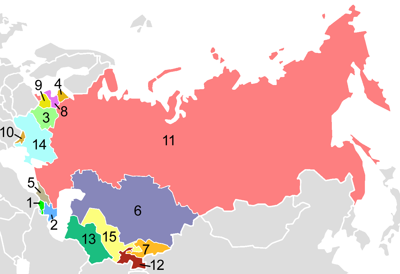
USSR Republics, numbered alphabetically.
Post-Soviet states in English alphabetical order:
| 1. | Armenia |
| 2. | Azerbaijan |
| 3. | Belarus |
| 4. | Estonia |
| 5. | Georgia |
| 6. | Kazakhstan |
| 7. | Kyrgyzstan |
| 8. | Latvia |
| 9. | Lithuania |
| 10. | Moldova |
| 11. | Russia |
| 12. | Tajikistan |
| 13. | Turkmenistan |
| 14. | Ukraine |
| 15. | Uzbekistan |
Map created by en:User:Aris_Katsaris, based on Image:Soviet Union Map.png in mimicry of the concept of fr:Image:USSR_Republics_Numbered_Alphabetically.png.
Lizenz[Bearbeiten]
| This map is ineligible for copyright and therefore in the public domain, because it consists entirely of information that is common property and contains no original authorship. For more information, see Commons:Threshold of originality § Maps.
|
Derivative works[Bearbeiten]
Abgeleitete Werke dieser Datei: Soviet Socialist Republics numbered by the Soviet constitution.png
| Bildnotizen | Diese Datei ist annotiert: Betrachte diese auf Commons. |
Dateiversionen
Klicke auf einen Zeitpunkt, um diese Version zu laden.
| Version vom | Vorschaubild | Maße | Benutzer | Kommentar | |
|---|---|---|---|---|---|
| aktuell | 03:40, 3. Aug. 2009 | | 1.356 × 928 (80 KB) | Hoshie (Diskussion | Beiträge) | Added border for N. Ireland; spilit Germany so that this map dates from 1988-89 |
| 21:06, 10. Okt. 2008 |  | 1.356 × 928 (52 KB) | Milosevo (Diskussion | Beiträge) | {{Information |Description= |Source= |Date= |Author= |Permission= |other_versions= }} | |
| 03:38, 15. Apr. 2005 |  | 1.356 × 928 (46 KB) | Aris Katsaris (Diskussion | Beiträge) | USSR Republics, numbered alphabetically. Created by User:Aris Katsaris, based on Image:Soviet Union Map.png, in mimicry of the concept of en:Image:Soviet republics.jpg. {{GFDL}} Category:Political divisions of the Soviet Union [[Categor |
Du kannst diese Datei nicht überschreiben.
Dateiverwendung
Die folgenden 14 Seiten verwenden diese Datei:
- Atlas of Azerbaijan
- Atlas of Georgia
- Atlas of Kyrgyzstan
- Atlas of Latvia
- Atlas of Lithuania
- Atlas of Moldova
- Atlas of Tajikistan
- Atlas of Turkmenistan
- Atlas of Ukraine
- Atlas of Uzbekistan
- Atlas of the Soviet Union
- Союз Советских Социалистических Республик
- File:Soviet Socialist Republics numbered by the Soviet constitution.png
- File:সাবেক সোভিয়েত প্রজাতন্ত্র.png
Globale Dateiverwendung
Die nachfolgenden anderen Wikis verwenden diese Datei:
- Verwendung auf af.wikipedia.org
- Verwendung auf als.wikipedia.org
- Verwendung auf ar.wikipedia.org
- Verwendung auf ast.wikipedia.org
- Verwendung auf avk.wikipedia.org
- Verwendung auf azb.wikipedia.org
- Verwendung auf ban.wikipedia.org
- Verwendung auf be-tarask.wikipedia.org
- Verwendung auf bg.wikipedia.org
- Verwendung auf br.wikipedia.org
- Verwendung auf bs.wikipedia.org
- Verwendung auf ca.wikipedia.org
- Verwendung auf ckb.wikipedia.org
- Verwendung auf cs.wikipedia.org
- Verwendung auf cv.wikipedia.org
- Verwendung auf cy.wikipedia.org
- Verwendung auf da.wikipedia.org
- Sovjetunionen
- Bruger:Rasmus81/Sandkasse2
- Jødiske autonome oblast
- Russiske SFSR
- Sovjetrepublik
- Karelsk-finske SSR
- Lettiske SSR
- Aserbajdsjanske SSR
- Skabelon:Navboks Sovjetunionens administrative inddeling
- Hviderussiske SSR
- Ukrainske SSR
- Karelske ASSR
- Litauiske SSR
- Estiske SSR
- Autonome Socialistiske Sovjetrepublikker i Sovjetunionen
- SNG ved OL
- Tadsjikiske SSR
- Georgiske SSR
Weitere globale Verwendungen dieser Datei anschauen.