Republica Moldova este un stat situat în estul Europei, între România (vest) şi Ucraina (est). Graniţa cu România urmează aproape în întregime râul Prut şi pe o distanţă foarte scurtă Dunărea. Republica Moldova are ieşire la Dunăre pe o fâşie de 200 m la extrema sa sudică (Giurgiuleşti). Republica Moldova s-a aflat sub ocupaţie rusească în perioada 1812-1918, iar între 1940 şi 1991 a avut statutul de republică unională în cadrul URSS. O dată cu dezmembrarea Uniunii Sovietice, Republica Moldova a devenit stat independent. Republica Moldova are un teritoriu în stânga Nistrului (Transnistria), locuit în proporţii relativ egale de români, ruşi şi ucraineni. Acesta este o rămăşiţă a RSSA Moldoveneşti din perioada interbelică. În 1990, odată cu izbucnirea conflictului din Transnistria, autorităţile de la Chişinău au pierdut controlul acestei regiuni, care şi-a autoproclamat independenţa sub numele de Republica Moldovenească Nistreană.
Республика Молдова — государство на юго-востоке Европы. Граничит с Украиной на севере, востоке и юге, с Румынией на западе. Столица — Кишинёв. Бывшая Молдавская Советская Социалистическая Республика. 27 августа 1991 года Молдавия провозгласила свою независимость. На территории Молдавии находится непризнанная Приднестровская Молдавская Республика.Республика имеет выход к Дунаю(ок.200м.береговой линии.).
Республіка Молдова - держава розташована на південному сході Європи між 26 і 30 градусами східної довготи і 45 і 48 градусами північної широти. На півночі, сході й півдні межує з Україною, на заході - з Румунією.
The Republic of Moldova is a small landlocked country in eastern Europe, located between ► Romania to the west and ► Ukraine to the east and south. Historically part of the Principality of Moldavia, it was annexed by the Russian Empire in 1812, and, after a brief period of autonomy in 1917-1918, it was occupied by Romanian troops and joined Romania in 1918. After changing hands during World War II and being annexed by the Soviet Union, it was known as the Moldavian SSR between 1945 and 1991, and finally declared its independence on 27 August 1991. In the east lies the break away republic of ► Transnistria, In the south the autonomius region of ► Gagauzia.
Short name
Moldova
Official name
Republic of Moldova
Status
Independent country since 1991
Location
East Europe
Capital
Chişinău
Population
2,640,400 inhabitants
Area
33,843 square kilometres (13,067 sq mi)
Major languages
Moldovan (Romanian) (official);languages of minorities: Russian, Ukrainian, Gagauz, Bulgarian.
Two administrative reforms projected 1990 and 2010 according with the "Swiss example"
Administrative map of the Romanian Orthodox Church (including the Metropolis of Bessarabia)
Historical maps
Kingdom of Dacia 82-44 BC
Province of Dacia within the Roman Empire (AD 106-117)
The Roman Province of Dacia (AD 106-275)
Eastern Romance people during the Dark Ages
Principality of Moldavia in 1483
Highland, Lowland and Bessarabia in the Principality of Moldavia (until 1812), the russian gubernia & the romanian province of Bessarabia (1812-1940), and present situation
Principality of Moldavia during the reign of Stephen the Great (1457 - 1504)
Romanian principalities united under Michael the Brave (1600)
South-Central Europe in 1683, on the eve of the Ottoman siege of Vienna
Romanian principalities in 1793-1812
Bukovina as part of the Habsburg Kingdom of Galicia-Lodomeria, the autonomous Principality of Transylvania and the Turkish/Russian divided Moldova
The frontier between Russia and Romania in Southwestern Bessarabia (1856-1878)
Romanian principalities 1856-1859
United Principalities of Moldova and Wallachia (Romania)
Southeastern Europe in 1856-78
Development of the European part of the Ottoman Empire
The Russian Empire in 1914
Development of the Russian Empire (in German)
Bessarabia in 1914 (in Russian)
Historisches Bessarabien und heutige Republik Moldau (in German)
Bessarabia within Romania (after 1918)
Bessarabia as part of Romania and the MASSR as part of the Ukrainian SSR (1924-25)
Romania and the MASSR (1924-40)
The Moldavian Autonomous Soviet Socialist Republic (MASSR), in 1924-40 part of the Soviet Union (Ukrainian SSR)
Historical regions of interwar Romania
Bessarabia as part of Romania
Romania in 1918-1925, administrative map
Romania in 1926—1940, administrative map
Romania in 1930, administrative map
Romania in 1938, administrative map
Romania in 1938-40, administrative map
In 1940 Bessarabia is occupied by the Soviet Union and most of it is united with parts of the Moldavian ASSR, forming the Moldavian SSR (1940-1941)
Romania in 1941-44
Administrative map of Romania in May 1942
Romania controlled in August 19, 1941-January 29, 1944 the region between Dniester and Bug rivers, and the Black Sea coast (Transnistria proper). The region was divided into 13 judeţe (counties).
Romanian territorial losses after World War II
Development of Romania (1881-present day)
Evolution of the Soviet Union
Location of the USSR
The republics of the USSR
Soviet Union administrative divisions, 1989
Location of the Soviet Socialist Republic of Moldova in the USSR
Transnistria as a russian "protected" separatist territory between 3 others
Former counties of the Republic of Moldova (1998-2003)
Old maps
This section holds copies of original general maps more than 70 years old.
The Moldovan Principality (1716), by Dimitrie Cantemir
Principalities of Moldavia @ Wallachia, italian map (1786), by G. Pittori, according with the geographer Giovanni Antonio Rizzi Zannoni
Ethnic map of the Ottoman Empire and its vassal states, including Romania (1861)
Ethnic map of European Russia before the First World War (in French)
Territories inhabited by Romanians in 1908
Romanians living outside Romania before 1918
Ethnic map of Bessarabia (1918)
Ethnic map of the Moldavian Autonomous Soviet Socialist Republic in 1926
Ethnic map of Romania in 1930
Jewish communities in 1930
Ethnic composition of Bessarabia in 1930
Ethnic map of Romania and Transnistria in 1941
Ethnic composition of Bessarabia in 1941
Ethnic composition of Moldova in 1989
Ethnic composition of Moldova in 2002
Romanian dialects
Some representative isoglosses of three main varieties (dialects) of Daco-Romanian
Languages in Moldova and Romania
The dispersion of Moldavians (included romance-speaking Moldovans) in Europe
The distribution of Romanians (including self-declared Moldavians or Vlachs)
Modern distribution of East Romance people
Historic maps in french of the moldavian region[3]
Antic period.
During the great migrations (Dridu culture are disputed).
Duchies of the 13-th & 14-th centuries (their status & area are disputed).
1359-1418.
1418-1484.
Under turkish vassality, 16-th century.
1775-1856.
1856-1878.
1878-1917.
1918-1940, inside Romania.
1940-1990 borders.
Since 1991.
Election maps
Votes won by the Communist Party of Moldova (PCRM) in the April 2009 legislative election by raion and municipality
Votes won by the Liberal Party (PL) in the April 2009 legislative election by raion and municipality
Votes won by the Liberal Democratic Party of Moldova (PLDM) in the April 2009 legislative election by raion and municipality
Votes won by the 'Our Moldova' Alliance (AMN) in the April 2009 legislative election by raion and municipality
Total votes won by the opposition parties (PL, PLDM and AMN) which passed the 6% electoral threshold in the April 2009 legislative election by raion and municipality
Voter turnout for the April 2009 legislative election by raion and municipality
Results of the July 2009 legislative election
Results of the 2010 legislative election
Ethnic maps of Moldova (2004 census)
Harta etnică a Republicii Moldova la nivel de comune
Ponderea românilor în Republica Moldova la nivel de comune
Ponderea ucrainenilor în Republica Moldova la nivel de comune
Ponderea rușilor în Republica Moldova la nivel de comune
Ponderea găgăuzilor în Republica Moldova la nivel de comune
Ponderea bulgarilor în Republica Moldova la nivel de comune
Satellite maps
Satellite map
Notes and references
General remarks:
The WIKIMEDIA COMMONS Atlas of the World is an organized and commented collection of geographical, political and historical maps available at Wikimedia Commons. The main page is therefore the portal to maps and cartography on Wikimedia. That page contains links to entries by country, continent and by topic as well as general notes and references.
Every entry has an introduction section in English. If other languages are native and/or official in an entity, introductions in other languages are added in separate sections. The text of the introduction(s) is based on the content of the Wikipedia encyclopedia. For sources of the introduction see therefore the Wikipedia entries linked to. The same goes for the texts in the history sections.
Historical maps are included in the continent, country and dependency entries.
The status of various entities is disputed. See the content for the entities concerned.
The maps of former countries that are more or less continued by a present-day country or had a territory included in only one or two countries are included in the atlas of the present-day country. For example the Ottoman Empire can be found in the Atlas of Turkey.
↑Romanization of Russian according to the BGN/PCGN standard: Moldova - Respublika Moldova. Another used romanization is the ISO 9 standard.
↑Romanization of Ukrainian according to the official Ukrainian standard: Moldova - Respublika Moldova. Another romanization is the ISO 9 standard.
↑Synthesis of Westermann Grosser Atlas zur Weltgeschichte, 1985, ISBN3-14-100919-8; Putzger historischer Weltatlas Cornelsen 1990, ISBN3-464-00176-8; french atlases « Atlas des Peuples » of André & Jean Sellier, La Découverte publ., 1992, Europe centraleISBN2-7071-2032-4; Atlas pour l'histoire de la Roumanie of Ştefan Pascu (dir.), Publ. Didactică și pedagogică, Bucharest, 1983; Történelmi atlasz a középiskolák számára, Kartográfiai Vállalat Szerkesztőbizottsága, Budapest 1991, ISBN963-351-422-3 and Atlas istorico-geografic of the Romanian academy, Bucharest, 1995, ISBN973-27-0500-0.


.svg)

-ro.png)

.png)


.JPG)


.jpg)


 Antic period.
 During the great migrations (Dridu culture are disputed).
 Duchies of the 13-th & 14-th centuries (their status & area are disputed).
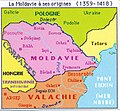 1359-1418.
 1418-1484.
 Under turkish vassality, 16-th century.
 1775-1856.
 1856-1878.
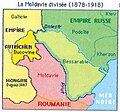 1878-1917.
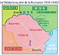 1918-1940, inside Romania.
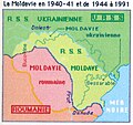 1940-1990 borders.
 Since 1991.


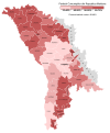 Votes won by the Communist Party of Moldova (PCRM) in the April 2009 legislative election by raion and municipality
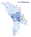 Votes won by the Liberal Party (PL) in the April 2009 legislative election by raion and municipality
 Votes won by the Liberal Democratic Party of Moldova (PLDM) in the April 2009 legislative election by raion and municipality
 Votes won by the 'Our Moldova' Alliance (AMN) in the April 2009 legislative election by raion and municipality
 Total votes won by the opposition parties (PL, PLDM and AMN) which passed the 6% electoral threshold in the April 2009 legislative election by raion and municipality
 Voter turnout for the April 2009 legislative election by raion and municipality
 Results of the July 2009 legislative election
 Results of the 2010 legislative election


 Harta etnică a Republicii Moldova la nivel de comune
 Ponderea românilor în Republica Moldova la nivel de comune
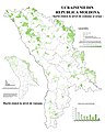 Ponderea ucrainenilor în Republica Moldova la nivel de comune
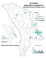 Ponderea rușilor în Republica Moldova la nivel de comune
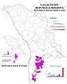 Ponderea găgăuzilor în Republica Moldova la nivel de comune
 Ponderea bulgarilor în Republica Moldova la nivel de comune


