File:Habsburg Map 1547.jpg
Rozmiar pierwotny (1654 × 1029 pikseli, rozmiar pliku: 534 KB, typ MIME: image/jpeg)
Podpisy
Podpisy
Opis[edytuj]
| Opis |
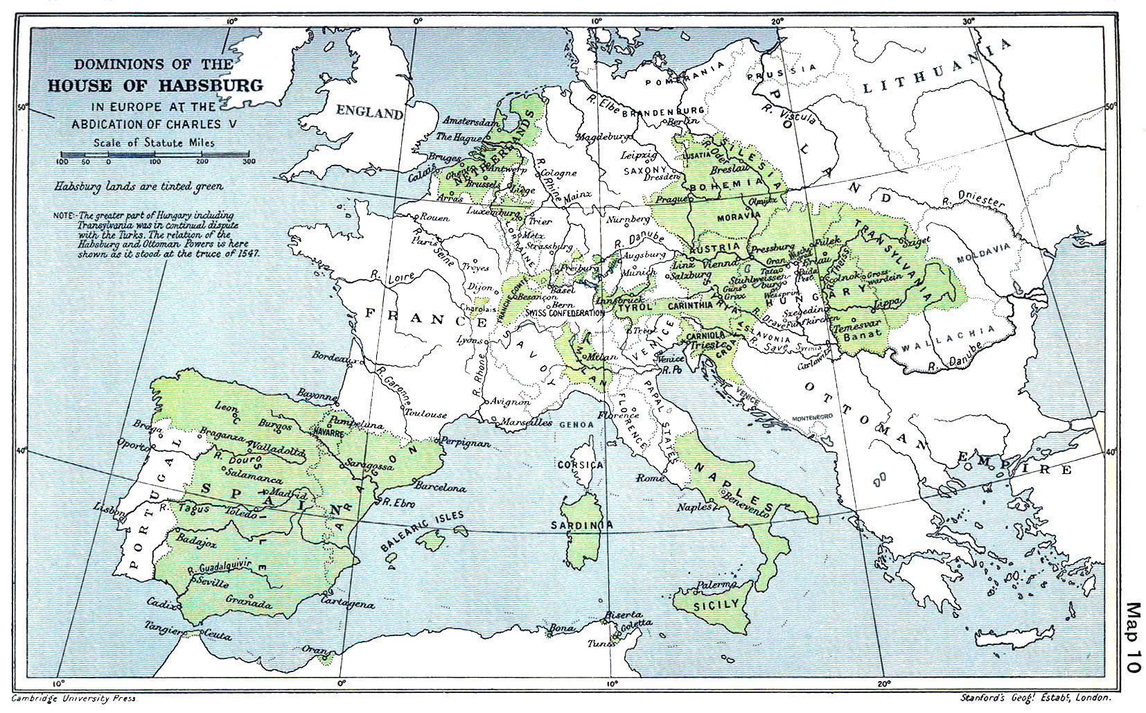
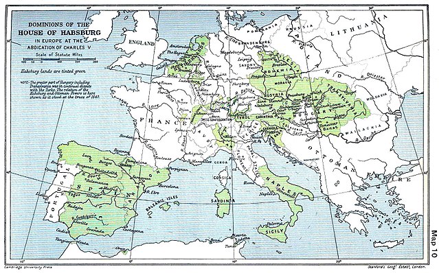
English: A map of the dominion of the Habsburgs following the Battle of Mühlberg (1547) |
| Data | |
| Źródło |
The Cambridge Modern History Atlas, edited by Sir Adolphus William Ward, G.W. Prothero, Sir Stanley Mordaunt Leathes, and E.A. Benians. Cambridge University Press: London, 1912. Editors were Sir Adolphus William Ward (†1924), G.W. Prothero (†1922), and Sir Stanley Mordaunt Leathes (†1938). Individual authors of works making up the atlas are not identified, nor are the likely to be, after reasonable research. |
| Autor | edited by Sir Adolphus William Ward, G.W. Prothero, Sir Stanley Mordaunt Leathes |
| Inne wersje |
|

Licencja[edytuj]
Powyższa praca jest własnością publiczną w Stanach Zjednoczonych, ponieważ została opublikowana (lub zarejestrowana w U.S. Copyright Office) przed 1 stycznia 1929.
Prace w domenie publicznej nie mogą podlegać prawu autorskiemu ani w Stanach Zjednoczonych ani w kraju pochodzenia, aby można je było umieścić na Commons. Jeśli ta praca nie pochodzi ze Stanów Zjednoczonych, plik musi mieć dodatkowe oznaczenia licencji wskazujące na jego status autorskoprawny w kraju pochodzenia.
|
This UK artistic or literary work, of which the author is unknown and cannot be ascertained by reasonable enquiry, is in the public domain because it is one of the following:
|
 |
Historia pliku
Kliknij na odpowiedniej dacie/czasie, aby zobaczyć wersję pliku z tamtego okresu.
| Data/czas | Miniatura | Wymiary | Użytkownik | Opis | |
|---|---|---|---|---|---|
| aktualny | 09:20, 29 mar 2018 | | 1654 × 1029 (534 KB) | Trecătorul răcit (dyskusja | edycje) | Little add: borders of the time |
| 11:01, 3 wrz 2015 |  | 1654 × 1029 (518 KB) | Kurzon (dyskusja | edycje) | Reverted to version as of 17:22, 9 August 2010 | |
| 11:01, 3 wrz 2015 |  | 1654 × 1029 (518 KB) | Kurzon (dyskusja | edycje) | Reverted to version as of 17:22, 9 August 2010 | |
| 21:33, 29 cze 2013 |  | 1654 × 1029 (546 KB) | CSvBibra (dyskusja | edycje) | add more contrast per request by another user | |
| 17:22, 9 sie 2010 |  | 1654 × 1029 (518 KB) | CSvBibra (dyskusja | edycje) | Previously put cleaned up version in new file with "b" after name. Now updating original file with "b" version. Both files uses throughout Wikipedias | |
| 09:07, 28 sie 2008 |  | 1654 × 1029 (649 KB) | F l a n k e r (dyskusja | edycje) | Wrap, shadows and minor improvements | |
| 14:42, 28 cze 2005 |  | 1654 × 1029 (421 KB) | Rythin~commonswiki (dyskusja | edycje) | A map of the dominion of the Habsburgs following the Battle of Mühlberg (1547). Taken from ''The Cambridge Modern History Atlas,'' edited by Sir Adolphus William Ward, G.W. Prothero, Sir Stanley Mordaunt Leathes, and E.A. Benians. Cambridge University Pr |
Nie możesz nadpisać tego pliku.
Lokalne wykorzystanie pliku
Następujące strony korzystają z tego pliku:
- Atlas of Austria
- Atlas of Belgium
- Atlas of European history
- Atlas of Galicia
- Atlas of Hungary
- Atlas of Italy
- Atlas of Luxembourg
- Atlas of Portugal
- Atlas of Slovenia
- Atlas of Spain
- Atlas of the Czech Republic
- Atlas of the Netherlands
- Maps of Austria
- User:J budissin/Uploads/BiH/2018 March 21-31
- File:Dominions House Habsburg abdication Charles V.jpg
Globalne wykorzystanie pliku
Ten plik jest wykorzystywany także w innych projektach wiki:
- Wykorzystanie na af.wikipedia.org
- Wykorzystanie na an.wikipedia.org
- Wykorzystanie na ar.wikipedia.org
- Wykorzystanie na arz.wikipedia.org
- Wykorzystanie na ast.wikipedia.org
- Wykorzystanie na azb.wikipedia.org
- Wykorzystanie na ba.wikipedia.org
- Wykorzystanie na be.wikipedia.org
- Wykorzystanie na bg.wikipedia.org
- Wykorzystanie na br.wikipedia.org
- Wykorzystanie na bs.wikipedia.org
- Wykorzystanie na ca.wikipedia.org
- Wykorzystanie na cs.wikipedia.org
- Wykorzystanie na da.wikipedia.org
- Wykorzystanie na de.wikipedia.org
- Wykorzystanie na el.wikipedia.org
Pokaż listę globalnego wykorzystania tego pliku.
Metadane
- 20th-century maps of Europe
- 1547
- Maps of 16th-century Europe
- Old maps of the Holy Roman Empire
- Maps of the history of Spain
- Austrian nobility ruling in Italy
- Nobility of Spain ruling in Italy
- Kingdom of Naples
- Maps of the Kingdom of Sicily
- Maps of the history of Sardinia
- Maps of the Habsburg Monarchy
- Austria in the 16th century
- 1912 maps
- Cambridge Modern History Atlas
- Relations of Austria and Spain