Die Republik Österreich ist ein Bundesstaat in Mitteleuropa. Es grenzt im Norden an Deutschland und Tschechien, im Osten an die Slowakei und Ungarn, im Süden an Slowenien und Italien und im Westen an die Schweiz und Liechtenstein.
Österreichische Bundesländer The States of Austria in German
Federal states, numbered
The States of Austria
Wien Vienna
Vorarlberg Vorarlberg
Tirol Tyrol
Steiermark Styria
Salzburg Salzburg
Oberösterreich Upper Austria
Niederösterreich Lower Austria
Kärnten Carinthia
Burgenland Burgenland
History maps
This section holds a short summary of the history of the area of present-day Austria, illustrated with maps, including historical maps of former countries and empires that included present-day Austria.
Possible extent of (proto-)Celtic influence 800-400 BC
Die Kelten in Europa. Ocker: Kernbereich Nordwestalpine Hallstattkultur (ca. 750–500/450 v. Chr.) grün: Ausbreitung La-Tène-Kultur, bzw. orange: der keltischen Sprache (3. Jh. v. Chr.)
Celts in Europe
Die Kelten in Europa
Map showing the pre-Migration Age distribution of the Germanic tribes in Proto-Germanic times, and stages of their expansion up to 50 BC, AD 100 and AD 300. The extent of the Roman Empire in 68 BC and AD 117 is also shown.
Proto-Germanische Völker
Territorial development of the Roman Empire 264 BC-192,
Territoriale Entwicklung des Römischen Reiches, inklusive die Eroberung des hießigen Österreichs
Roman Empire divided 395, showing the dioceses and praetorian prefectures of Gaul, Italy, Illyricum and Oriens (east), roughly analogous to the four Tetrarch zones of influence after Diocletian's reforms.
The division of the Empire after the death of Theodosius I, ca. 395 AD superimposed on modern borders.
Die Teilung des Römischen Reiches rund dem jahre 395.
Austria became an independent country after the dissolution of Austria-Hungary. This map shows the claims of German-Austria in 1918. The red lines are the real borders realized and presently.
The same map in English
Austria as part of Germany on August 31, 1939
idem
Administrative districts in territories under the control of Nazi Germany in 1941.
Großdeutschland im Jahre 1941
Eastern front of the Second World War circa 1941-1942.
Austria under allied occupation
Old maps
This section holds copies of original general maps more than 70 years old.
Other maps
Extreme points
Comparison of Area with a circle
Breweries in Austria
German dialects
Church provinces
Election to Nationalrat 2006
Traffical Regions (Verkehrsverbünde)
Justizanstalten
Dioceses
Dioceses of Austria
Diocese Eisenstadt (Burgenland)
Archdiocese Wien (Vienna and part of Lower Austria)
Archdiocese Wien (Vienna - history)
Diocese St. Pölten (part of Lower Austria)
Diocese Linz (Upper Austria)
Archdiocese Salzburg
Diocese Innsbruck (Tirol)
Diocese Feldkirch (Vorarlberg)
Diocese Graz-Seckau (Styria)
Diocese Gurk (Carinthia)
Diocese Leoben (Styria)
Ecclesiastical province Salzburg
Ecclesiastical province Vienna
Dioceses of Austria about 1300
Dioceses of Austria about 1850
Dioceses of Austria since 1968
Satellite maps
Satellite map
Satellite map
Satellite map
Satellitemap of Austria
Satellitemap of Austria Landsat with boundaries of the "Bundesländer"
Satellitemap with boundaries of the "Bundesländer"
Satellitemap with boundaries of the "Grosslandschaften"
Notes and references
General remarks:
The WIKIMEDIA COMMONS Atlas of the World is an organized and commented collection of geographical, political and historical maps available at Wikimedia Commons. The main page is therefore the portal to maps and cartography on Wikimedia. That page contains links to entries by country, continent and by topic as well as general notes and references.
Every entry has an introduction section in English. If other languages are native and/or official in an entity, introductions in other languages are added in separate sections. The text of the introduction(s) is based on the content of the Wikipedia encyclopedia. For sources of the introduction see therefore the Wikipedia entries linked to. The same goes for the texts in the history sections.
Historical maps are included in the continent, country and dependency entries.
The status of various entities is disputed. See the content for the entities concerned.
The maps of former countries that are more or less continued by a present-day country or had a territory included in only one or two countries are included in the atlas of the present-day country. For example the Ottoman Empire can be found in the Atlas of Turkey.


 Österreichische Bundesländer
 Federal states, numbered
 The States of Austria


 Wien
Wien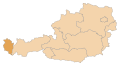 Vorarlberg
 Tirol
Tirol Steiermark
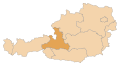 Salzburg
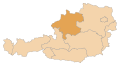 Oberösterreich
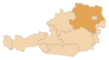 Niederösterreich
 Kärnten
 Burgenland


.PNG)


-en.png)
-de.png)


.jpg)
.JPG)


 Dioceses of Austria
 Diocese Eisenstadt (Burgenland)
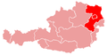 Archdiocese Wien (Vienna and part of Lower Austria)
 Archdiocese Wien (Vienna - history)
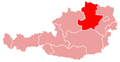 Diocese St. Pölten (part of Lower Austria)
 Diocese Linz (Upper Austria)
 Archdiocese Salzburg
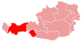 Diocese Innsbruck (Tirol)
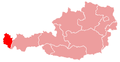 Diocese Feldkirch (Vorarlberg)
 Diocese Graz-Seckau (Styria)
 Diocese Gurk (Carinthia)
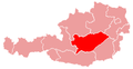 Diocese Leoben (Styria)
 Ecclesiastical province Salzburg
 Ecclesiastical province Vienna
 Dioceses of Austria about 1300
 Dioceses of Austria about 1850
 Dioceses of Austria since 1968


