File:Map of the route of Edward III's chevauchée of 1346.svg: Difference between revisions

From Wikimedia Commons, the free media repository
Jump to navigation Jump to search
Content deleted Content added
Add sources
Line 4: Line 4:
|date =2019-03-06
|date =2019-03-06
|source ={{Own}}<br>
|source ={{Own}}<br>
Derived from;
Derived from:<br />
*Sumption, Jonathan (1990). Trial by Battle. The Hundred Years' War. I. London: Faber and Faber. {{ISBN|978-0571200955}}. p. 505.<br />
* [https://www.openstreetmap.org/#map=8/49.919/1.371 OSM]
*Livingstone, Marilyn; Witzel, Morgen (2005). The Road to Crécy: The English Invasion of France, 1346. Harlow: Pearson Education. ISBN 978-0582784208. pp. 107–225.
Information from:
* [https://www.themaparchive.com/the-crecy-campaign-12-july-to-4-september-1346.html themaparchive.com]
*
* {{U|Newm30}}
|author ={{U|Goran tek-en}}, following request by {{U|Newm30}}
|author ={{U|Goran tek-en}}, following request by {{U|Newm30}}
|permission ={{Cc-by-sa-4.0 |1= Goran tek-en}}
|permission ={{Cc-by-sa-4.0 |1= Goran tek-en}}

Revision as of 13:01, 18 May 2019

Captions

Captions

Add a one-line explanation of what this file represents

Summary

Description
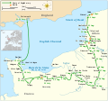
English: Map of the route of Edward III's chevauchée of 1346, part of the Hundred Years' War. This map shows the English army movements during the campaign and the most important battles.
Date
Source

Own work
Derived from:

  • Sumption, Jonathan (1990). Trial by Battle. The Hundred Years' War. I. London: Faber and Faber. ISBN 978-0571200955. p. 505.
  • Livingstone, Marilyn; Witzel, Morgen (2005). The Road to Crécy: The English Invasion of France, 1346. Harlow: Pearson Education. ISBN 978-0582784208. pp. 107–225.
  • themaparchive.com
Author Goran tek-en, following request by Newm30
Permission
(Reusing this file)
w:en:Creative Commons
attribution share alike
This file is licensed under the Creative Commons Attribution-Share Alike 4.0 International license.
Attribution: Goran tek-en
You are free:
  • to share – to copy, distribute and transmit the work
  • to remix – to adapt the work
Under the following conditions:
  • attribution – You must give appropriate credit, provide a link to the license, and indicate if changes were made. You may do so in any reasonable manner, but not in any way that suggests the licensor endorses you or your use.
  • share alike – If you remix, transform, or build upon the material, you must distribute your contributions under the same or compatible license as the original.

Template:NO Facebook Youtube license

This work contains information from OpenStreetMap, which is made available under the Open Database License (ODbL).

The ODbL does not require any particular license for maps produced from ODbL data. Prior to 1 August 2020, map tiles produced by the OpenStreetMap Foundation were licensed under the CC-BY-SA-2.0 license. Maps produced by other people may be subject to other licences.

SVG development
InfoField
 
The SVG code is valid.
 
This map was created with an unknown SVG tool.
 
 This map uses embedded text that can be easily translated using a text editor.

File history

Click on a date/time to view the file as it appeared at that time.

Date/TimeThumbnailDimensionsUserComment
current00:14, 3 February 2022Thumbnail for version as of 00:14, 3 February 20221,059 × 988 (450 KB)Iso10970 (talk | contribs)Reverted to version as of 13:17, 9 November 2021 (UTC)
00:13, 3 February 2022Thumbnail for version as of 00:13, 3 February 20221,059 × 988 (614 KB)Iso10970 (talk | contribs)File uploaded using svgtranslate tool (https://svgtranslate.toolforge.org/). Added translation for ja.
13:17, 9 November 2021Thumbnail for version as of 13:17, 9 November 20211,059 × 988 (450 KB)Goran tek-en (talk | contribs)Changed view box, font size, added location map
13:06, 14 April 2019Thumbnail for version as of 13:06, 14 April 20191,059 × 988 (191 KB)Goran tek-en (talk | contribs)Spelling
17:53, 10 March 2019Thumbnail for version as of 17:53, 10 March 20191,059 × 988 (115 KB)JoKalliauer (talk | contribs)phab:T36947 bad character aligment on same sizes
14:08, 6 March 2019Thumbnail for version as of 14:08, 6 March 20191,059 × 988 (191 KB)Goran tek-en (talk | contribs){{Information |description ={{en|1=Map of the route of Edward III's chevauchée of 1346, part of the Hundred Years' War. This map shows the English army movements during the campaign and the most important battles.}} |date =20190306 |source ={{Own}}<br> Derived from; * [https://www.openstreetmap.org/#map=8/49.919/1.371 OSM] Information from: * [https://www.themaparchive.com/the-crecy-campaign-12-july-to-4-september-1346.html themaparchive.com] * {{U|Newm30}} |author...

File usage on other wikis

Metadata