Category:1830s maps of Georgia (U.S. state)
Jump to navigation
Jump to search
States of the United States: Alabama · Alaska · Arizona · Arkansas · California · Connecticut · Delaware · Florida · Georgia · Hawaii · Illinois · Indiana · Iowa · Kansas · Kentucky · Louisiana · Maine · Maryland · Massachusetts · Michigan · Mississippi · Missouri · Nebraska · Nevada · New Hampshire · New Jersey · New York · Ohio · Oklahoma · Pennsylvania · Rhode Island · South Carolina · Tennessee · Texas · Utah · Vermont · Virginia
Puerto Rico
Puerto Rico
Subcategories
This category has only the following subcategory.
Media in category "1830s maps of Georgia (U.S. state)"
The following 5 files are in this category, out of 5 total.
-
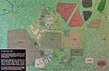 19-34-001-vann.jpg 3,248 × 2,150; 1.95 MB
-
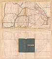
 Cherokeenation1830map.jpg 576 × 426; 74 KB
-
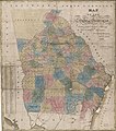
 Georgia, from the latest authorities. LOC 2010587363.jpg 4,536 × 5,105; 3.57 MB
-

-