Category:1896 maps of New Jersey
Jump to navigation
Jump to search
States of the United States: California · Connecticut · Georgia · Idaho · Illinois · Iowa · Kansas · Kentucky · Louisiana · Maine · Massachusetts · Michigan · Minnesota · Mississippi · Missouri · Montana · New Hampshire · New Jersey · New York · North Carolina · North Dakota · Ohio · Oklahoma · Oregon · Pennsylvania · Rhode Island · South Carolina · South Dakota · Tennessee · Texas · Virginia · Washington · West Virginia · Wisconsin · Wyoming – Washington, D.C.
| ← 1890 1891 1892 1895 1896 1897 1898 1899 → |
Subcategories
This category has the following 15 subcategories, out of 15 total.
S
Media in category "1896 maps of New Jersey"
The following 11 files are in this category, out of 11 total.
-

-
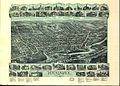 Hackensack 1896.jpg 2,508 × 1,788; 1.32 MB
-
 Hackensack, New Jersey LOC 80693464.jpg 10,032 × 7,152; 19.32 MB
-
 Manual of the Legislature of New Jersey (1896) (14773016851).jpg 1,576 × 2,492; 504 KB
-
 Sanborn Fire Insurance Map from Netcong, Morris County, New Jersey. LOC sanborn05564 001.jpg 6,450 × 7,650; 3.76 MB
-
 Sanborn Fire Insurance Map from Netcong, Morris County, New Jersey. LOC sanborn05564 001.tif 6,450 × 7,650; 141.17 MB
-

-
 Sanborn Fire Insurance Map from Ridgewood, Bergen County, New Jersey. LOC sanborn05612 001.tif 6,450 × 7,650; 141.17 MB
-

-
 Sanborn Fire Insurance Map from Stanhope, Sussex County, New Jersey. LOC sanborn05632 002.tif 6,450 × 7,650; 141.17 MB
-


_(14773016851).jpg)


_(14773356081).jpg)
_1896_map_from_the_Sanborn_Fire_Insurance_Map_from_Rahway,_Union_County,_New_Jersey._LOC_sanborn05607_003-15_(cropped).jpg)