Category:1896 maps of Rhode Island
Jump to navigation
Jump to search
States of the United States: California · Connecticut · Georgia · Idaho · Illinois · Iowa · Kansas · Kentucky · Louisiana · Maine · Massachusetts · Michigan · Minnesota · Mississippi · Missouri · Montana · New Hampshire · New Jersey · New York · North Carolina · North Dakota · Ohio · Oklahoma · Oregon · Pennsylvania · Rhode Island · South Carolina · South Dakota · Tennessee · Texas · Virginia · Washington · West Virginia · Wisconsin · Wyoming – Washington, D.C.
| ← 1890 1891 1892 1894 1895 1896 1897 1898 1899 → |
Subcategories
This category has the following 3 subcategories, out of 3 total.
Media in category "1896 maps of Rhode Island"
The following 4 files are in this category, out of 4 total.
-

-
 Sanborn Fire Insurance Map from Manville, Providence County, Rhode Island. LOC sanborn08088 001.tif 6,450 × 7,650; 141.17 MB
-
-
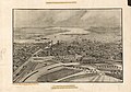
 View of the city of Providence as seen from the dome of the new State House. LOC 75696565.tif 7,048 × 4,920; 99.21 MB

