Category:Ardnave Point
point on the northwest coast of Islay, Argyll and Bute, Scotland, UK  | |||||
| Upload media | |||||
| Instance of | |||||
|---|---|---|---|---|---|
| Location | Argyll and Bute, Scotland | ||||
 | |||||
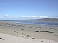
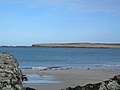
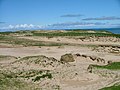
Ardnave Point or Ardnave Peninsula is a peninsula of northwest Islay. Off its western shore is Nave Island. Beyond its eastern shore is Loch Gruinart. At its base is Ardnave and Ardnave Loch. The point is mainly dunes and moorland, some of it covered with replanted grass, with no eminent elevations. A knoll at the tip is called Cnoc na Faire, "lookout hill." A beach north of Ardnave is Tràigh Nostaig. Further north is Tràigh nam Fuaran. Around the coast of the point west to east are a sequence of named inlets: Port nam Muileach, Port Cnoc na Faire, Port Domhain, Port nam Beindag, Port nam Marbh, and after a small point, Sgeir na Nighinn, is Port na Feamainn, in the very mouth of Loch Gruinart. From most of Ardnave Point it is possible to survey most of the coast of north Islay. Beyond the visible hills is the Sound of Islay, with the Paps of Jura protruding above the hills.
Subcategories
This category has the following 5 subcategories, out of 5 total.
P
- Port Bhreac-achaidh (3 F)
S
- Sloc na Glaisrig (1 F)
- Sloc na Maoile (5 F)
T
- Tràigh nam Fuaran (5 F)
- Tràigh Nostaig (6 F)
Media in category "Ardnave Point"
The following 25 files are in this category, out of 25 total.
-
 Approaching Killinallan Point - geograph.org.uk - 756033.jpg 640 × 480; 22 KB
-
 Ardnave Point - geograph.org.uk - 756684.jpg 640 × 480; 67 KB
-
 Ardnave Point - geograph.org.uk - 756687.jpg 640 × 430; 36 KB
-
 Ardnave Shingle - geograph.org.uk - 1779151.jpg 640 × 476; 125 KB
-
 Ardnave View - geograph.org.uk - 1163276.jpg 640 × 394; 70 KB
-
 Ardnave View - geograph.org.uk - 1166200.jpg 640 × 402; 109 KB
-
 Ardnave's Sand Dunes - geograph.org.uk - 705360.jpg 640 × 480; 75 KB
-
 Ardnavept.jpg 640 × 480; 186 KB
-

-
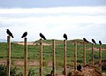 Choughs at Ardnave - geograph.org.uk - 409853.jpg 640 × 461; 110 KB
-
 Dunes At Ardnave Point - geograph.org.uk - 1166211.jpg 640 × 402; 97 KB
-
 Layers In The Dunes - geograph.org.uk - 1166205.jpg 640 × 348; 86 KB
-
 Loch Gruinart - geograph.org.uk - 193882.jpg 640 × 480; 72 KB
-
 Nave Island - geograph.org.uk - 349799.jpg 640 × 480; 92 KB
-
 Nave Island from Ardnave Point - geograph.org.uk - 756686.jpg 480 × 640; 49 KB
-
 Nave Island, Islay - geograph.org.uk - 340975.jpg 640 × 428; 131 KB
-
 Port nam Beindag - geograph.org.uk - 705384.jpg 640 × 458; 82 KB
-
 Rocks At Ardnave Point - geograph.org.uk - 1166209.jpg 640 × 426; 108 KB
-
 Sand Dunes, Ardnave Point - geograph.org.uk - 15564.jpg 640 × 480; 100 KB
-
 The shoreline, Ardnave Point - geograph.org.uk - 756688.jpg 640 × 480; 71 KB
-
 The track to Port na Muic - geograph.org.uk - 756356.jpg 640 × 480; 76 KB
-
 Towards Nave Island - geograph.org.uk - 1163264.jpg 640 × 380; 63 KB
-
 Towards Nave Island - geograph.org.uk - 1166215.jpg 640 × 410; 91 KB
-
 Towards Sgeirean Leathann - geograph.org.uk - 1166218.jpg 640 × 411; 87 KB
-


