Category:Grade II listed buildings in Tyne and Wear
Jump to navigation
Jump to search
Ceremonial counties of England: Bedfordshire · Berkshire · Buckinghamshire · Cambridgeshire · Cheshire · Cornwall · Cumbria · Derbyshire · Devon · Dorset · Durham · East Riding of Yorkshire · East Sussex · Essex · Gloucestershire · Greater London · Greater Manchester · Hampshire · Herefordshire · Hertfordshire · Kent · Lancashire · Leicestershire · Lincolnshire · Merseyside · Norfolk · North Yorkshire · Northamptonshire · Northumberland · Nottinghamshire · Oxfordshire · Rutland · Shropshire · Somerset · South Yorkshire · Staffordshire · Suffolk · Surrey · Tyne and Wear · Warwickshire · West Midlands · West Sussex · West Yorkshire · Wiltshire · Worcestershire
City-counties: Bristol · City of London
Former historic counties: Westmorland ·
Other former counties:
City-counties: Bristol · City of London
Former historic counties: Westmorland ·
Other former counties:
Wikimedia category | |||||
| Upload media | |||||
| Instance of | |||||
|---|---|---|---|---|---|
| |||||
Subcategories
This category has the following 41 subcategories, out of 41 total.
A
C
- Cleadon Mill (4 F)
- Cullercoats Fishermans Lookout (14 F)
- Cullercoats lifeboat station (18 F)
G
- Gateshead Dispensary (7 F)
- Felling Town Hall (2 F)
- Gateshead Old Town Hall (16 F)
- Grainger Memorial Fountain (11 F)
H
- Hawksley House, Sunderland (2 F)
J
- Jesmond Dene Banqueting Hall (8 F)
- Jesmond Dene Mill (31 F)
L
- The Peacock, Sunderland (5 F)
M
- Mackie's Corner, Sunderland (3 F)
- Manors Power Station (10 F)
- Master Mariners Homes (8 F)
O
- Old Gateshead Library (6 F)
P
- Priestman Hall (4 F)
S
- South Shields Town Hall (36 F)
- St. Mary's Lighthouse (146 F)
- Sunderland Magistrates' Court (15 F)
- Sunderland Synagogue (2 F)
T
- Trafalgar Square, Sunderland (5 F)
W
- Wallsend Town Hall (2 F)
Media in category "Grade II listed buildings in Tyne and Wear"
The following 46 files are in this category, out of 46 total.
-
 1 Howard Street, North Shields, Tyne and Wear.tif 5,445 × 3,631; 75.45 MB
-
 22-Blackett-Street.png 1,728 × 2,592; 5.04 MB
-
 47a Percy Gardens Tynemouth.jpeg 3,456 × 5,184; 8.24 MB
-
 Akhurst School (Jesmond Cottage) And Gas Lamp At Door.jpg 4,032 × 3,024; 5.34 MB
-
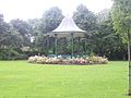 Bandstand - Mowbray Park.JPG 3,056 × 2,292; 1,007 KB
-
 Bede Memorial Cross, Sunderland.jpg 3,168 × 4,752; 7.48 MB
-
 Bridge Hotel Sunderland 1.jpg 5,184 × 3,888; 5.88 MB
-
 Bridge hotel.jpg 3,996 × 4,000; 8.48 MB
-
 Carter's Well, Durham Road, Low Fell.JPG 3,264 × 2,448; 2.03 MB
-
 Church Street, Houghton-le-Spring - geograph.org.uk - 2584004.jpg 640 × 480; 68 KB
-
 Claremont Buildings.jpg 2,048 × 1,536; 964 KB
-
 Corder House and Sydenham House.jpg 1,690 × 2,270; 455 KB
-
 Deuchar House, Jesmond, Newcastle upon Tyne.jpg 2,048 × 1,536; 1 MB
-
 Entrance to the churchyard - geograph.org.uk - 3572101.jpg 3,648 × 2,736; 3.1 MB
-
 Former Boiler House, Sandyford Brewery, Newcastle upon Tyne.jpg 2,048 × 1,536; 958 KB
-

-
 Former Newcastle Breweries Offices.jpg 2,048 × 1,536; 1.08 MB
-
 Lych Gate, St Andrew's Roker - geograph.org.uk - 2366786.jpg 1,824 × 1,368; 1.25 MB
-
 Maritime Chambers - geograph.org.uk - 5197.jpg 640 × 480; 161 KB
-
 Milburn House, Newcastle upon Tyne.jpg 3,024 × 4,032; 3.58 MB
-
 Newcastle upon Tyne - St Mary's Well, Jesmond - 20230924172954.jpg 3,468 × 4,624; 7.7 MB
-
 Former synagogue, Leazes Park Road (geograph 1674759).jpg 1,024 × 768; 287 KB
-
 North Tyneside - Sewer Gas Lamp - 20220910113614.jpg 3,024 × 4,032; 2.28 MB
-
 North Tyneside - Sewer Gas Lamp - 20220910114106.jpg 3,024 × 4,032; 2.64 MB
-
 Octagon, Seaton Sluice.JPG 3,264 × 2,448; 2.59 MB
-
 Ornate Clock, Gateshead - geograph.org.uk - 994877.jpg 640 × 427; 59 KB
-
 P4020133.JPG 4,288 × 3,216; 3.46 MB
-
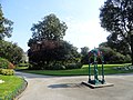 Paths in Mowbray Park, Sunderland (geograph 5362999).jpg 4,608 × 3,456; 5.82 MB
-
 Phoenix House, Newcastle Quayside & The Tyne Bridge.tiff 2,840 × 2,000; 16.29 MB
-
 Phoenix House, Newcastle upon Tyne.jpg 4,032 × 3,024; 4.11 MB
-
 Plaque on 1, Howard Street, North Shields, Tyne and Wear.tif 5,375 × 3,513; 54.05 MB
-
 Saltgrass Sunderland with drinking fountain 02.jpg 1,224 × 918; 248 KB
-
 Saltgrass Sunderland with drinking fountain 03.jpg 688 × 918; 173 KB
-
 Saltwell Towers, Saltwell Park, Gateshead (geograph 2319658).jpg 600 × 450; 303 KB
-
 St. Mary’s Well, Jesmond, Newcastle upon Tyne.jpg 1,536 × 2,048; 1.26 MB
-
 SunderlandWinterGardens.jpg 1,000 × 1,500; 809 KB
-
 The Literary Rooms, Durham Road, Low Fell.JPG 3,264 × 2,448; 1.94 MB
-
 The Lodge, Newcastle upon Tyne.jpg 2,048 × 1,536; 961 KB
-
 Trafalgar Square, Sunderland 1.jpg 3,552 × 2,000; 2.05 MB
-
 Traflgar square Lamp and Mast.jpg 1,177 × 883; 354 KB
-
 Tynemouth VLB Watch House.jpg 5,376 × 3,024; 4.53 MB
-
 Walbottle Hall - geograph.org.uk - 738135.jpg 640 × 480; 77 KB
-
 Watch House Tynemouth 1184976.jpg 5,988 × 3,994; 5.86 MB
-
 Whitley Bay Station1.JPG 3,264 × 2,448; 3.08 MB
-
 William Hall Drinking Fountain.jpg 2,292 × 3,056; 964 KB
-
 Windmill Chimney Mills Spital Tongues.jpg 1,198 × 2,048; 229 KB


_And_Gas_Lamp_At_Door.jpg)


.jpg)


.jpg)


.jpg)


