Category:Kyrgyzstan
Jump to navigation
Jump to search
Countries of Asia: Afghanistan · Armenia‡ · Azerbaijan‡ · Bahrain · Bangladesh · Bhutan · Brunei Darussalam · Cambodia · People's Republic of China · Cyprus‡ · East Timor · Egypt‡ · Georgia‡ · India · Indonesia‡ · Iran · Iraq · Israel · Japan · Jordan · Kazakhstan‡ · Kuwait · Kyrgyzstan · Laos · Lebanon · Malaysia · Maldives · Mongolia · Myanmar · Nepal · North Korea · Oman · Pakistan · Philippines · Qatar · Russia‡ · Saudi Arabia · Singapore · South Korea · Sri Lanka · Syria · Tajikistan · Thailand · Turkey‡ · Turkmenistan · United Arab Emirates · Uzbekistan · Vietnam · Yemen
Limited recognition: Abkhazia‡ · Taiwan · Northern Cyprus‡ · State of Palestine · South Ossetia‡ – Other territories: Akrotiri and Dhekelia‡ · British Indian Ocean Territory · Hong Kong · Macau
‡: partly located in Asia
Limited recognition: Abkhazia‡ · Taiwan · Northern Cyprus‡ · State of Palestine · South Ossetia‡ – Other territories: Akrotiri and Dhekelia‡ · British Indian Ocean Territory · Hong Kong · Macau
‡: partly located in Asia
sovereign state in Central Asia .svg)   .svg) | |||||
| Upload media | |||||
| Pronunciation audio | |||||
|---|---|---|---|---|---|
| Instance of |
| ||||
| Culture | |||||
| Location |
| ||||
| Capital | |||||
| Basic form of government |
| ||||
| Legislative body | |||||
| Executive body | |||||
| Official language | |||||
| Anthem | |||||
| Currency | |||||
| Head of state |
| ||||
| Head of government |
| ||||
| Inception |
| ||||
| Highest point | |||||
| Population |
| ||||
| Area |
| ||||
| Follows | |||||
| Replaces | |||||
| Top-level Internet domain | |||||
| official website | |||||
 | |||||
Čeština: Kyrgyzstán je stát ve Střední Asii. Sousedí s Kazachstánem, Čínou, Tadžikistánem a Uzbekistánem. Hlavním městem je Biškek.
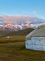
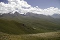
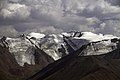
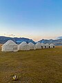
English: Kyrgyzstan, officially the Kyrgyz Republic, is a country in Central Asia. It is bordered by Kazakhstan to the north, Uzbekistan to the west, Tajikistan to the southwest and China to the east. Its capital is Bishkek.
हिन्दी : किर्गिज़स्तान, आधिकारिक रूप से किर्गिज़ गणराज्य, मध्य एशिया में एक देश है। इसके उत्तर में कज़ाख़िस्तान, पश्चिम में उज़्बेकिस्तान, दक्षिण-पश्चि में ताजीकिस्तान और पूर्व में चीन स्थित हैं। इसकी राजधानी बिश्केक है।

Subcategories
This category has the following 18 subcategories, out of 18 total.
!
?
A
D
G
H
I
K
- Kirgiz (Zieliński) (50 F)
M
- Manhole covers in Kyrgyzstan (1 F)
N
S
V
~
- Wikivoyage banners of Kyrgyzstan (25 F)
Media in category "Kyrgyzstan"
The following 200 files are in this category, out of 283 total.
(previous page) (next page)-
De-Kirgisistan2.ogg 2.3 s; 22 KB
-
 "Караван" научно-исследовательской геологической экспедиции в горах Киргизии.JPG 2,592 × 1,944; 3.22 MB
-
 . - panoramio (661).jpg 2,592 × 1,728; 1.35 MB
-
 130509-F-QV958-030 (8802342009).jpg 3,965 × 2,832; 3.3 MB
-
 2010 ethnic clashes Uzbek Kyrgyz.png 648 × 428; 600 KB
-
 26 June 2012 Боом - panoramio (1).jpg 1,600 × 1,200; 320 KB
-
 26 June 2012 Боом - panoramio (2).jpg 1,600 × 1,200; 272 KB
-
 A yurt against the backdrop of snow-capped mountains.jpg 3,024 × 4,032; 1.83 MB
-
 Abandoned memorial site near Tosor, Kyrgyzstan - panoramio (1).jpg 4,000 × 3,000; 1.47 MB
-
 Abandoned memorial site near Tosor, Kyrgyzstan - panoramio.jpg 4,000 × 3,000; 1.16 MB
-
 Ak-DebeAA.png 2,230 × 2,530; 80 KB
-
 Ala-Bel pass, Kyrgyzstan (42689781400).jpg 3,239 × 2,161; 3.73 MB
-
 Ala-Bel pass, Kyrgyzstan (43589156985).jpg 3,317 × 2,110; 3.72 MB
-
 Ala-Bel pass, Kyrgyzstan (43781212604).jpg 3,700 × 1,891; 4.49 MB
-
 Ala-Bel pass, Kyrgyzstan (44499508561).jpg 3,419 × 2,047; 3.92 MB
-
-
 Application of sawdust (5735842683).jpg 355 × 200; 41 KB
-
 Arashan.jpg 1,170 × 712; 641 KB
-
 Arslanbob pano.jpg 4,411 × 630; 1.61 MB
-
 Balykchy.jpg 3,000 × 4,000; 3.55 MB
-
 Barbara Kellner-Heinkele. PIAC in Bishkek. 27.8.2018.jpg 2,714 × 1,932; 975 KB
-
 Bash-Kuugandy, cemetery, Kyrgyzstan - panoramio.jpg 3,953 × 2,968; 3.3 MB
-
 Bash-Kuugandy, Kyrgyzstan - panoramio (1).jpg 3,822 × 2,871; 2.33 MB
-
 Bash-Kuugandy, Kyrgyzstan - panoramio.jpg 4,453 × 3,343; 2.86 MB
-
 Bekten Beishembiev.png 373 × 356; 69 KB
-
 Bermet Bakytbekova 2.jpg 1,174 × 2,029; 366 KB
-
 Bermet Bakytbekova.jpg 891 × 2,080; 380 KB
-
 Blank Kyrgyzstan Map.png 3,200 × 1,600; 326 KB
-
 Climbing Tastar-Ata (3.847m) (14939343909).jpg 5,184 × 3,456; 2.39 MB
-
 Climbing Tastar-Ata (3.847m) (14939343999).jpg 5,184 × 3,456; 1.61 MB
-
 Climbing Tastar-Ata (3.847m) (14939479888).jpg 5,184 × 3,456; 2.3 MB
-
 Climbing Tastar-Ata (3.847m) (14939481828).jpg 5,184 × 3,456; 1.54 MB
-
 Climbing Tastar-Ata (3.847m) (14939481958).jpg 5,184 × 3,456; 1.59 MB
-
 Climbing Tastar-Ata (3.847m) (14939482217).jpg 5,149 × 2,923; 1.39 MB
-
 Climbing Tastar-Ata (3.847m) (14939482268).jpg 5,184 × 3,456; 1.87 MB
-
 Climbing Tastar-Ata (3.847m) (14939482748).jpg 5,184 × 3,456; 1.11 MB
-
 Climbing Tastar-Ata (3.847m) (14939482858).jpg 5,184 × 3,456; 1.58 MB
-
 Climbing Tastar-Ata (3.847m) (14939483077).jpg 5,184 × 3,309; 1.28 MB
-
 Climbing Tastar-Ata (3.847m) (14939483158).jpg 5,184 × 3,456; 1.4 MB
-
 Climbing Tastar-Ata (3.847m) (15103048926).jpg 5,184 × 3,456; 1.14 MB
-
 Climbing Tastar-Ata (3.847m) (15103049106).jpg 5,184 × 3,456; 1.65 MB
-
 Climbing Tastar-Ata (3.847m) (15103049576).jpg 5,184 × 3,456; 1.74 MB
-
 Climbing Tastar-Ata (3.847m) (15103049976).jpg 5,184 × 3,456; 2.25 MB
-
 Climbing Tastar-Ata (3.847m) (15103050996).jpg 5,184 × 3,456; 1.95 MB
-
 Climbing Tastar-Ata (3.847m) (15103052306).jpg 5,184 × 3,456; 1.28 MB
-
 Climbing Tastar-Ata (3.847m) (15123046191).jpg 5,184 × 3,456; 1.28 MB
-
 Climbing Tastar-Ata (3.847m) (15123046821).jpg 5,184 × 3,456; 1.98 MB
-
 Climbing Tastar-Ata (3.847m) (15123047981).jpg 5,184 × 3,456; 1.41 MB
-
 Climbing Tastar-Ata (3.847m) (15123048091).jpg 5,184 × 3,456; 1.31 MB
-
 Climbing Tastar-Ata (3.847m) (15125667042).jpg 5,184 × 3,456; 2.12 MB
-
 Climbing Tastar-Ata (3.847m) (15125667412).jpg 5,184 × 3,456; 1.82 MB
-
 Climbing Tastar-Ata (3.847m) (15125667582).jpg 5,184 × 3,456; 2.03 MB
-
 Climbing Tastar-Ata (3.847m) (15125668152).jpg 5,184 × 3,456; 1.72 MB
-
 Climbing Tastar-Ata (3.847m) (15125669872).jpg 5,184 × 3,456; 1.48 MB
-
 Climbing Tastar-Ata (3.847m) (15126044835).jpg 5,184 × 3,456; 1.52 MB
-
 Climbing Tastar-Ata (3.847m) (15126044975).jpg 5,184 × 3,456; 1.66 MB
-
 Coat of arms of Kaindy, Panfilov.png 686 × 686; 675 KB
-
 Coat of arms of Toktogul rayon ver2.png 1,552 × 1,760; 2.62 MB
-
 Constructing the school UDDTs (5735842459).jpg 260 × 300; 61 KB
-
 Dark blue armband of the Tourist Police of Kyrgyzstan.jpg 1,631 × 1,080; 286 KB
-
De-Kirgisien.ogg 2.0 s; 18 KB
-
 Democracy - a tree without roots on the steppes of Central Asia (IA democracytreewit109452376).pdf 1,275 × 1,650, 108 pages; 648 KB
-
 Demographics of Kyrgyzstan (1950-2018).svg 882 × 505; 30 KB
-
 Dilnaz Sazanova 2.jpg 1,040 × 1,783; 368 KB
-
 Dzhmak-Echku valley, near Son-Kul lake, Kyrgyzstan - panoramio.jpg 4,029 × 3,023; 2.43 MB
-
 Dzhmak-Echku valley, Son-Kol, Kyrgyzstan - panoramio.jpg 3,610 × 2,708; 1.15 MB
-
 EAEU GDP per capita.svg 1,281 × 641; 168 KB
-
 Fire fight (13085537743).jpg 5,705 × 3,556; 7.18 MB
-
 From Sary Tash to Osh, Kyrgyzstan (43464443765).jpg 3,240 × 2,160; 6.91 MB
-
 GMW Kyrgyzstan.jpg 4,354 × 2,607; 2.48 MB
-
 Gnadental9618.jpg 900 × 561; 76 KB
-
 Hiking Kyrgyzstan.jpg 6,000 × 4,000; 17.71 MB
-
 Hory kirgizsko4.jpg 4,032 × 3,024; 5.28 MB
-
 Hory kirgizstan3.jpg 4,032 × 3,024; 4.98 MB
-
 Images.faculties.1etf.obshay informacia.01 KRSY 600x359.jpg 600 × 359; 82 KB
-
 Implementation and Impact of LP in Kyrgyzstan.pdf 1,072 × 1,516, 32 pages; 713 KB
-
 International Village Kyrgyzstan (Alilz x Bek).jpg 3,999 × 3,000; 1.82 MB
-
 International Village Kyrgyzstan 2 (Alilz x Bek).jpg 3,999 × 3,000; 2.26 MB
-
 ISS006-E-16018 - View of China.jpg 3,032 × 2,064; 1.03 MB
-
 Kara-Kehe open pit coal mine, Kyrgyzstan - panoramio (1).jpg 4,095 × 3,074; 2.58 MB
-
 Kattama in Kyrgyzstan.jpg 960 × 1,280; 329 KB
-
 Kenzhebek Omuraliev.jpg 619 × 619; 25 KB
-
 Kerben Airport ATC.jpg 5,472 × 3,072; 5.63 MB
-
 Kirgise mit Falke oder Adler.jpg 1,247 × 1,637; 362 KB
-
 Kochkor District, Kyrgyzstan - panoramio (2).jpg 2,048 × 1,536; 1.96 MB
-
 Kol-Suu.jpg 4,550 × 3,412; 9.15 MB
-
 Kol-Tor 2022.jpg 6,000 × 4,000; 12.4 MB
-
 Kol-Tor flowers 22.jpg 6,000 × 4,000; 17.83 MB
-
 Kol-Tor flowers.jpg 6,000 × 4,000; 19.95 MB
-
 Kol-Tor.jpg 6,000 × 4,000; 18.6 MB
-
 Kosh-Dobo, Kyrgyzstan - panoramio (4).jpg 2,048 × 1,536; 1,017 KB
-
 Kosh-Dobo, Kyrgyzstan - panoramio (6).jpg 2,048 × 1,536; 1.31 MB
-
 Kosh-Dobo, Kyrgyzstan - panoramio (7).jpg 2,048 × 1,536; 1.6 MB
-
 Kosh-Dobo, Kyrgyzstan - panoramio.jpg 2,048 × 1,536; 741 KB
-
 Kyrgyz Khanate in the 15th century.png 1,100 × 768; 238 KB
-
 Kyrgyz Khanate XV Century map.jpg 1,100 × 768; 119 KB
-
 Kyrgyz national New year - Nooruz.png 1,148 × 2,039; 3.22 MB
-
 Kyrgyz women parliamentarians.jpg 1,200 × 675; 167 KB
-
 Kyrgyz yurt - Boz Uy.jpg 3,024 × 4,032; 3.23 MB
-
 Kyrgyz yurt camp.jpg 3,024 × 4,032; 2.48 MB
-
 Kyrgyzstan banner 5.jpg 3,411 × 487; 1.27 MB
-
 Kyrgyzstan Exports Treemap 2017.svg 900 × 900; 335 KB
-
 Kyrgyzstan landscape IGP3289.jpg 4,288 × 2,848; 5.24 MB
-
 Kyrgyzstan landscape IGP3383.jpg 4,288 × 2,848; 5.37 MB
-
 Kyrgyzstan255.jpg 1,136 × 627; 547 KB
-
 Kyzdy koldoo.jpg 4,160 × 3,120; 2.34 MB
-
 Kyzyl-Oy to Son-Kul (42729085460).jpg 3,233 × 2,164; 6.69 MB
-
 Kyzyl-Oy to Son-Kul (42729258540).jpg 3,360 × 2,082; 5.24 MB
-
 Kyzyl-Oy to Son-Kul (43820106504).jpg 3,240 × 2,160; 6.11 MB
-
 Kyzyl-Oy to Son-Kul (43820243714).jpg 3,240 × 2,160; 5.18 MB
-
 Kyzylart pass.jpg 6,000 × 4,000; 8.34 MB
-
 Köppental405075.jpg 630 × 479; 78 KB
-
 Lake Ala Kul Trek (Kyrgyzstan, August 2019) - 10 (50566074212).jpg 5,472 × 3,648; 18.5 MB
-
 Lake Ala Kul Trek (Kyrgyzstan, August 2019) - 100 (50565156993).jpg 5,472 × 3,648; 20.65 MB
-
 Lake Ala Kul Trek (Kyrgyzstan, August 2019) - 101 (50566042672).jpg 5,472 × 3,648; 22.65 MB
-
 Lake Ala Kul Trek (Kyrgyzstan, August 2019) - 102 (50566042252).jpg 5,472 × 3,648; 19.53 MB
-
 Lake Ala Kul Trek (Kyrgyzstan, August 2019) - 103 (50565155688).jpg 5,472 × 3,648; 18.28 MB
-
 Lake Ala Kul Trek (Kyrgyzstan, August 2019) - 104 (50565902806).jpg 5,472 × 3,648; 16.7 MB
-
 Lake Ala Kul Trek (Kyrgyzstan, August 2019) - 106 (50565154673).jpg 5,472 × 3,648; 14.28 MB
-
 Lake Ala Kul Trek (Kyrgyzstan, August 2019) - 107 (50565154423).jpg 5,472 × 3,648; 15.01 MB
-
 Lake Ala Kul Trek (Kyrgyzstan, August 2019) - 109 (50566039987).jpg 5,472 × 3,648; 19.4 MB
-
 Lake Ala Kul Trek (Kyrgyzstan, August 2019) - 11 (50565936836).jpg 5,472 × 3,648; 20.96 MB
-
 Lake Ala Kul Trek (Kyrgyzstan, August 2019) - 110 (50566039602).jpg 5,472 × 3,648; 21.87 MB
-
 Lake Ala Kul Trek (Kyrgyzstan, August 2019) - 111 (50565900716).jpg 5,472 × 3,648; 17.09 MB
-
 Lake Ala Kul Trek (Kyrgyzstan, August 2019) - 113 (50565900001).jpg 5,472 × 3,648; 22.14 MB
-
 Lake Ala Kul Trek (Kyrgyzstan, August 2019) - 114 (50566037957).jpg 5,472 × 3,648; 19.94 MB
-
 Lake Ala Kul Trek (Kyrgyzstan, August 2019) - 116 (50566037212).jpg 5,472 × 3,648; 20.17 MB
-
 Lake Ala Kul Trek (Kyrgyzstan, August 2019) - 117 (50565151183).jpg 5,472 × 3,648; 19.67 MB
-
 Lake Ala Kul Trek (Kyrgyzstan, August 2019) - 119 (50566036237).jpg 5,472 × 3,648; 19.05 MB
-
 Lake Ala Kul Trek (Kyrgyzstan, August 2019) - 12 (50566073422).jpg 5,472 × 3,648; 25.33 MB
-
 Lake Ala Kul Trek (Kyrgyzstan, August 2019) - 120 (50566035937).jpg 5,472 × 3,648; 17.62 MB
-
 Lake Ala Kul Trek (Kyrgyzstan, August 2019) - 121 (50566035647).jpg 5,472 × 3,648; 14.11 MB
-
 Lake Ala Kul Trek (Kyrgyzstan, August 2019) - 122 (50565149663).jpg 5,472 × 3,648; 16.23 MB
-
 Lake Ala Kul Trek (Kyrgyzstan, August 2019) - 123 (50565149418).jpg 5,472 × 3,648; 19.8 MB
-
 Lake Ala Kul Trek (Kyrgyzstan, August 2019) - 124 (50566034692).jpg 5,472 × 3,648; 16.77 MB
-
 Lake Ala Kul Trek (Kyrgyzstan, August 2019) - 125 (50565896166).jpg 5,472 × 3,648; 15.51 MB
-
 Lake Ala Kul Trek (Kyrgyzstan, August 2019) - 127 (50566033837).jpg 5,472 × 3,648; 20.06 MB
-
 Lake Ala Kul Trek (Kyrgyzstan, August 2019) - 129 (50565894986).jpg 5,472 × 3,648; 19.56 MB
-
 Lake Ala Kul Trek (Kyrgyzstan, August 2019) - 13 (50565188523).jpg 5,472 × 3,648; 20.35 MB
-
 Lake Ala Kul Trek (Kyrgyzstan, August 2019) - 131 (50565894136).jpg 5,472 × 3,648; 20.67 MB
-
 Lake Ala Kul Trek (Kyrgyzstan, August 2019) - 132 (50566032117).jpg 5,472 × 3,648; 20.77 MB
-
 Lake Ala Kul Trek (Kyrgyzstan, August 2019) - 133 (50565146183).jpg 5,472 × 3,648; 22.64 MB
-
 Lake Ala Kul Trek (Kyrgyzstan, August 2019) - 14 (50565935421).jpg 5,472 × 3,648; 20.65 MB
-
 Lake Ala Kul Trek (Kyrgyzstan, August 2019) - 17 (50565186868).jpg 5,472 × 3,648; 21.31 MB
-
 Lake Ala Kul Trek (Kyrgyzstan, August 2019) - 18 (50565186458).jpg 5,472 × 3,648; 17.63 MB
-
 Lake Ala Kul Trek (Kyrgyzstan, August 2019) - 2 (50565192373).jpg 5,472 × 3,648; 18.99 MB
-
 Lake Ala Kul Trek (Kyrgyzstan, August 2019) - 25 (50565183888).jpg 5,472 × 3,648; 18.88 MB
-
 Lake Ala Kul Trek (Kyrgyzstan, August 2019) - 26 (50565183533).jpg 5,472 × 3,648; 22.77 MB
-
 Lake Ala Kul Trek (Kyrgyzstan, August 2019) - 4 (50565191753).jpg 5,472 × 3,648; 13.57 MB
-
 Lake Ala Kul Trek (Kyrgyzstan, August 2019) - 5 (50566075977).jpg 5,472 × 3,648; 15.06 MB
-
 Lake Ala Kul Trek (Kyrgyzstan, August 2019) - 7 (50565190963).jpg 5,472 × 3,648; 17.42 MB
-
 Latin alphabet for Kyrgyz language.jpg 3,543 × 3,543; 1.76 MB
-
 Leninpol-AA.png 2,230 × 2,530; 80 KB
-
 Manas.jpg 300 × 500; 92 KB
-
 Map of Archa Beshik Kg.jpg 635 × 605; 381 KB
-
 Map of ArchaBeshik District Bishkek, KG.jpg 686 × 694; 406 KB
-
 Map of Kyrgyz Confederation XVII century.jpg 1,100 × 768; 146 KB
-
 Map of the Kyrgyz Khanate 1500.png 3,196 × 1,840; 14.33 MB
-
 Map of the Kyrgyz Khanate 1512.png 3,196 × 1,840; 14.34 MB
-
 Map of the Kyrgyz Khanate 1600.png 3,196 × 1,840; 14.34 MB
-
 Map of the Kyrgyz Khanate in 1758.png 3,196 × 1,840; 14.34 MB
-
 Marauders 2010.jpg 750 × 428; 81 KB
-
 Mayevka, Alamüdün District.jpg 2,843 × 1,596; 1.09 MB
-
 Mini Cairn (3968830852).jpg 1,200 × 542; 147 KB
-
 Monument Kurmanjan Datka - panoramio.jpg 1,280 × 853; 717 KB
-
 Moscow Sheremetyevo study (14842834861).jpg 3,382 × 2,255; 471 KB
-
 New qyrgyz alphabet 1.jpg 4,724 × 4,724; 2.15 MB
-
 Novopokrovka, Kyrgyzstan - panoramio.jpg 2,048 × 1,536; 1.3 MB
-
 Nuridin Kyzy Bermet.jpg 935 × 1,810; 368 KB
-
 Nurzhaz Zhusupova.jpg 641 × 1,330; 216 KB
-
 On A363 near Tamga, Kyrgyzstan - panoramio.jpg 4,000 × 3,000; 2.21 MB
-
 Orunkul uulu Bekzat.jpg 3,024 × 1,920; 897 KB
-
 Oshtv logo red.png 1,000 × 436; 178 KB
-
 Ovidio Guaita at Song-kul lake in Kyrgyzstan.jpg 4,000 × 3,000; 6.4 MB
-
 Pohorie kirgizsko2.jpg 4,032 × 3,024; 4.67 MB
-
 Portalkg.jpg 805 × 181; 193 KB
-
 Rainbow flag over Mount Kosciusko.jpg 513 × 658; 59 KB
-
 Shaildabekova.jpg 751 × 493; 138 KB
-
 Sheiit mazary.jpg 2,448 × 3,264; 3.25 MB
-
 Sheiit mazary2.jpg 3,264 × 2,448; 2.71 MB
-
 Song-Kul, Kyrgyzstan (43861377524).jpg 3,240 × 2,160; 5.42 MB
-
 Song-Kul, Kyrgyzstan (43861379564).jpg 3,197 × 2,105; 8.46 MB
-
 Stans08-322 (3134235549).jpg 3,884 × 2,600; 4.83 MB
-
 Stans08-329 (3134241263).jpg 3,884 × 2,600; 6.48 MB
-
 Stans08-370 (3135087800).jpg 3,884 × 2,600; 3.15 MB
-
 Stone of Tagai Biy.jpg 2,000 × 1,333; 485 KB
-
 Strangely cut stones - Climbing Tastar-Ata (3.847m) (15125666352).jpg 5,184 × 3,456; 1.56 MB
-
 Street food vendor at live animal market in Karakol, Kyrgyzstan.jpg 640 × 480; 115 KB
-
 Suzak rayon.jpg 3,264 × 2,448; 1.9 MB
-
 Suzak rayon21.jpg 4,080 × 3,072; 3.43 MB
-
 Suzak rayoni.jpg 4,080 × 3,072; 4.42 MB
-
 Suzak rayonu.jpg 4,080 × 3,072; 3.88 MB
-
 Suzak rayonu1.jpg 4,080 × 3,072; 4.01 MB
-
 Suzak tumani.jpg 4,080 × 3,072; 4.45 MB
-
 Suzak tumani1.jpg 3,264 × 2,448; 2 MB
-
 Suzak uchmalay.jpg 4,080 × 3,072; 3.32 MB
-
 Suzak, Uchmalay.jpg 4,080 × 3,072; 4.01 MB
-
 Suzak.jpg 4,080 × 3,072; 4.04 MB
-
 Suzakskiy rayon.jpg 4,080 × 3,072; 4.55 MB
-
 Tamga of Aje clan.jpg 1,280 × 1,280; 28 KB

.jpg)
.jpg)

.jpg)
.jpg)

.jpg)


.jpg)
.jpg)
.jpg)
.jpg)

.jpg)


.jpg)


_(14939343909).jpg)
_(14939343999).jpg)
_(14939479888).jpg)
_(14939481828).jpg)
_(14939481958).jpg)
_(14939482217).jpg)
_(14939482268).jpg)
_(14939482748).jpg)
_(14939482858).jpg)
_(14939483077).jpg)
_(14939483158).jpg)
_(15103048926).jpg)
_(15103049106).jpg)
_(15103049576).jpg)
_(15103049976).jpg)
_(15103050996).jpg)
_(15103052306).jpg)
_(15123046191).jpg)
_(15123046821).jpg)
_(15123047981).jpg)
_(15123048091).jpg)
_(15125667042).jpg)
_(15125667412).jpg)
_(15125667582).jpg)
_(15125668152).jpg)
_(15125669872).jpg)
_(15126044835).jpg)
_(15126044975).jpg)


.jpg)

.svg)


.jpg)
.jpg)


.jpg)
.jpg)

.jpg)


.jpg)


.jpg)
.jpg)
.jpg)


.jpg)
.jpg)
.jpg)
.jpg)


_-_10_(50566074212).jpg)
_-_100_(50565156993).jpg)
_-_101_(50566042672).jpg)
_-_102_(50566042252).jpg)
_-_103_(50565155688).jpg)
_-_104_(50565902806).jpg)
_-_106_(50565154673).jpg)
_-_107_(50565154423).jpg)
_-_109_(50566039987).jpg)
_-_11_(50565936836).jpg)
_-_110_(50566039602).jpg)
_-_111_(50565900716).jpg)
_-_113_(50565900001).jpg)
_-_114_(50566037957).jpg)
_-_116_(50566037212).jpg)
_-_117_(50565151183).jpg)
_-_119_(50566036237).jpg)
_-_12_(50566073422).jpg)
_-_120_(50566035937).jpg)
_-_121_(50566035647).jpg)
_-_122_(50565149663).jpg)
_-_123_(50565149418).jpg)
_-_124_(50566034692).jpg)
_-_125_(50565896166).jpg)
_-_127_(50566033837).jpg)
_-_129_(50565894986).jpg)
_-_13_(50565188523).jpg)
_-_131_(50565894136).jpg)
_-_132_(50566032117).jpg)
_-_133_(50565146183).jpg)
_-_14_(50565935421).jpg)
_-_17_(50565186868).jpg)
_-_18_(50565186458).jpg)
_-_2_(50565192373).jpg)
_-_25_(50565183888).jpg)
_-_26_(50565183533).jpg)
_-_4_(50565191753).jpg)
_-_5_(50566075977).jpg)
_-_7_(50565190963).jpg)


.jpg)

.jpg)


.jpg)
.jpg)
.jpg)
.jpg)
.jpg)

_(15125666352).jpg)


Categories:
- Countries of Asia
- Countries of Asia by name
- Sovereign states by name
- Countries of Central Asia
- Turkic states
- Landlocked countries
- Member states of the United Nations
- Member states of the Organisation of Islamic Cooperation
- Members of Organization of Turkic States
- Members of TÜRKSOY
- States and territories established in 1991