Category:Kalinga, India
Jump to navigation
Jump to search
former country   | |||||
| Upload media | |||||
| Pronunciation audio | |||||
|---|---|---|---|---|---|
| Instance of | |||||
| Basic form of government | |||||
| Inception |
| ||||
| Dissolved, abolished or demolished date |
| ||||
| Different from | |||||
| |||||
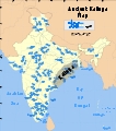
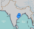
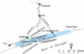
Kalinga (Odia:କଳିଙ୍ଗ, Devnagari:कलिंग) was an early kingdom in central-eastern India, which comprised most of the modern state of Orissa as well as some northern areas of the bordering state of Andhra Pradesh. The region was scene of the bloody Kalinga War fought by the Maurya Emperor Ashoka around 265 BCE.
Media in category "Kalinga, India"
The following 23 files are in this category, out of 23 total.
-
 Ancient Kalinga location or.svg 1,639 × 1,852; 412 KB
-
 Ancient Kalinga location.svg 1,639 × 1,852; 410 KB
-
 Ancient Kalinga map.png 1,280 × 1,446; 528 KB
-
 Constitution Page106 Rammanohar.jpg 7,016 × 4,961; 1.28 MB
-
 Dhauli-Giri-Shanti-Stupa-Bhubaneswar-Orissa.jpg 1,592 × 1,063; 231 KB
-
 Eastern Ganga Fanam.jpg 517 × 263; 52 KB
-
 Estat Kalinga (vèrs 265 avC).png 403 × 342; 21 KB
-
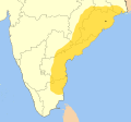 Gajapati Empire map.svg 953 × 883; 321 KB
-
 Kalinga map.png 400 × 337; 9 KB
-
 Kalinga sea routes.svg 749 × 453; 852 KB
-
 Kalinga-es.svg 722 × 759; 364 KB
-
 Kalinga.GIF 400 × 337; 10 KB
-
 Khalkatapatna map.png 429 × 278; 90 KB
-
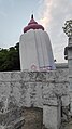 Leaning Temple Huma.jpg 2,268 × 4,032; 4.11 MB
-
 Lord Brahma, 15th century Brahma Temple, Bhubaneswar.jpg 2,709 × 3,672; 5.3 MB
-
 Mapa Kalingy.PNG 1,565 × 1,666; 960 KB
-
 Periodo medievale kalinga, danzatrice, da calcutta, 600-1400 ca.jpg 1,312 × 4,712; 2.97 MB
-

-

-

-
 Periodo medievale kalinga, salabhanjika, da calcutta, 600-1400 ca.jpg 1,424 × 4,520; 3.12 MB
-
 Sunrise kalinga.jpg 2,304 × 1,536; 353 KB
-
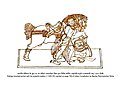
 Utkala Khandayat.jpg 1,491 × 1,121; 1,001 KB


.png)


