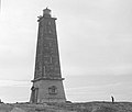
Category:Lågskär Lighthouse
Jump to navigation
Jump to search
| Object location | | View all coordinates using: OpenStreetMap |
|---|
English: Lågskär Lighthouse in Lemland, Åland, Finland.
Suomi: Lågskärin majakka Lemlandissa Ahvenanmaalla.
lighthouse in Finland  | |||||
| Upload media | |||||
| Instance of | |||||
|---|---|---|---|---|---|
| Made from material | |||||
| Location | Lemland, Åland, State Department of Åland, Finland | ||||
| Located in or next to body of water | |||||
| Inception |
| ||||
| Significant event |
| ||||
| Source of energy |
| ||||
| Height |
| ||||
 | |||||
Media in category "Lågskär Lighthouse"
The following 18 files are in this category, out of 18 total.
-
 Lagskar.jpg 1,500 × 1,000; 159 KB
-
 Lågskär; loisto (26737479426).jpg 4,992 × 3,216; 1.02 MB
-
 Lågskär; loisto - 26746882075.jpg 4,984 × 3,260; 1.36 MB
-
 Lågskär; loisto ruohikkoisella kalliolla lähikuvassa (26489943880).jpg 3,213 × 4,519; 3.1 MB
-
 Lågskär; loisto.jpg 5,000 × 3,292; 1.23 MB
-
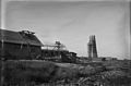 Lågskär; majakan ja talojen rakennustyö.jpg 4,980 × 3,296; 1.58 MB
-
 Lågskär; majakka rakenteilla.jpg 3,284 × 4,944; 1.72 MB
-
 Lågskär; majakkahenkilökunnan asuinrakennus rakenteilla (26142692723).jpg 4,944 × 3,128; 1.91 MB
-
 Lågskär; majakkahenkilökunnan asuinrakennus rakenteilla (26746881345).jpg 4,276 × 3,116; 2.3 MB
-
 Lågskär; majakkahenkilökunnan asuinrakennus rakenteilla.jpg 5,008 × 3,252; 2.23 MB
-
 Lågskär; majakkasaari (26653246062).jpg 4,544 × 3,280; 2.68 MB
-
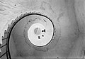 Lågskär; majakkatornin kierreportaat alhaalta nähtynä (26142691433).jpg 4,417 × 3,073; 3.46 MB
-

-

-
 Lågskär; raunioita (26721137066).jpg 5,000 × 3,296; 1.32 MB
-
 Lågskär; tilapäinen loisto heinikkoisella kalliolla (26653243962).jpg 3,523 × 2,743; 2.03 MB
-

-
 The Lågskär Lighthouse. Picture taken between 1939-1945.jpg 3,658 × 3,110; 1.1 MB
.jpg)

.jpg)


.jpg)
.jpg)

.jpg)
.jpg)
.jpg)
.jpg)
.jpg)
.jpg)
.jpg)
