Category:Maps of Bamberg County, South Carolina
Jump to navigation
Jump to search
Counties of South Carolina: Abbeville · Aiken · Allendale · Anderson · Bamberg · Barnwell · Beaufort · Berkeley · Calhoun · Charleston · Cherokee · Chester · Chesterfield · Clarendon · Colleton · Darlington · Dillon · Dorchester · Edgefield · Fairfield · Florence · Georgetown · Greenville · Greenwood · Hampton · Horry · Jasper · Kershaw · Lancaster · Laurens · Lee · Lexington · Marion · Marlboro · McCormick · Newberry · Oconee · Orangeburg · Pickens · Richland · Saluda · Spartanburg · Sumter · Union · Williamsburg · York
| NO WIKIDATA ID FOUND! Search for Maps of Bamberg County, South Carolina on Wikidata | |
| Upload media |
Media in category "Maps of Bamberg County, South Carolina"
The following 6 files are in this category, out of 6 total.
-
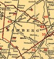 Bamberg County on South Carolina railroads 1900 (cropped).tif 750 × 820; 1.76 MB
-
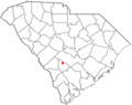
 Map of South Carolina highlighting Bamberg County.svg 1,473 × 1,174; 71 KB
-
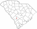
 SCMap-doton-Bamberg.PNG 300 × 237; 12 KB
-
 SCMap-doton-Denmark.PNG 300 × 237; 12 KB
-
 SCMap-doton-Govan.PNG 300 × 237; 12 KB
-
 SCMap-doton-Olar.PNG 300 × 237; 12 KB


