Category:Maps of Mount St. Helens
Jump to navigation
Jump to search
Wikimedia category | |||||
| Upload media | |||||
| Instance of | |||||
|---|---|---|---|---|---|
| Category combines topics | |||||
| Mount St. Helens | |||||
volcano in Washington state  El monte Santa Helena el 19 de mayo de 1982, dos años después de su principal erución.  | |||||
| Instance of | |||||
| Named after | |||||
| Made from material | |||||
| Located in protected area | |||||
| Location | Washington, Pacific Northwest, Washington, Pacific States Region | ||||
| Heritage designation |
| ||||
| Significant event |
| ||||
| Mountain range | |||||
| Topographic prominence |
| ||||
| Elevation above sea level |
| ||||
| Different from | |||||
 | |||||
Subcategories
This category has only the following subcategory.
Media in category "Maps of Mount St. Helens"
The following 15 files are in this category, out of 15 total.
-
 Mshrec.png 1,275 × 1,650; 460 KB
-
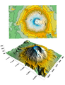 Contour vs Surface Map.png 810 × 1,060; 357 KB
-
 Mount St Helens ESA362439.jpg 1,989 × 2,000; 2.52 MB
-
 Mount St. Helens crater map - Flickr - brewbooks.jpg 3,264 × 2,448; 4.62 MB
-
 Mount St. Helens map - Flickr - brewbooks.jpg 2,845 × 2,375; 2.76 MB
-
 Mount St. Helens Relief Map, SRTM-1.jpg 1,600 × 1,200; 1.49 MB
-
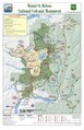 Mount St. HelensNational Volcanic Monument map (2012).pdf 1,650 × 2,550; 1.16 MB
-
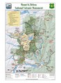 Mount St. HelensNational Volcanic Monument map (2019).pdf 1,650 × 2,250; 2.91 MB
-
 MSH80 Hazard map April 1st.gif 894 × 906; 46 KB
-
 Mshcart.jpg 559 × 600; 369 KB
-
 Rainier Adams Hood Saint Helens Comparison-fr.svg 2,356 × 588; 13.21 MB
-
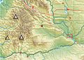
 South Washington Cascade Range topographic map-fr.svg 720 × 722; 6.86 MB
-
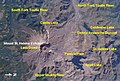 St Helens and nearby area from space.jpg 692 × 465; 270 KB
-
 St helens satellite map.jpg 588 × 854; 353 KB
-
 Yakima Fold Belt map.jpg 641 × 456; 150 KB


