Category:Mount St. Helens
Jump to navigation
Jump to search
|
This is a category about a place or building that is listed on the National Register of Historic Places in the United States of America. Its reference number is 13000748. |
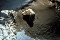
volcano in Washington state  El monte Santa Helena el 19 de mayo de 1982, dos años después de su principal erución. | |||||
| Upload media | |||||
| Instance of | |||||
|---|---|---|---|---|---|
| Named after | |||||
| Made from material | |||||
| Located in protected area | |||||
| Location | Washington, Pacific Northwest, Washington, Pacific States Region | ||||
| Heritage designation |
| ||||
| Significant event |
| ||||
| Mountain range | |||||
| Topographic prominence |
| ||||
| Elevation above sea level |
| ||||
| Different from | |||||
 | |||||
Subcategories
This category has the following 20 subcategories, out of 20 total.
*
+
- Books about Mount St. Helens (2 F)
- Mount St. Helens in art (7 F)
- Videos of Mount St. Helens (5 F)
E
- Erosion at Mount St. Helens (15 F)
F
G
M
- Mount St. Helens cryptodome (6 F)
S
V
W
Pages in category "Mount St. Helens"
This category contains only the following page.
Media in category "Mount St. Helens"
The following 200 files are in this category, out of 364 total.
(previous page) (next page)-
 001MSH and Rainier preerupt resize (21851942158).jpg 1,192 × 800; 138 KB
-
 002MSH climbers resize (22027452522).jpg 1,192 × 800; 162 KB
-
 004MSH Leaves frame mountain resize (21852900519).jpg 1,176 × 800; 334 KB
-
 008 MSH80 phreatic eruption from northwest bw resize (21418655753).jpg 1,200 × 790; 175 KB
-
 008A MSH first crater resize (21851941638).jpg 1,200 × 805; 321 KB
-
 009first eruption resize (21851632550).jpg 1,184 × 800; 203 KB
-
 010first eruption resize (22013613196).jpg 1,191 × 800; 137 KB
-
 011first eruption resize (21851941458).jpg 1,193 × 800; 232 KB
-
 012first eruption resize (21851941328).jpg 1,196 × 800; 255 KB
-
 013MSH80 steam blast from summit resize (21851941338).jpg 1,199 × 800; 170 KB
-
 014MSH80 early eruption st helens from NE resize (21851941258).jpg 1,181 × 800; 286 KB
-
 015MSH80 phreatic eruption st helens spring resize (22013613086).jpg 1,200 × 762; 232 KB
-
 015nutty volcano ash sign resize (21852899739).jpg 1,196 × 800; 236 KB
-
 015roadblockjpg resize (21851941118).jpg 1,196 × 800; 267 KB
-
 016Harry leaves Lodge resize (22027451832).jpg 1,176 × 800; 261 KB
-
 017 warning siesmograph resize (22027451672).jpg 1,176 × 800; 192 KB
-
 0215 sanhill st helens munsel ODFW (4421086040).jpg 2,100 × 1,500; 583 KB
-
 025the eruption column resize (22013612206).jpg 1,200 × 785; 175 KB
-
 026MSH80 eruption mount st helens plume 05-18-80 resize (22027450832).jpg 1,184 × 800; 221 KB
-
 026the eruption mount st helens resize (21416989374).jpg 1,200 × 785; 226 KB
-
 027the helicopters liftoff resize (21416995354).jpg 1,176 × 800; 133 KB
-
 028MSH80 volcanic ash with helicopter 08-22-80 resize (21851636930).jpg 1,200 × 797; 223 KB
-
 039MSH80 blast area spirit lake with rainier 10-04-80 resize (22049729021).jpg 1,177 × 800; 267 KB
-
 040jackstrawed timber resize (22039809615).jpg 1,177 × 800; 473 KB
-
 043MSH80 may18 lahar toutle river I-5 bridge 07-06-80 resize (21418659493).jpg 1,099 × 800; 299 KB
-
 044MSH80 mudflow toutle river bridge 07-01-80 resize (22013617126).jpg 1,200 × 799; 319 KB
-
-
 047MSH80 st helens debris avalanche helicopter 09-16-80 resize (21852904119).jpg 1,183 × 800; 266 KB
-
 048A MSH81 debris aval colorful ponds 08-04-81 resize (22039809405).jpg 1,179 × 800; 410 KB
-
 049mud flow pattern resize (21852904029).jpg 1,187 × 800; 421 KB
-
 050543A Eagle Cr CG Breakfast, Oregon NF (22026718612).jpg 2,800 × 2,152; 3.66 MB
-
 050MSH82 lahar from march 82 eruption 03-21-82 resize (21418659373).jpg 1,200 × 785; 281 KB
-
 052MSH80 st helens from johnston ridge 05-17-80 resize (21416994784).jpg 1,175 × 800; 279 KB
-
 053MSH80 st helens from johnston ridge 09-10-80 resize (22039809225).jpg 1,178 × 800; 224 KB
-
 055MSH82 st helens spirit lake reflection 05-19-82 resize (22039809155).jpg 1,200 × 800; 153 KB
-
 056July 22nd blast resize (22049728551).jpg 1,200 × 800; 213 KB
-
 057MSH82 st helens plume from harrys ridge 05-19-82 resize (22039809135).jpg 1,190 × 800; 251 KB
-
 058 plume resize (22049728531).jpg 1,200 × 769; 274 KB
-
 059 Evacuation of Mt St Helens Ranger District prior to May 18th 1980 (36209262175).jpg 5,324 × 3,604; 13.62 MB
-
 059 MSH84 st helens from johnston ridge 09-24-84 resize (21416994594).jpg 1,200 × 788; 233 KB
-
 060 Ash from Mt St Helens eruption blankets Yakima, WA 5-18-1980 (36209261665).jpg 5,348 × 3,588; 14.54 MB
-
 060 MSH89 crater dome from harrys ridge 05-15-89 bw resize (21852903759).jpg 1,200 × 837; 341 KB
-
 061 Fireweed and MSH resize (21851945358).jpg 1,200 × 808; 951 KB
-
 062 Quiring hikes trail resize resize (22049728331).jpg 1,200 × 819; 493 KB
-
 063 fireweed on slope resize (21851945298).jpg 1,200 × 808; 943 KB
-
 064 Harry Truman talks about his beloved mountain (36209260195).jpg 5,328 × 3,628; 18.61 MB
-
-
 064A MSH institute slide show009 (22027455582).jpg 1,066 × 800; 466 KB
-
 065 Coldwater Peak (22027455542).jpg 1,024 × 680; 289 KB
-
 065 SAR teams recover victims after May 18th eruption (35816054970).jpg 5,324 × 3,616; 17.83 MB
-
 066 Coldwater Ridge (22027455512).jpg 1,024 × 680; 344 KB
-
 066A MSH institute slide show020 (21852903529).jpg 1,200 × 797; 423 KB
-
 066B MSH institute slide show146 (21852903429).jpg 1,024 × 680; 318 KB
-
 067 IMG 2571 resize (21852903419).jpg 1,200 × 800; 475 KB
-
 067A IMG 2570 resize (21852903379).jpg 1,200 × 800; 416 KB
-
 067B stripped trees (21851944958).jpg 1,024 × 680; 400 KB
-
 067D IMG 2553 resize (22027455292).jpg 1,200 × 800; 429 KB
-
 068 IMG 2554 resize (21852903269).jpg 1,200 × 800; 497 KB
-
 069 IMG 2564 resize (22013616166).jpg 1,200 × 800; 473 KB
-
 070 snags and grass resize (22039808465).jpg 1,200 × 808; 485 KB
-
 071 MSH institute slide show014 (21416994134).jpg 1,160 × 800; 421 KB
-
 073 IMG 2568 resize (21416994004).jpg 1,200 × 800; 518 KB
-
 073A MSH institute slide show147 (22027455032).jpg 1,200 × 797; 567 KB
-
 074 Image133 resize (21852903039).jpg 1,024 × 680; 342 KB
-
 075A DSC 0145 resize (22039808275).jpg 1,200 × 797; 288 KB
-
 076 Image113 resize (22013615766).jpg 1,024 × 680; 255 KB
-
 077 MSH institute slide show021 (22027454792).jpg 1,200 × 796; 309 KB
-
 077A IMG 2562 resize (22039808215).jpg 1,200 × 741; 490 KB
-
 077B IMG 2560 resize (22027454802).jpg 1,200 × 800; 497 KB
-
 077C IMG 2574 resize (22013615646).jpg 1,200 × 800; 355 KB
-
 077D IMG 2575 resize (22013615666).jpg 1,200 × 800; 440 KB
-
 077E MSH institute slide show148 (21852902749).jpg 1,024 × 680; 333 KB
-
 077F MSH institute slide show017 (21851944388).jpg 1,200 × 797; 573 KB
-
 078 MSH institute slide show011 (21851634950).jpg 1,200 × 797; 406 KB
-
 081 MSH institute slide show (22027454492).jpg 1,200 × 797; 289 KB
-
 082 MSH institute slide show (21851944178).jpg 1,200 × 797; 263 KB
-
 082A MSH04 crater dome ash on west 10-01-04 resize (22039807785).jpg 1,200 × 900; 344 KB
-
 083 MSH institute slide show (21852902459).jpg 790 × 564; 357 KB
-
 084 MSH institute slide show (22049727131).jpg 1,200 × 797; 150 KB
-
 086 MSH institute slide show030 (21418657783).jpg 1,066 × 800; 300 KB
-
 087 MSH institute slide show024 (21851634630).jpg 1,200 × 797; 250 KB
-
 088 MSH institute slide show025 (22039807685).jpg 1,200 × 797; 241 KB
-
 089 MSH05 dome from sugarbowl camera (21852902329).jpg 1,200 × 900; 358 KB
-
 090 MSH institute slide show026 (21418657673).jpg 1,066 × 800; 189 KB
-
 091 MSH institute slide show027 (21852902259).jpg 1,066 × 800; 202 KB
-
 092 MSH institute slide show028 (22049726911).jpg 1,066 × 800; 158 KB
-
 093 MSH05 aerial st helens with plume from SW 03-08-05 resize (21416993134).jpg 1,200 × 797; 260 KB
-
 094 MSH05 plume from CVO office 03-08-05 resize (22049726871).jpg 1,141 × 726; 409 KB
-
 095 MSH04 new dome from east 11-04-04 resize (21416993044).jpg 1,200 × 797; 287 KB
-
 096 MSH05 aerial st helens from SE 02-03-05 resize (21851943838).jpg 1,200 × 797; 273 KB
-
 097 MSH institute slide show029 (21851634450).jpg 1,066 × 800; 245 KB
-
 098 MSH05 crater new dome from NW 02-22-05 resize (21851943828).jpg 1,200 × 797; 343 KB
-
 099 MSH05 new dome from brutus 03-11-05 resize (22013614986).jpg 1,200 × 897; 418 KB
-
 100 Bull Run area after wildfire (36074466221).jpg 5,396 × 3,612; 7.61 MB
-
 100 MSH05 new dome glacier uplift from east 02-22-05 resize (21418657463).jpg 1,200 × 797; 367 KB
-
 101 MSH05 spine from NE 07-26-05 resize (21852902029).jpg 1,200 × 797; 405 KB
-
 102 MSH05 sharp point on spine 07-26-05 resize (22027453942).jpg 1,200 × 797; 378 KB
-
 102B MSH institute slide show148 (22039807235).jpg 1,200 × 797; 196 KB
-
 103 climb to MSH summit (21418657343).jpg 1,632 × 1,232; 440 KB
-
 105 IMG 2549 resize (21418657293).jpg 1,200 × 800; 452 KB
-
 106 IMG 2543 resize (22027453842).jpg 1,200 × 800; 421 KB
-
 107 IMG 2544 resize (22013614756).jpg 1,200 × 800; 516 KB
-
 108 IMG 2551 resize (21852901739).jpg 1,200 × 800; 502 KB
-
 109 IMG 2580 resize (22013614636).jpg 1,200 × 808; 459 KB
-
 110 IMG 259A resize (22039806855).jpg 1,200 × 800; 292 KB
-
 111 IMG 2572 resize (22013614616).jpg 1,200 × 800; 263 KB
-
 112 IMG 2576 resize (22049726341).jpg 1,200 × 800; 448 KB
-
 113 Massive timber blowdown outside heat blast zone, Mt St Helens eruption (36042509362).jpg 5,324 × 3,604; 17.87 MB
-
 114 IMG 2589 resize (22027453502).jpg 1,200 × 800; 355 KB
-
 114A IMG 2582 resize (21852901569).jpg 1,200 × 800; 213 KB
-
 115 climb to MSH summit (22039806735).jpg 1,632 × 1,232; 474 KB
-
 116 climb to MSH summit (21852901499).jpg 1,632 × 1,232; 458 KB
-
 117 Joint USGS and Forest Service press conference May 18, 1980 (36168091886).jpg 5,328 × 3,592; 18.49 MB
-
 117 MSH institute slide show136 (22039806605).jpg 1,200 × 797; 374 KB
-
 118 institute slide show137 (21416992174).jpg 1,200 × 797; 416 KB
-
 119 MSH institute slide show139 (22027453332).jpg 1,200 × 797; 398 KB
-
 120 MSH institute slide show138 (21852901479).jpg 1,200 × 797; 422 KB
-
 121 MSH institute slide show140 resize (21851942968).jpg 1,069 × 800; 449 KB
-
 122 MSH institute slide show141 (22049725981).jpg 1,200 × 797; 437 KB
-
 123 MSH institute slide show142 (22027453192).jpg 1,066 × 800; 402 KB
-
 124 MSH institute slide show143 (21852901249).jpg 1,066 × 800; 328 KB
-
 125 MSH and dome resize (21851633550).jpg 1,200 × 783; 365 KB
-

-
 127 IMG 2608 resize (21851942838).jpg 1,200 × 800; 367 KB
-
 127 Massive deposit of ash near Mt St Helens volcano (35373446554).jpg 5,312 × 3,620; 15.25 MB
-
 128 Heat blast zone Coldwater Lake, Mt St Helens (36042493442).jpg 5,324 × 3,624; 16.27 MB
-
 128 MSH institute slide show015 (21851633350).jpg 1,200 × 796; 349 KB
-
 129 Devastation after May 18th eruption Mt St Helens (35373444594).jpg 5,324 × 3,596; 15.71 MB
-
 129 MSH institute slide show016 (21852901089).jpg 1,200 × 797; 471 KB
-
 130 Blowndown timber and ash covered forest road (36042492432).jpg 5,324 × 3,604; 14.62 MB
-
 130 MSH steaming000 resize (22013613956).jpg 1,200 × 797; 319 KB
-
 131 Image111 resize (22049725831).jpg 1,024 × 680; 392 KB
-
 132 MSH at sunset001 resize (21418656513).jpg 1,200 × 797; 361 KB
-
 133 MSH institute slide show145 (21851633200).jpg 1,200 × 814; 383 KB
-
 134 MSH institute slide show033 (21851633170).jpg 1,024 × 680; 483 KB
-
 135 MSH institute slide show034 (22049725641).jpg 1,024 × 680; 262 KB
-
 136 MSH institute slide show154 (21416991624).jpg 1,175 × 800; 220 KB
-
 136 Pre-eruption Spirit Lake, Mt St Helens (35816031660).jpg 5,324 × 3,556; 16.23 MB
-
 137 MSH institute slide show150 (22039805985).jpg 1,200 × 797; 130 KB
-
 137 Pre-eruption Mt St Helens (35816030710).jpg 5,324 × 3,556; 19.17 MB
-
 138 MSH institute slide show036 (21852900859).jpg 1,200 × 797; 684 KB
-
 139 MSH institute slide show035 (22027452732).jpg 1,200 × 797; 241 KB
-
 140 MSH institute slide show153 (21418656173).jpg 1,200 × 800; 155 KB
-
 1895 Portland, Oregon.jpeg 1,363 × 319; 169 KB
-
 St Helens and nearby area from space.jpg 692 × 465; 270 KB
-
 2018 Ducati Supersport S.jpg 4,032 × 3,024; 2.78 MB
-
 529754 Mt St Helens Mud Flows 6-28-1980, GPNF, WA (21418547033).jpg 2,304 × 2,199; 2.81 MB
-
 7WondersMuseumWA.jpg 1,588 × 2,100; 257 KB
-
 A bathymetric contour map of Castle Lake, Mount St. Helens.jpg 1,373 × 1,026; 498 KB
-
 Adams04 mount adams from st helens 12-28-04.jpg 2,288 × 1,712; 2.3 MB
-

-

-
 Ape Canyon monitoring equipment 2.jpg 5,312 × 2,988; 2.97 MB
-
 Ape Canyon monitoring equipment 3.jpg 5,312 × 2,988; 3.43 MB
-
 Ape Canyon monitoring equipment.jpg 5,312 × 2,988; 3.22 MB
-
 ApeCanyon-highview-daylight.jpg 600 × 800; 467 KB
-
 Ash (182749625).jpeg 2,048 × 1,365; 622 KB
-
 Blast (Unsplash).jpg 6,000 × 4,000; 7.72 MB
-
 Blast zone (Unsplash).jpg 3,992 × 2,661; 5.72 MB
-
 Blow down area. slide (b77085ec259448af93982d4bb556a604).jpg 2,168 × 1,479; 892 KB
-

-
 Cc-standing-dead.jpg 855 × 576; 317 KB
-
 Cc-Willow-Spring-Oasis.jpg 848 × 536; 252 KB
-
 Climbers on Mount St. Helens, ca 1895 (SARVANT 35).jpg 431 × 599; 34 KB
-
 Climbers with alpenstocks on Mount St. Helens, ca 1895 (SARVANT 58).jpg 1,062 × 744; 68 KB
-
 Columbia River Gorge with Mount Adams and Mount Saint Helens visible.png 4,032 × 3,024; 8.89 MB
-
 Council Crest Park Portland2.jpg 935 × 630; 289 KB
-
 Crater at Mount St. Helens National Volcanic Monument in Washington.jpg 600 × 450; 203 KB
-
 Crater Glacier, the youngest mountain glacier on Earth (Copernicus).png 4,408 × 2,540; 17.38 MB
-
 Crater Rim Panorama.jpg 7,425 × 1,077; 1.53 MB
-
 CreerTerrain.jpg 1,920 × 1,170; 294 KB
-
 Dacite-ThinSection-USGS.jpg 600 × 480; 102 KB
-
 Dawn trip on Nat For Rd 99 into Mount St. Helens from the E - (11226409383).jpg 2,121 × 1,414; 809 KB
-

-

-

-

-
-

-

-
 Deer Hunter Near Mount St. Helens, Washington State, USA..jpg 1,487 × 2,000; 3.71 MB
-
 East of Mount Saint Helens, along Highway 7 (1679533788).jpg 1,094 × 754; 98 KB
-
Eruption of Mount St. Helens, 1980.ogv 22 min 11 s, 400 × 300; 96.91 MB
-
-
-
 Global subaerial volcanic carbon dioxide emissions.pdf 1,500 × 1,125; 70 KB
-

-
 Hiking Mount Saint Helens Rim.jpg 1,280 × 960; 654 KB
-
 Hiking Mount St. Helens.jpg 4,000 × 3,000; 3.76 MB
-
 Hot Spring near Crater Glacier - Flickr - brewbooks (1).jpg 3,264 × 2,448; 5.41 MB
-
 Hot Spring near Crater Glacier - Flickr - brewbooks.jpg 3,264 × 2,448; 3.68 MB
-
 I believe this is what's left of Mt. St Helens. (8666133245).jpg 3,561 × 2,383; 3.98 MB
-
 In Mount St Helens crater - Flickr - brewbooks (1).jpg 3,264 × 2,448; 3.08 MB
-
 In Mount St Helens crater - Flickr - brewbooks (2).jpg 3,264 × 2,448; 3.62 MB
-
 In Mount St Helens crater - Flickr - brewbooks (3).jpg 3,264 × 2,448; 3.45 MB
-
 In Mount St Helens crater - Flickr - brewbooks (4).jpg 3,264 × 2,448; 3.8 MB
-
 In Mount St Helens crater - Flickr - brewbooks.jpg 3,264 × 2,448; 3.39 MB
-
 In the mountains again (Unsplash).jpg 4,000 × 6,000; 8.69 MB
-
 Klickitat Valley Viewpoint (22099264544).jpg 5,760 × 3,840; 10.01 MB
-

.jpg)
.jpg)
.jpg)
.jpg)
.jpg)
.jpg)
.jpg)
.jpg)
.jpg)
.jpg)
.jpg)
.jpg)
.jpg)
.jpg)
.jpg)
.jpg)
.jpg)
.jpg)
.jpg)
.jpg)
.jpg)
.jpg)
.jpg)
.jpg)
.jpg)
.jpg)
.jpg)
.jpg)
.jpg)
.jpg)
.jpg)
.jpg)
.jpg)
.jpg)
.jpg)
.jpg)
.jpg)
.jpg)
.jpg)
.jpg)
.jpg)
.jpg)
.jpg)
.jpg)
.jpg)
.jpg)
.jpg)
.jpg)
.jpg)
.jpg)
.jpg)
.jpg)
.jpg)
.jpg)
.jpg)
.jpg)
.jpg)
.jpg)
.jpg)
.jpg)
.jpg)
.jpg)
.jpg)
.jpg)
.jpg)
.jpg)
.jpg)
.jpg)
.jpg)
.jpg)
.jpg)
.jpg)
.jpg)
.jpg)
.jpg)
.jpg)
.jpg)
.jpg)
.jpg)
.jpg)
.jpg)
.jpg)
.jpg)
.jpg)
.jpg)
.jpg)
.jpg)
.jpg)
.jpg)
.jpg)
.jpg)
.jpg)
.jpg)
.jpg)
.jpg)
.jpg)
.jpg)
.jpg)
.jpg)
.jpg)
.jpg)
.jpg)
.jpg)
.jpg)
.jpg)
.jpg)
.jpg)
.jpg)
.jpg)
.jpg)
.jpg)
.jpg)
.jpg)
.jpg)
.jpg)
.jpg)
.jpg)
.jpg)
.jpg)
.jpg)
.jpg)
.jpg)
.jpg)
.jpg)
.jpg)
.jpg)
.jpg)
.jpg)
.jpg)
.jpg)
.jpg)
.jpg)
.jpg)
.jpg)
.jpg)
.jpg)
.jpg)
.jpg)
.jpg)
.jpg)
.jpg)
.jpg)


.jpg)


.jpeg)


.jpeg)
.jpg)
.jpg)
.jpg)


.jpg)
.jpg)


.png)


.jpg)
.jpg)
.jpg)
_(11226288345).jpg)
_(11226411783).jpg)
.jpg)
.jpg)

.jpg)


.jpg)

.jpg)
.jpg)
.jpg)
.jpg)
.jpg)

.jpg)
.jpg)

.jpg)
_(11226411783)_(Wikivoyage_main_page_banner).jpg)
Categories:
- Mount St. Helens National Volcanic Monument
- Mountains of the Cascade Range
- Mountains of Washington (state)
- 2540s mountains of the United States
- Active volcanoes in Washington (state)
- Subduction volcanoes in Washington (state)
- Breached calderas
- National Register of Historic Places in Skamania County, Washington
- Stratovolcanoes in Washington (state)
- Subglacial volcanoes in Washington (state)
- VEI-6 volcanoes in the United States
- Andesite volcanoes in Washington (state)
- Dacite volcanoes in Washington (state)
- Natural features on the National Register of Historic Places
- Volcanoes in Washington (state)
- Basaltic andesite volcanoes in Washington (state)