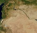
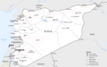
Category:Maps of Syria
Pereiti į navigaciją
Jump to search
Azijos valstybės: Afganistanas · Armėnija‡ · Azerbaidžanas‡ · Bahreinas · Bangladešas · Brunėjaus Darusalamas · Butanas · Egiptas‡ · Filipinai · Gruzija‡ · Indija · Indonezija‡ · Irakas · Iranas · Izraelis · Japonija · Jemenas · Jordanija · Jungtiniai Arabų Emyratai · Kambodža · Kataras · Kazachstanas‡ · Kinijos Liaudies Respublika · Kipras‡ · Kirgizija · Kuveitas · Laosas · Libanas · Malaizija · Maldyvai · Mianmaras · Mongolija · Nepalas · Omanas · Pakistanas · Pietų Korėja · Rusija‡ · Rytų Timoras · Saudo Arabija · Šiaurės Korėja · Singapūras · Sirija · Šri Lanka · Tadžikija · Tailandas · Turkija‡ · Turkmėnija · Uzbekija · Vietnamas
Ribotas pripažinimas: Abchazija‡ · Palestinos valstybė · Pietų Osetija‡ · Taivanas · Turkų Kipras‡ – Kitos teritorijos: Akrotiris ir Dekelija‡ · Honkongas · Indijos Vandenyno Britų Sritis · Makao
‡: partly located in Asia
Ribotas pripažinimas: Abchazija‡ · Palestinos valstybė · Pietų Osetija‡ · Taivanas · Turkų Kipras‡ – Kitos teritorijos: Akrotiris ir Dekelija‡ · Honkongas · Indijos Vandenyno Britų Sritis · Makao
‡: partly located in Asia
- Maps are also available as part of the
 Wikimedia Atlas of the World project in the Atlas of Syria. It is an organized and commented collection of geographical, political and historical maps of Syria.
Wikimedia category | |||||
| Įkelti mediją | |||||
| Tai yra | |||||
|---|---|---|---|---|---|
| Kategorija sujungia temas | |||||
 | |||||
Subkategorijos
Rodomos 35 subkategorijos (iš viso yra 35 subkategorijos).
- Maps of Homs (11 F)
- Maps of Tadmur (2 F)
- Maps of Hama (2 F)
- Maps of Raqqa (8 F)
*
A
B
- Maps of borders of Syria (5 F)
- Blank maps of Syria (8 F)
C
- CIA World Factbook maps of Syria (21 F)
D
E
- ECHO Daily Maps of Syria (18 F)
F
G
H
L
- Linguistic maps of Syria (4 F)
- Location maps of Syria (16 F)
M
- Maps of Quneitra Governorate (26 F)
O
- OpenStreetMap maps of Syria (23 F)
P
S
T
W
Ù
Puslapiai kategorijoje „Maps of Syria“
Rodomi 2 šios kategorijos puslapiai (iš viso kategorijoje yra 2 puslapiai).
Daugialypės terpės rinkmenos kategorijoje „Maps of Syria“
Rodomi 183 šios kategorijos rinkmenos (iš viso kategorijoje yra 183 rinkmenos).
-
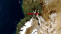
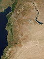
 Region between the seas in the Middle East.png 636 × 470; 347 KiB
-
 0000030 carte de la syrie.jpg 328 × 352; 31 KiB
-

-
-

-
-
 1951 CIA map of Syria – principal Arab and Kurdish tribes, 1951 (margins cropped).jpg 5 260 × 4 244; 3,79 MiB
-

-
 1951 CIA map of Syria – principal Arab and Kurdish tribes, 1951.jpg 5 868 × 4 776; 2,5 MiB
-
 2004 Syria Reference Poster (30849226626).jpg 7 887 × 7 881; 35,16 MiB
-
 2011 CIA Syria country profile map (key).png 1 514 × 1 682; 4,67 MiB
-
 2011 CIA Syria country profile map.png 5 984 × 6 020; 67 MiB
-
 2011 CIA Syria country profile.png 11 774 × 7 839; 179,43 MiB
-
 2011 CIA Syria country profile.tif 11 774 × 7 839; 264,09 MiB
-
 2011 Syria and eastern United States size comparison by the CIA.png 1 210 × 1 224; 2,62 MiB
-

-
 2011 Syria ethnoreligious distribution by the CIA (Golan Heights).png 823 × 828; 1,3 MiB
-
-

-

-
 2011 Syria ethnoreligious distribution by the CIA (map key).png 539 × 750; 728 KiB
-
 2011 Syria ethnoreligious distribution by the CIA (Syrian Kurdistan detail).png 1 911 × 699; 2,45 MiB
-
 2011 Syria ethnoreligious distribution by the CIA (Turkoman areas).png 612 × 382; 453 KiB
-
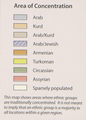
 2011 Syria ethnoreligious distribution by the CIA.png 1 962 × 1 991; 7,35 MiB
-
 2011 Syria Golan Heights by the CIA (map key).png 390 × 181; 126 KiB
-
 2011 Syria Golan Heights by the CIA.png 1 977 × 1 991; 7,58 MiB
-
 2011 Syria location map by the CIA.png 1 220 × 1 224; 2,78 MiB
-
 2011 Syria oil and gas infrastructure by the CIA (inset map).png 740 × 691; 990 KiB
-
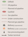 2011 Syria oil and gas infrastructure by the CIA (map key).png 457 × 604; 499 KiB
-
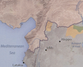
 2011 Syria oil and gas infrastructure by the CIA.png 1 967 × 1 991; 7,33 MiB
-
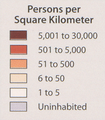 2011 Syria population density by the CIA (map key).png 347 × 397; 253 KiB
-
 2011 Syria population density by the CIA.png 1 967 × 1 980; 7,39 MiB
-
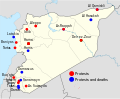
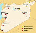
 2011 Syria protests de.svg 922 × 762; 662 KiB
-
 2011 Syria protests-he.svg 922 × 762; 419 KiB
-
 2011 Syria protests-it.svg 922 × 762; 289 KiB
-
 2011 Syria protests-ko.svg 1 219 × 1 009; 121 KiB
-
 2011 Syria protests-ru.svg 865 × 713; 167 KiB
-
 2011 Syria protests.png 922 × 760; 163 KiB
-
 2011 Syria protests.svg 922 × 762; 287 KiB
-
 Abhandlungen der Königlichen Akademie der Wissenschaften in Berlin (1889) (16765601541).jpg 3 528 × 2 750; 1,15 MiB
-
 Airports in Syria.svg 922 × 762; 248 KiB
-
 Al-qaim-area ar.svg 429 × 328; 450 KiB
-
 Al-qaim-area.svg 429 × 328; 415 KiB
-
 ALEPPO GOVERNORATE GEOGRAPHY.jpg 1 224 × 864; 143 KiB
-
 Atlas of ancient and classical geography (1909) (14595742398).jpg 3 500 × 2 302; 1,78 MiB
-
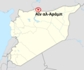 Ayn al-Arab location map.png 725 × 599; 86 KiB
-
 Battle Latakia he.JPG 598 × 525; 33 KiB
-
 Beirut-Damaskus Streckenkarte.JPG 1 166 × 714; 490 KiB
-
 Bishri.png 600 × 500; 48 KiB
-
 C+B-Damascus-Map.PNG 734 × 527; 212 KiB
-
 Caliph Abu Bakr's empire at its peak2-mohammad adil rais.PNG 1 196 × 580; 44 KiB
-
 Cilicië, Cyprus, Syrië en de Fenicische kust in de oudheid.png 865 × 856; 978 KiB
-
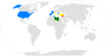 CountriesRecognizingSNC.png 800 × 411; 74 KiB
-
 Damascus Governorate.svg 771 × 696; 22 KiB
-
 Damascus SPOT 1363.jpg 500 × 500; 134 KiB
-
 Dier ezzor map.jpg 400 × 304; 20 KiB
-
 Dust over Syria and Iraq 2010-02-22 lrg.jpg 3 400 × 2 400; 1,37 MiB
-
 Dust over Syria and Iraq 2010-02-22.jpg 720 × 480; 292 KiB
-
 ECDM 20210204 Syria Floods IDPs.pdf 2 479 × 1 754; 962 KiB
-
 ECHO Syria Editable A4 Landscape v2.png 1 123 × 794; 274 KiB
-
 Eisenbahnstrecken Syrien2.png 960 × 720; 33 KiB
-
 FLII Syria.png 1 244 × 897; 127 KiB
-
 Frappes2018syrie.jpg 726 × 633; 34 KiB
-
 Geo siria ghab.png 1 026 × 1 214; 1,91 MiB
-
 Golan Heights relief v2-ar.png 758 × 871; 1 010 KiB
-
 Golan Heights relief v2.png 758 × 871; 923 KiB
-
 Greatersyriapic.png 800 × 566; 342 KiB
-
 Großsyrien SSNP.png 1 000 × 600; 135 KiB
-
 Guvernoráty - sýrie.png 725 × 599; 91 KiB
-
 Hama Governorate.svg 771 × 696; 22 KiB
-
 Haziran 2012 vurulan Türk uçağının rotası.png 464 × 466; 37 KiB
-
 Hims Gap sat.jpg 1 280 × 720; 161 KiB
-
 Homeland of M34.jpg 951 × 712; 78 KiB
-
 Idlib Zone im Syrischen Bürgerkrieg.png 2 000 × 1 654; 1,02 MiB
-
 JordanRiver-ar.png 474 × 599; 60 KiB
-
 Karte Tote Städte in Syrien He.png 1 042 × 1 500; 2,17 MiB
-
 Karte Tote Städte in Syrien.png 1 042 × 1 500; 2,22 MiB
-
 KarteSyrien As-Suwaida.png 330 × 354; 35 KiB
-
 Khabur.png 1 048 × 800; 120 KiB
-
 Khabur2.png 1 048 × 800; 132 KiB
-
 Khareetasureea.JPG 1 000 × 1 028; 385 KiB
-
 KingdomOfEmesa-ar.png 800 × 968; 105 KiB
-
 Koppen-Geiger Map SYR present.svg 1 473 × 850; 709 KiB
-
 LocationUnitedArabRepublic.png 250 × 115; 20 KiB
-
 LocationUnitedArabRepublic2.png 250 × 115; 20 KiB
-
 Manbij (OSM).png 983 × 575; 345 KiB
-
 Manbij, Eufrat (OSM).png 981 × 570; 233 KiB
-
 Mandate of Syria.JPG 681 × 668; 23 KiB
-
 Map of Greater Syria as seen by the Syrian Social-Nationalist Party.svg 512 × 341; 23 KiB
-
 Map of Roman Syria.jpg 523 × 460; 317 KiB
-
 Map of Syria in Hebrew.png 326 × 350; 25 KiB
-
 Map Of Syria With ISO-3166-2 Country Code.png 400 × 357; 15 KiB
-
 Map of Syria with muhafazat.png 672 × 594; 17 KiB
-
 Map Syria and Middle East.png 750 × 750; 117 KiB
-
 Map-Althaala-of-Alswada.jpg 2 639 × 1 866; 489 KiB
-
 Map300616.png 4 501 × 3 439; 1,98 MiB
-
 MiddleEast A2003031 0820 250m without lines.jpg 2 200 × 2 800; 1,7 MiB
-
 MiddleEast.A2003031.0820.250m.jpg 2 200 × 2 800; 1,19 MiB
-
 Near east lrg.jpg 2 987 × 3 967; 2,62 MiB
-
 Northen Syria.svg 2 506 × 770; 1,22 MiB
-
 Northwest Syria Map (Terrain).jpg 740 × 901; 240 KiB
-
 Opposition Forces Territory.jpg 3 300 × 2 550; 1,68 MiB
-
 Osmanlı borçlarını ödeyen ülkeler.png 4 252 × 3 403; 1,02 MiB
-

-

-

-
 PAT - Syria.gif 975 × 860; 300 KiB
-
 PLATEAUS OF SYRIA.jpg 734 × 489; 73 KiB
-
 Pnghgdd.jpg 750 × 601; 93 KiB
-
 Putzger Kleinasien.jpg 5 385 × 3 539; 11,89 MiB
-
 Qusayr map.svg 800 × 500; 488 KiB
-
 Revendications EIIL.png 2 000 × 1 528; 508 KiB
-
 Revendications Etat islamique d'Irak.png 2 000 × 1 528; 509 KiB
-
 SASH D016 Topographical map of syria.jpg 2 394 × 3 896; 3,16 MiB
-
 Satellite image of Syria in May 2003.jpg 2 489 × 2 264; 599 KiB
-
 SatSyria.jpg 660 × 600; 75 KiB
-
 Shebaa Farms-ar.jpg 800 × 1 220; 337 KiB
-
 Shebaa Farms.jpg 800 × 1 220; 169 KiB
-
 Siria Nord ovest Cia.png 871 × 701; 1,11 MiB
-
 Somalia Syria Locator.png 2 312 × 1 284; 263 KiB
-
 Syria (orthographic projection) disputed.svg 553 × 553; 277 KiB
-
 Syria (orthographic projection) uncontrolled highlighted.svg 553 × 553; 467 KiB
-
 Syria (orthographic projection).svg 553 × 553; 290 KiB
-
 Syria (SUGGESTED).svg 983 × 813; 12,12 MiB
-
 Syria 2004 CIA map Jabal al-Druze.jpg 760 × 570; 353 KiB
-
 Syria 2004 CIA map-2010-07-09.JPG 1 004 × 720; 127 KiB
-
 Syria and Lebanon - DPLA - c87ba284854837569695b9c2c6191d6b.jpg 7 990 × 6 312; 3,08 MiB
-
 Syria and Lebanon - DPLA - d015f9a2b9600421c0a5d7b8363e4521.jpg 4 000 × 4 234; 1,55 MiB
-
 Syria and Lebanon - DPLA - f1395a4ba02d025d1d5c076909fe128a.jpg 8 064 × 6 287; 2,91 MiB
-
 Syria and localization.png 250 × 207; 22 KiB
-
 Syria Base Map.png 1 118 × 702; 287 KiB
-
 Syria between 1930 - 1938.png 700 × 580; 198 KiB
-
 Syria cathedral 2019.svg 936 × 778; 1,77 MiB
-
 Syria Crop Land Map.jpg 287 × 213; 17 KiB
-
 Syria disputed w1 countrymap.svg 1 000 × 1 000; 23 KiB
-
 Syria Ethno-religious composition-ar.png 899 × 769; 374 KiB
-
 Syria Ethno-religious composition..jpg 899 × 769; 356 KiB
-
 Syria Ethnoreligious Map.png 1 778 × 1 500; 373 KiB
-
 Syria Gate.png 3 000 × 2 000; 350 KiB
-
 Syria location map road overlay.svg 922 × 762; 66 KiB
-
 Syria location map2.svg 922 × 807; 189 KiB
-
 Syria location map3.svg 922 × 807; 288 KiB
-
 Syria location map4.png 2 500 × 2 066; 475 KiB
-
 Syria map- Hard-to-reach and beseiged areas as of 6 May 2014 (14005556290).jpg 1 647 × 1 281; 495 KiB
-
 Syria Oil Map.gif 649 × 820; 70 KiB
-
 Syria outline map.png 660 × 600; 7 KiB
-
 Syria Political Governorates Map 1976.jpg 994 × 863; 240 KiB
-
 Syria Religion.png 2 029 × 1 873; 232 KiB
-
 Syria war.png 2 468 × 2 072; 1 011 KiB
-
 Syria, Lebanon, Palestine, Transjordan, and Iraq - DPLA - 28336af6e429df936579b3f0a9c01982.jpg 11 794 × 8 165; 11,05 MiB
-
 Syria-blank-governoratesروژاوا.png 630 × 248; 8 KiB
-
 Syria-clip-ua.png 474 × 412; 14 KiB
-
 Syria-Iraq location map.svg 4 485 × 3 428; 959 KiB
-
 Syria-Iraq-Lebanon location map.svg 4 485 × 3 428; 972 KiB
-
 Syria-Religion-Map.jpg 815 × 734; 85 KiB
-
 Syria.A2002158.0810.250m.jpg 1 200 × 1 600; 217 KiB
-
 Syria.A2010269.0800.250m.jpg 4 400 × 3 400; 1,4 MiB
-
 SyriaForAll.jpg 623 × 507; 21 KiB
-
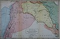
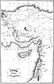 Syrian and a part of Asia Minor.jpg 2 419 × 3 742; 1,29 MiB
-
 Syrian arc 1.jpg 300 × 318; 33 KiB
-
 Syrian Civil War-zh-cn.svg 1 000 × 827; 845 KiB
-
 Syrian Kurdish Area Map.gif 725 × 600; 30 KiB
-
 Syrian Military Units 11-13 February 2012, Az Zabadani, Syria.jpg 800 × 618; 159 KiB
-
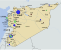
 Syrian revolution 2011 map.jpg 924 × 857; 353 KiB
-
 SYRIE - Vue satellite au 08 février 2012 - Artillerie syrienne - Carte de 9 positions -.jpg 2 250 × 1 688; 1,39 MiB
-
 Syrie revendications.png 328 × 352; 14 KiB
-
 Sýrie guvernoráty.png 725 × 599; 91 KiB
-
 The situation in hasaka.svg 600 × 407; 92 KiB
-
 The Syrian opposition within Syria.png 1 239 × 1 016; 175 KiB
-
 Tirbaspi.jpg 640 × 278; 43 KiB
-
 Topo Map Syria.png 1 354 × 638; 1,4 MiB
-
 Turkish Northern Syria 4.svg 922 × 762; 287 KiB
-
 Turkish Northern Syria3.svg 922 × 762; 287 KiB
-
 Un-syria.png 3 092 × 2 367; 2,21 MiB
-
 Ввс-2015.jpg 873 × 768; 359 KiB
-
 Карта Малой Азии.png 8 500 × 4 137; 3,76 MiB
-
 סוריה-עין דארה.jpg 722 × 597; 26 KiB
-
 الخريطة السورية 2014-02-10 02-29.jpg 261 × 242; 14 KiB
-
 خريطة سوريا.png 280 × 231; 22 KiB
-
 فرق عمل المنتدى السوري.png 1 300 × 792; 204 KiB
-
 موقع سويدان جزيرة.png 458 × 344; 181 KiB
-
 大馬士革城0185 (3).jpg 2 561 × 1 951; 1,42 MiB
-
 敘利亞古蹟176.jpg 3 008 × 2 000; 2,5 MiB


.jpg)
.jpg)
.jpg)
.jpg)
.jpg)

.jpg)
.png)


.png)
.png)
.png)
.png)
.png)
.png)
.png)

.png)


.png)
.png)

.png)


_(16765601541).jpg)


_(14595742398).jpg)


.png)
.png)


.jpg)


_(14586930258).jpg)
_(14770454371).jpg)
_(14597994328).jpg)


_disputed.svg)
_uncontrolled_highlighted.svg)
.svg)
.svg)


.jpg)


.jpg)

.jpg)
.png)