Category:Maps of the history of California
Jump to navigation
Jump to search
States of the United States: Alabama · Alaska · Arizona · Arkansas · California · Colorado · Connecticut · Delaware · Florida · Georgia · Hawaii · Idaho · Illinois · Indiana · Iowa · Kansas · Kentucky · Louisiana · Maine · Maryland · Massachusetts · Michigan · Minnesota · Mississippi · Missouri · Montana · Nebraska · Nevada · New Hampshire · New Jersey · New Mexico · New York · North Carolina · North Dakota · Ohio · Oklahoma · Oregon · Pennsylvania · Rhode Island · South Carolina · South Dakota · Tennessee · Texas · Utah · Vermont · Virginia · Washington · West Virginia · Wisconsin · Wyoming – Washington, D.C.
Puerto Rico
Puerto Rico
English: Maps of the History of California.
Subcategories
This category has the following 6 subcategories, out of 6 total.
B
M
Media in category "Maps of the history of California"
The following 33 files are in this category, out of 33 total.
-
 Nova Espanya a Mèxic.png 600 × 570; 67 KB
-
 Political divisions of Mexico 1824 (location map scheme).svg 649 × 617; 509 KB
-
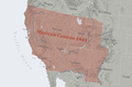 Mexican Cession.png 2,328 × 1,541; 2.81 MB
-
 California Gold Rush relief map.png 724 × 1,071; 991 KB
-
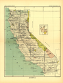 1896 California Map 2 Smithsonian Institute Report.png 1,900 × 2,477; 9.31 MB
-

-
-

-

-
 AmDiscoveryMap.jpg 300 × 211; 32 KB
-
 CalColumnMap.jpg 931 × 503; 142 KB
-
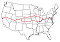
 Wpdms california trail3.png 300 × 200; 24 KB
-
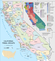 California tribes & languages at contact.png 5,304 × 5,853; 3.53 MB
-
 Cooperative economic insect report (1957) (20698078925).jpg 3,442 × 2,206; 2.07 MB
-
 Cupeño map labeled.svg 512 × 483; 56 KB
-
 Cupeño map svg.svg 512 × 337; 22 KB
-
 History of California (Bancroft), Volume 3 - Coulter's Map.png 1,908 × 3,392; 1.66 MB
-
 History of California (Bancroft), Volume 3 - Map of 1826.png 1,887 × 1,379; 941 KB
-
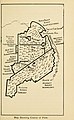
 History of California (Bancroft), Volume 3 - Map of S. Rafael Lands in 1834.png 1,884 × 1,381; 831 KB
-
 Juaneño map.svg 512 × 454; 14 KB
-
 Map of Distribution of Indian Tribes in California by JW Powell 1877.jpg 4,691 × 5,482; 8.01 MB
-
 Map of the San Joaquin, Sacramento and Tulare Valleys 1873.jpg 1,083 × 1,536; 314 KB
-
 Mexico 1824 (equirectangular projection).png 1,400 × 1,047; 405 KB
-
 Mexico 1835-1846 administrative map-de.svg 1,241 × 1,138; 162 KB
-
 Mexico 1835-1846 administrative map-es.svg 1,518 × 1,138; 1.18 MB
-
 Mexico 1835-1846 administrative map-fr.svg 1,241 × 1,138; 416 KB
-
 México División Política-República Central.png 1,098 × 1,181; 319 KB
-
 Salt Lake Route newspaper ad.jpg 717 × 1,035; 171 KB
-
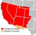 Treaty of Guadalupe Hidalgo.png 320 × 315; 9 KB
-
 Viceroyalty of the New Spain 1800 (without Philippines).png 1,600 × 1,192; 645 KB
-
 Ca-wwiiaflds-cent.jpg 424 × 178; 19 KB
-
 Ca-wwiiaflds-north.jpg 401 × 352; 32 KB
-
 Ca-wwiiaflds-south.jpg 451 × 239; 33 KB

.svg)


_(14804644353).jpg)
_(14579931688).jpg)
_(14764186484).jpg)
_(14786433473).jpg)


_(20698078925).jpg)


,_Volume_3_-_Coulter%27s_Map.png)
,_Volume_3_-_Map_of_1826.png)
,_Volume_3_-_Map_of_S._Rafael_Lands_in_1834.png)


.png)


.png)


