Category:Montgomery County, Arkansas
Jump to navigation
Jump to search
Counties of Arkansas: Arkansas · Ashley · Baxter · Benton · Boone · Bradley · Calhoun · Carroll · Chicot · Clark · Clay · Cleburne · Cleveland · Columbia · Conway · Craighead · Crawford · Crittenden · Cross · Dallas · Desha · Drew · Faulkner · Franklin · Fulton · Garland · Grant · Greene · Hempstead · Hot Spring · Howard · Independence · Izard · Jackson · Jefferson · Johnson · Lafayette · Lawrence · Lee · Lincoln · Little River · Logan · Lonoke · Madison · Marion · Miller · Mississippi · Monroe · Montgomery · Nevada · Newton · Ouachita · Perry · Phillips · Pike · Poinsett · Polk · Pope · Prairie · Pulaski · Randolph · Saline · Scott · Searcy · Sebastian · Sevier · Sharp · St. Francis · Stone · Union · Van Buren · Washington · White · Woodruff · Yell
county in Arkansas, United States   | |||||
| Upload media | |||||
| Instance of | |||||
|---|---|---|---|---|---|
| Named after | |||||
| Location | Arkansas | ||||
| Capital | |||||
| Inception |
| ||||
| Population |
| ||||
| Area |
| ||||
| Different from | |||||
| official website | |||||
 | |||||
Subcategories
This category has the following 17 subcategories, out of 17 total.
A
- Arkansas Highway 88 (8 F)
B
- Blue Phantom Mine (1 F)
C
- Collier Creek Mine (5 F)
M
- Mauldin Mountain Quarries (1 F)
- Minerals of Mauldin Mt (21 F)
- Minerals of Mt Ida (28 F)
- Montgomery County Quarry (2 F)
O
P
- Pigeon Roost Mine (10 F)
R
- Reeves-Melson House (9 F)
Media in category "Montgomery County, Arkansas"
The following 7 files are in this category, out of 7 total.
-
 Eagle Rock vista Arkansas.jpg 6,618 × 2,720; 16.34 MB
-
 Highway 298 in Montgomery County, Arkansas.jpg 4,862 × 2,735; 2.6 MB
-
 Lake Ouachita (193059421).jpeg 2,048 × 1,536; 552 KB
-
 Lake Ouachita north of Mount Ida, Arkansas.jpg 4,032 × 3,024; 2.09 MB
-
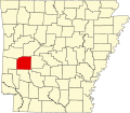 Map of Arkansas highlighting Montgomery County.svg 4,474 × 3,895; 102 KB
-
 Pencil Bluff, AR 001.jpg 5,248 × 2,952; 4.76 MB
-
 USA Montgomery County, Arkansas age pyramid.svg 520 × 600; 7 KB

.jpeg)


